National Weather Summary for Friday, January 30, 2015
by WeatherOps, on Jan 30, 2015 9:47:27 AM
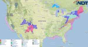
Moderate to heavy snow will be likely Friday across New England. Moderate snow is expected from Central New Mexico into Southern Utah. Moderate to heavy rainfall will be possible across Central and Southern Arizona.
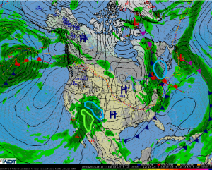
A clipper system moving across New England will spread moderate to heavy snow across much of New England. Most of the snow will fall over the interior region, but 2-5 inches of snow are expected along the I-95 corridor south of Boston. 4-8 inches of snow will be possible for much of New Hampshire and Vermont. 8-14 inches of snow will be possible for the White Mountains and most of Maine. No significant icing is expected.
A mid level trough over the Southwest will allow for moderate to locally heavy snow across much of New Mexico and southern Colorado. 4-10 inches of snow will be possible, with locally higher amounts possible in the higher elevations. In addition, up to .15 inches of ice will be possible for portions of Southern and Central New Mexico.
As a disturbance lingers over the Southwest, moisture from the eastern Pacific will allow for showers across Arizona, southern New Mexico, and the Rio Grande Valley. Rainfall totals are expected to remain under 1.5 inches in most areas, but some areas may receive between 1.5 and 2.5 inches of rain. Some localized flash flooding will be possible.


