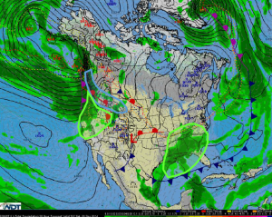
Hazardous Weather Outlook for Saturday, December 20, 2014
by WeatherOps, on Dec 19, 2014 3:45:00 PM
Moderate to heavy snow is possible Saturday for the Pacific Northwest and Rockies. Heavy rain and flooding is possible along the coastal areas of the Pacific Northwest and across the Southeast.
Pacific Northwest/Northern Rockies: Another upper level disturbance will begin to push onshore into the Pacific Northwest on Saturday. Moderate to heavy snow is expected from the Coastal Range to the Northern Rockies, mainly in elevations 3500 ft and higher. Accumulations of 2-10 inches will be possible with localized heaver amounts over 12 inches in areas of highest elevation. Moderate southerly winds will create low visibilities and hazardous travel conditions.
Pacific Northwest: The same upper level disturbance producing moderate to heavy snow through the mountains will produce heavy rain along the coastal areas and valleys in the Pacific Northwest. Accumulations of up to 4.5 inches will be possible, with localized heavier amounts. Due to the heavy rainfall earlier in the week, flooding, power outages and mudslides could occur.
Gulf Coast/Southeast: Showers and thunderstorms will be possible once again on Saturday as a deepening area of low pressure continues to translate eastward. Moderate to heavy rainfall accumulations will be possible through the Gulf Coastal States, with heaviest accumulations possible through Mississippi and Alabama. Up to 2 inches in accumulation could occur, with localized heavier accumulations possible.


