National Weather Summary for Monday, December 8, 2014
by WeatherOps, on Dec 8, 2014 9:54:53 AM
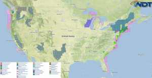
Light to moderate snow will continue Monday across the Great Lakes; some light icing will be possible. Freezing rain, sleet, and snow will be possible from the Appalachians through New England. Moderate to heavy rain is likely along the Mid Atlantic coast, as well as some isolated flooding. To the west, heavy rainfall and localized flooding will be possible along the coast of the Pacific Northwest.
A clipper system moving along the US/Canada border will bring snow to portions of the Great Lakes. 2-4 inches of snow will be possible from Minnesota through Michigan, with locally heavy amounts possible. Some light icing will be possible for portions of Wisconsin in addition to some snow.
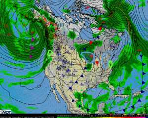
High pressure off the coast of New England and low pressure areas off the Carolinas and over the Great Lakes will allow for a strong winter storm from the Appalachians through New England. Snow, sleet, and freezing rain is expected from the Virginia borders through New England. Up to a tenth of an inch of ice will be possible from the Virginias to Pennsylvania, with locally higher amounts.
With the area of low pressure off the east coast, moderate to heavy rain and localized flooding will be possible for the Carolinas through New Jersey. 2-3 inches of rain will be possible through Tuesday morning.
An area of low pressure will bring a series of disturbances into the Pacific Northwest. 2-4 inches of rain, with isolated regions of heavier rainfall, are expected. Localized flooding and significant flooding are possible.


