National Weather Summary for Monday, September 29, 2014
by WeatherOps, on Sep 29, 2014 9:51:02 AM
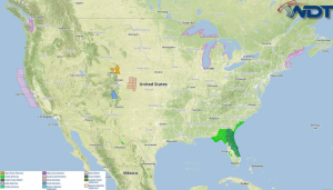
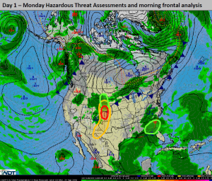
Strong thunderstorms are possible today for portions of the Central High Plains. A few thunderstorms across Eastern Colorado and Western Nebraska may become severe with large hail and tornadoes will be possible. Heavy rain and strong thunderstorms will be possible for portions of the Central and Northern High Plains. Heavy rain will continue for the Northeastern Gulf of Mexico.
Current NWS Advisories/Watches/Warnings in iMapPro:

An upper level disturbance moving across the Central and Southern Rockies will allow for strong to severe thunderstorms across the Central and Southern High Plains. Hail to 1" will be the main threat initially, but into the evening, storms will evolve into a squall line when the main risks will be large hail and winds to 45 mph. Supercells will be possible for portions of Eastern Colorado and Southwestern Nebraska where hail to 1.5" and tornadoes will be possible. Across portions of Western Nebraska and South Dakota, heavy rain will be possible. 1.5"-2.5" of rain will be possible. Isolated to scattered heavy rain and general thunderstorms will be possible across portions of Northern Florida and Southern Georgia. 1-2 inches of rain will be common, but over 2 inches in some areas will be possible.


