National Weather Summary for Tuesday, September 23, 2014
by WeatherOps, on Sep 23, 2014 9:54:22 AM
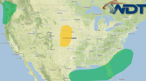
Isolated showers with some strong storms will be possible today across portions of the Central Plains this afternoon and evening. Scattered to widespread rain will be possible from the Central Gulf Coast to the Coastal Carolinas. Very heavy rain is possible for the Carolina coast. For the Coastal Northwest, widespread moderate to heavy rain will be likely.
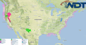
NWS Advisories/Watches/Warnings in iMapPro:

An area of low pressure and the associated upper level disturbance will push across the Central Plains today. Showers moving east across Kansas and Nebraska will continue to weaken through the morning. Thunderstorms will be possible again this afternoon across western portions of Kansas and Nebraska. No widespread severe thunderstorms are expected, but a few wind gusts to 45 miles per hour and hail to .75" will be possible. Widespread moderate to heavy rain will continue across Florida and the central Gulf of Mexico. A low developing along the front will move offshore Florida and the Carolinas, bringing heavy rain from Northeastern Florida through the coastal areas of the Carolinas. In the Pacific Northwest, a new area of low pressure will make landfall. Rain will develop along and west of the Cascades of Washington and Oregon as the system moves ashore. Rainfall will remain under 2 inches, but higher amounts are possible in the coastal mountains and Cascades.


