National Weather Summary for Monday, September 22, 2014
by WeatherOps, on Sep 22, 2014 9:47:00 AM
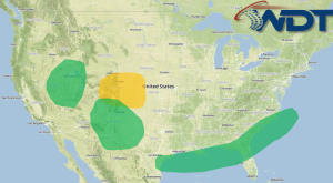
Isolated to scattered showers and thunderstorms will be possible on Monday across the Gulf and Southeast coasts. Showers, thunderstorms, and heavy rainfall will be possible across portions of the Intermountain West and Southern High Plains.
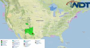
Current NWS Advisories/Watches/Warnings in iMapPro:

High pressure will build across the Eastern US behind a cold front moving southward. Showers and thunderstorms will continue through the morning and afternoon as the front approaches the Southeast and Gulf of Mexico. No severe impacts expected. To the west, an area of low pressure over the Central Rockies will allow isolated to scattered showers and thunderstorms for the Central Rockies. While widespread severe weather is not expected, a few thunderstorms could become severe by late afternoon. Small hail and damaging winds will be the main concerns. Excessive rainfall will be possible across the Great Basin region, Western Colorado, Southern High Plains of New Mexico, and West Texas. 1-1.5" of rain may fall through tonight. Flooding and runoff is expected for parts of Southeast New Mexico.


