National Weather Summary for Friday, September 19, 2014
by WeatherOps, on Sep 19, 2014 9:48:53 AM
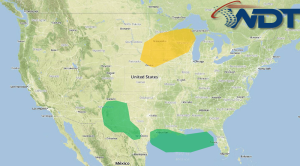
General thunderstorms, with some isolated strong storms, will be possible for portions of the Central Plains and Upper Mississippi Valley on Friday. Flooding will continue from the Southwest into West Texas as moderate to heavy rain continue. Scattered showers and thunderstorms will continue for Southeast Texas; flash flooding will be possible.
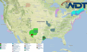
NWS Advisories/Watches/Warnings in iMapPro:

Heavy rain will continue for much of the northern Gulf of Mexico and may continue to impact portions of coastal Texas. Rain totals could range from 1.25 to 2.5 inches. Some thunderstorm activity will be possible, but no widespread severe weather is expected. Tropical moisture associated with Tropical Storm Odile will shift into the Southern Rockies and Plains. Rainfall totals of 1.5"-2.5" will be possible across portions of Eastern New Mexico and Western Texas. A front moving through the Northern Plains may trigger some showers and thunderstorms across the Dakotas in the morning and early afternoon; strong to severe thunderstorms will be possible from Eastern Nebraska to the Upper Peninsula of Michigan. Any thunderstorms will have the potential for wind gusts over 40 mph and hail to 1.25" in diameter. Elsewhere, rain continues off the coast of the Carolinas into the Florida Peninsula. Showers and thunderstorms possible across Arizona and Utah.


