National Weather Summary for Tuesday, September 17, 2014
by WeatherOps, on Sep 16, 2014 9:49:37 AM
General thunderstorms are possible on Tuesday for portions of the Southern Plains through the Ozarks, as well as the Gulf Coast through the Mid Atlantic; locally heavy rainfall will be possible. Scattered showers and thunderstorms will be possible across the Desert Southwest. Locally heavy rainfall and flash flooding will also be possible.
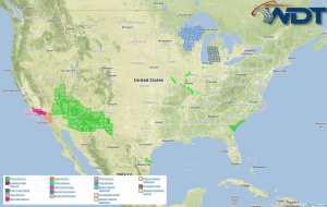
Current NWS Advisories/Watches/Warnings in iMapPro:

A frontal boundary advancing through the Eastern US will produce showers and thunderstorms for portions of the Northeast and the Ohio River Valley, as well as into the Southeast. While widespread severe weather is not anticipated, a few strong to isolated severe thunderstorms will be possible. As the front advances through portions of South Carolina and Georgia, locally heavy rainfall with the potential for flooding will also be possible.
An area of low pressure further west will help to produce showers and thunderstorms through the Central Plains overnight Tuesday into Wednesday. Any storms that develop will have the potential for hail and winds to over 50 miles per hour.
Tropical Storm Odile will continue to lift to the north with additional moisture being transported into the Desert Southwest. Showers and thunderstorms will be possible on Tuesday with accumulations up to 2.5 inches will be possible. Locally heavy rain and flooding will be possible.


