by WeatherOps, on Sep 12, 2014 9:56:39 AM

by WeatherOps, on Sep 12, 2014 9:56:39 AM
Showers and thunderstorms will be possible on Friday for portions of the Southern Plains and Southeast. Scattered showers will be possible for the Central Plains and Upper Midwest.
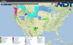
Current NWS Advisories/Watches/Warnings in iMapPro:

An upper level disturbance progressing through the Northern Plains and Upper Midwest will bring scattered showers from Kansas into Iowa with moderate to heavy rain possible. Behind this system, a cold front will move into Central Texas and the Southeast with additional showers and thunderstorms from New Mexico to the Carolinas. Ongoing rainfall through the day for portions of New Mexico and West Central Texas will post a risk for flooding and runoff. Locally heavy rainfall will be possible from the coastal regions of the Carolinas to the Tennessee Valley. An area of low pressure is bringing showers and thunderstorms to portions of the Bahamas and will track across the Southern Peninsula today.
This is where you give the visitor a brief introduction to both this blog and your company. Keep it short. More →