by WeatherOps, on Sep 9, 2014 9:44:18 AM

by WeatherOps, on Sep 9, 2014 9:44:18 AM
Severe thunderstorms are possible today across the Central Plains and Upper Midwest. Showers and thunderstorms are possible across the Southeast coast. Scattered showers are possible for the Four Corners region.
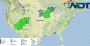
NWS Advisories/Watches/Warnings in iMapPro:

Severe weather chances return today as an area of low pressure deepens over the Rockies and a cold front moves into the Plains. Moderate instability will develop across much of the Upper Midwest and portions of the Central Plains, which will allow for the potential for severe thunderstorms by early afternoon from portions of Nebraska and into Minnesota. Large hail, damaging winds, and tornadoes will be possible. Rainfall over 3 inches will be possible with these storms, creating the potential for significant flooding.
This is where you give the visitor a brief introduction to both this blog and your company. Keep it short. More →