National Weather Summary for Wednesday, August 27, 2014
by WeatherOps, on Aug 27, 2014 9:54:55 AM
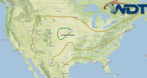
Showers and thunderstorms (isolated severe) will be possible for portions of the Central Plains and Midwest. Scattered thunderstorms will be possible for portions of the Southeast and Gulf Coast. Isolated showers will be possible for portions of the Great Basin and Four Corners region.
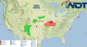
Current NWS Advisories/Watches/Warnings in iMapPro:

Showers and thunderstorms will be possible for the Southern and Central Plains and into the Midwest as an area of low pressure intensifies and moves through the region. A few isolated severe thunderstorms will be possible across portions of Kansas and Nebraska, with hail and damaging winds being the main concerns. An upper level low will allow for showers and thunderstorms across the Great Basin and Four Corners region. A risk for isolated strong to severe thunderstorms will have the potential for hail and damaging winds. Across the Southeast, afternoon showers and thunderstorms will be possible along the coastal areas.
Hurricane Cristobal will continue to advance northward before turning northeast later in the day. Showers and thunderstorms will be possible, as well as seas well over 20 feet in the West Central Atlantic. Cristobal is not expected to be a threat to the East Coast.


