by WeatherOps, on Aug 26, 2014 9:54:47 AM

by WeatherOps, on Aug 26, 2014 9:54:47 AM
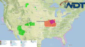
Showers and thunderstorms will be possible for portions of the Central Plains and Midwest; isolated storms may be strong to severe. Isolated thunderstorms will be possible for the Great Basin and Four Corners, as well as the Southeast and the Gulf Coast.
Current NWS Advisories/Watches/Warnings in iMapPro:

Conditions will be calm as high pressure over the Central US moves into the Northern High Plains. A few isolated strong to severe storms will be possible across portions of the Central Plains. Small hail and wind gusts to over 50 miles per hour will be possible. Elsewhere, showers and general thunderstorms will be possible for portions of the Central Plains, Great Lakes, and Southeast.
Hurricane Cristobol will slowly lift to the North to North Northeast today with some strengthening expected. Isolated showers and thunderstorms will be possible from the Northern Bahamas to the east. Cristobol is not expected to be a threat to the US Coastline.
This is where you give the visitor a brief introduction to both this blog and your company. Keep it short. More →