Hazardous Weather Outlook for Wednesday, August 27, 2014
by WeatherOps, on Aug 26, 2014 4:12:36 PM
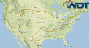
Showers and thunderstorms, with some strong to isolated severe thunderstorms, will be possible Wednesday across the Central Plains and Midwest. Scattered showers and general thunderstorms will be possible for portions of the Southeast and Gulf Coast. Isolated showers and thunderstorms are possible for portions of the Great Basin and Four Corners region.
Showers and thunderstorms will once again be possible across the Southern and Central Plains and into the Midwest as low pressure deepens and slowly advances through the region. A few isolated stronger to severe storms could occur, with damaging winds and hail the primary threats. Otherwise, an upper level low will create conditions favorable for general showers and thunderstorms through the Great Basin and Four Corners region. A marginal risk for stronger to isolated severe storms capable of producing hail and damaging wind gusts could occur as wind shear increases through the area during the afternoon hours. Into the Southeast, afternoon showers and thunderstorms will be possible with highest chances occurring around the coastal areas.
TROPICAL
Hurricane Cristobal will continue to advance northward slowly before turning to the northeast late in the day on Wednesday and into Thursday. Showers and thunderstorms, along with seas well over 20 feet will be possible east of the Carolinas in the West Central Atlantic. Cristobal is expected to remain east of the coast and not a threat to the East Coast at this time. For additional information, please refer to the latest Active Storm Advisory.


