National Weather Summary for Monday, August 25, 2014
by WeatherOps, on Aug 25, 2014 9:48:05 AM
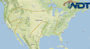
Isolated severe thunderstorms will be possible for portions of the Central Plains and Great Lakes. Scattered showers and thunderstorms with isolated severe thunderstorms will be possible for the Four Corners region. Scattered showers and thunderstorms will be possible across the Gulf Coast.
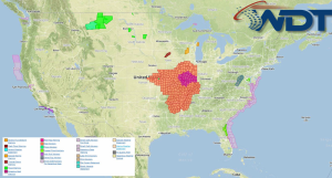
Current NWS Advisories/Watches/Warnings in iMapPro:

A cold front across the Eastern US will extend southwestward from the Upper Great Lakes into the Plains, allowing for the potential for showers and thunderstorms this afternoon. While significant severe weather is not anticipated, a few severe thunderstorms will be possible across portions of Wisconsin and Michigan. By mid morning and early afternoon, the hail and damaging wind threat will have subsided. Elsewhere, isolated to scattered showers and thunderstorms will be possible for portions of the Lower Mississippi River Valley and Southeast. Further west, another area of low pressure will dig into the Great Basin with showers and thunderstorms across the Intermountain West and Southern Rockies. A few thunderstorms could become severe with hail, damaging winds, and isolated tornadoes being possible across eastern portions of Colorado and Wyoming and western portions of Nebraska and Kansas.


