Hazardous Weather Outlook for Friday, August 22, 2014
by WeatherOps, on Aug 21, 2014 4:18:06 PM
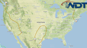
Widespread showers and thunderstorms are possible tomorrow for portions of the Great Lakes and Northeast. Scattered showers and thunderstorms will be possible for the Pacific Northwest and Northern Rockies. Thunderstorms will continue for portions of the Desert Southwest.
Showers and thunderstorms will remain possible across much of the Northeast to the Mid-Atlantic States as low pressure continues to advance offshore on Friday. Severe weather is not currently anticipated, however, moderate to heavy rainfall is possible across the Ohio Valley with accumulations reaching close to 2.5 inches, possibly allowing for localized flash flooding. In addition, a shortwave trough developing through the Northern Plains will bring another round of thunderstorm activity to the region. A few isolated stronger to severe storms could occur with damaging winds and hail the primary threats. Over the Western US, low pressure through the Pacific Northwest will create upslope flow over the Rockies aiding in afternoon activity through much of the region. Further south, additional isolated moderate to heavy precipitation is anticipated as additional monsoonal thunderstorms occur over the Desert Southwest.


