Hazardous Weather Outlook for Thursday, August 21, 2014
by WeatherOps, on Aug 20, 2014 3:42:45 PM
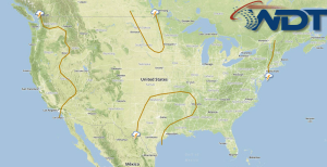
Strong to severe thunderstorms will be possible on Thursday for portions of the Ohio River Valley and the Northeast, as well as for portions of the Northern Plains and Midwest. Hail and damaging winds will be the primary threats. Monsoonal thunderstorms will continue for the Desert Southwest.
Severe weather is not anticipated on Thursday. Low pressure will continue to advance through the Northeast with additional shower and thunderstorm activity expected through much of the region. Limited moisture/instability and weak vertical wind shear will keep a marginal risk for stronger storms to develop during the afternoon hours through the Ohio Valley and into the Northeast. While severe storms are not anticipated, damaging winds and hail could occur with stronger storms. Into the Plains, another round of thunderstorms will develop during the afternoon hours through the Northern Plains and Midwest. While severe weather is not currently anticipated, modest instability and weak vertical wind shear could aid in storms producing locally heavy rainfall, damaging winds and isolated hail. Once again on Thursday, additional showers and thunderstorms are expected through the Desert Southwest with locally heavy rainfall and isolated stronger to severe storms possible.


