Hazardous Weather Outlook for Wednesday, August 20, 2014
by WeatherOps, on Aug 19, 2014 4:17:04 PM
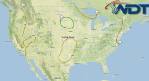
Thunderstorms will be possible on Wednesday for portions of the lower Ohio River Valley. Across the High and Northern Plains, severe thunderstorms with the potential for large hail, damaging winds, and isolated tornadoes will be possible, in addition to heavy rain and flash flooding. Monsoonal thunderstorms will continue across the Desert Southwest.
Activity will continue through the Great Lakes and into the Northeast as low pressure advances eastward through the region. While severe weather is not anticipated, a few isolated stronger to severe storms could occur with the main threats remaining damaging winds and isolated hail. Further west, a deepening low pressure area in the Northern Plains will create conditions favorable for severe storms during the afternoon hours. Ample moisture, moderate instability and vertical wind profiles will promote rotating thunderstorms capable of producing damaging winds, locally heavy rainfall and hail. A few isolated tornadoes cannot be ruled out. In addition, as the low translates eastward, accumulations of up to 2 inches will be possible. Localized flooding could occur. Into the Desert Southwest, additional monsoonal moisture will be transported into the region keeping isolated showers and thunderstorms possible again on Wednesday. Localized heavy rainfall and a few stronger storms could occur with winds over 40 mph.


