by WeatherOps, on Aug 18, 2014 9:36:13 AM

by WeatherOps, on Aug 18, 2014 9:36:13 AM
Severe thunderstorms are possible today for portions of the Upper Mississippi Valley.
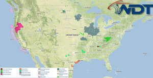
Current NWS Advisories/Watches/Warnings in iMapPro:

The severe weather in the Northern Plains will shift into the Upper Mississippi Valley. The trough that caused the thunderstorms yesterday will strengthen and dig further to the south. Storms developing this afternoon across portions of Iowa and Minnesota will have a potential for large hail and damaging winds. In addition, isolated flooding will be possible for portions of Minnesota. Excessive rainfall will be possible for portions of the North Central Atlantic Coast. Strong storms moving through portions of the northern portions of the Gulf Coast states could see some flooding with over two inches of new rain possible.
This is where you give the visitor a brief introduction to both this blog and your company. Keep it short. More →