by WeatherOps, on Aug 12, 2014 9:48:24 AM

by WeatherOps, on Aug 12, 2014 9:48:24 AM
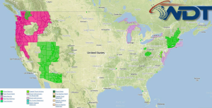
Severe thunderstorms and heavy rain will be possible for portions of the Northeast today. Severe thunderstorms will be likely for portions of the Pacific Northwest. Showers and general thunderstorms will extend from the Gulf Coast into the Carolinas.
Current NWS Advisories/Watches/Warnings in iMapPro:

An upper level low will shift into the Pacific Northwest today as a ridge over the Rockies moves into the Plains. A front will approach the Gulf Coast as showers and thunderstorms move into the Northeast. Two areas of severe weather are expected today. The first will be across the Northeast. A strong surface low will allow for the development of severe thunderstorms with damaging winds being the main concern, but isolated tornadoes and hail will also be possible. Heavy rain up to 3 inches will be possible. Across the Northwest, and upper level low will allow for the potential for severe thunderstorms capable of large hail and damaging winds.
This is where you give the visitor a brief introduction to both this blog and your company. Keep it short. More →