by WeatherOps, on Aug 11, 2014 9:50:30 AM

by WeatherOps, on Aug 11, 2014 9:50:30 AM
Scattered showers and thunderstorms will be possible for the Eastern US. Showers and thunderstorms will be possible for portions of the Southeast and across the Great Basin and Four Corners region.
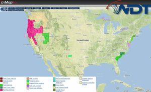
Current NWS Advisories/Watches/Warnings in iMapPro:

No major changes are expected across the US. A ridge of high pressure will remain across the Northern Rockies on Monday while an area of low pressure is expected to dig into the Midwest late in the day. This will allow for a trough over the eastern US, bringing a cold front across the Southern Plains and Ohio River Valley. Excessive rainfall will be possible for portions of the Ohio and Tennessee Valleys. While significant impacts are not expected, a few severe thunderstorms will be possible for portions of the Upper Midwest and into Kentucky. A persistent upper level low over northern California will contribute to more isolated to scattered showers across the Great Basin and Four Corners region.
This is where you give the visitor a brief introduction to both this blog and your company. Keep it short. More →