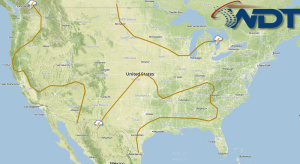
Hazardous Weather Outlook for Tuesday, August 5, 2014
by WeatherOps, on Aug 4, 2014 4:22:52 PM
Scattered showers and isolated thunderstorms will continue from New England to the Gulf Coast. Isolated thunderstorms will be possible for portions of the Midwest and Ohio Valley.
Severe weather is not anticipated on Tuesday. As the overall weather pattern will remain unchanged for an additional day. Showers and thunderstorms will be possible again through the eastern coast to the Gulf as a frontal boundary advances off the east coast. Tropical Storm Bertha will continue to pass offshore of the US on Tuesday and into Wednesday but no impact is expected across the CONUS. Further north, a low pressure disturbance moving through Midwest and Ohio Valley will continue to advance eastward allowing for isolated showers and general thunderstorms, mainly during the afternoon period.
Monsoon moisture will begin to recede across the Southwestern US on Tuesday with not isolated showers and a stray thunderstorm possible. An approaching trough from Southern Canada will allow for the chance of isolated showers and storms across the Northern Rockies but no severe weather is currently expected.


