Hazardous Weather Outlook for Friday, August 1, 2014
by WeatherOps, on Jul 31, 2014 4:01:10 PM
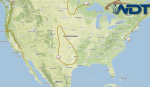
Showers and thunderstorms will continue through the Northeast on Friday. Heavy rain is possible through the Mid Atlantic. Showers and thunderstorms will continue for portions of the Northern Gulf along a stalled front.
A lingering upper level trough across the Great Lakes will allow for isolated showers and general thunderstorms across much of the Eastern half of the country. As the frontal boundary slowly propagates eastward, showers and thunderstorms along the East Coast will continue. Moderate to heavy rain will be possible through the region, with heaviest accumulations through the Mid-Atlantic states and offshore. Up to 2 inches in accumulation will be possible.
Further south, the stalled front across the Northern Gulf of Mexico combined with a dissipating area of low pressure through the Southern Plains will maintain the chance of showers and general thunderstorms from the Southern Plains and into the Lower Mississippi Valley. Severe weather is not expected at this time. Periods of moderate to heavy rain could occur with accumulations of up to 1 inch possible.


