National Weather Summary for Monday, July 28, 2014
by WeatherOps, on Jul 28, 2014 9:55:39 AM
Isolated severe thunderstorms are possible today for portions of the Eastern US and Gulf Coast. Heavy rain and flooding will be possible for portions of the Western US.
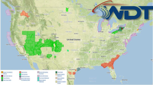
Current NWS Advisories/Watches/Warnings in iMapPro:

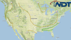
Strong to severe thunderstorms will be possible today from the Northeast to the Gulf Coast ahead of a cold front. The severe threat will be isolated in nature across the Northeast and Mid Atlantic, with a somewhat higher threat anticipated across the Southeast and Gulf Coast. With any storms that develop, damaging winds will be the main concern, but large hail and isolated tornadoes will also be possible.
Storms will also be possible across the Rockies and Great Basin. Thunderstorm activity will not be severe, but gusty winds will be possible. The main concern will be flooding in areas with poor drainage or areas that have received heavy rain recently.
Showers and thunderstorms across the Texas Panhandle and Western Oklahoma will weaken and taper through the day. Locally heavy rain will be the main concern with this activity.


