National Weather Summary for Monday, July 21, 2014
by WeatherOps, on Jul 21, 2014 9:55:24 AM
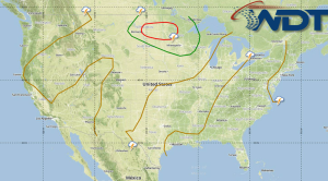
Severe thunderstorms are possible today for portions of the Northern Plains and the Upper Midwest. Showers and thunderstorms, as well as heavy rain will continue across the Southeast.
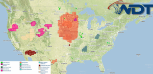
NWS Advisories/Watches/Warnings in iMapPro:

An upper level disturbance and cold front moving across the Northern Plains and Upper Midwest will bring a moderate threat of severe weather. Some non severe thunderstorms across the Dakotas will clear out by the afternoon, but redevelopment is possible along outflow boundaries. Warming temperatures will allow instability to increase. Isolated thunderstorms are expected to develop across the Dakotas late this afternoon and into the evening. Large hail and damaging winds will be the main concerns, but isolated tornadoes can't be ruled out. Storms will organize into a linear structure, posing a damaging wind and heavy rain event.
A stationary front will remain over the Southeast, but will remain a focal point for showers and thunderstorms. Locally heavy rain will be possible.


