by WeatherOps, on Jul 15, 2014 9:54:42 AM

by WeatherOps, on Jul 15, 2014 9:54:42 AM
Severe thunderstorms are possible today for portions of the Central High Plains and Mid Atlantic.
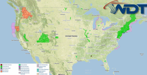
Current NWS Advisories/Watches/Warnings in iMapPro:

A strong jet will move into the Northeastern US, allowing for the potential for severe weather. Lines and clusters capable of hail and damaging winds will be possible; a few isolated tornadoes cannot be ruled out. Upslope flow over the High Plains across Wyoming into Colorado combined with moist air will allow for moderate instability and the development of thunderstorms. Severe thunderstorms capable of large hail, damaging winds, and tornadoes will be possible this afternoon and evening. A cold front across the Upper Northeast and Atlantic Coast through the Gulf Coast will allow for thunderstorms across this region. Around 2 inches of rainfall is possible with isolated higher amounts, causing localized flooding and flash flooding.
This is where you give the visitor a brief introduction to both this blog and your company. Keep it short. More →