National Weather Summary for Monday, July 14, 2014
by WeatherOps, on Jul 14, 2014 9:42:40 AM
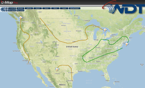
Showers and thunderstorms will be possible today across portions of the Southern Plains, Midwest, and Mid Atlantic; some thunderstorms may become severe. Isolated severe thunderstorms will be possible for portions of the Central and Southern High Plains. Scattered thunderstorms will be possible for portions of Northwestern Texas and Florida.
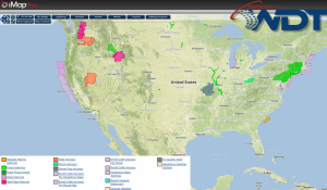
Current NWS Advisories/Watches/Warnings in iMapPro:

A strong area of low pressure is making its way into the US. Much cooler temperatures are moving into the Northern Plains and Upper Midwest behind a cold front. Thunderstorm coverage is expected to increase along the front as it pushes into the Midwest and Southern Plains.
Ongoing showers and thunderstorms across the Ohio Valley along a frontal boundary. By late morning or early afternoon, redevelopment or reintensification of thunderstorm activity is likely with damaging winds possible through the evening from Arkansas into Southern New England.
Further south, a weak area of low pressure will allow for isolated to scatterred thunderstorms across Texas, but no severe impacts expected.
While significant severe weather is not expected, thunderstorms with the potential for hail and damaging winds will be possible across the Colorado Front Range. Some storms may be severe with a risk for large hail and damaging winds. Storms will move southeast and will expand into New Mexico and Texas just before dark.


