National Weather Summary for Thursday, July 3, 2014
by WeatherOps, on Jul 3, 2014 9:53:30 AM
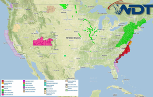
Hurricane Arthur will pass just offshore of North Carolina today with locally heavy rain and fresh to near gale winds likely. Across the Northeast, there will be a slight risk for thunderstorms across the Northeast; hail and damaging winds will be possible. Across the Western High Plains and Northern Plains, stronger to isolated severe thunderstorms with hail and damaging winds will be possible.
Current NWS Advisories/Watches/Warnings in iMapPro:

Widespread severe weather is not expected, however, general to isolated severe thunderstorms will be possible for portions of the Mid Atlantic into the Northeast as a cold front begins to push offshore. Moderate instability and moisture will be sufficient for the development of thunderstorms capable of hail and damaging winds.
Across the west, a shortwave disturbance will bring showers and thunderstorms to portions of the Western High Plains. Daytime heating will be sufficient to allow the development of thunderstorms across the Northern Rockies capable of large hail and damaging winds.
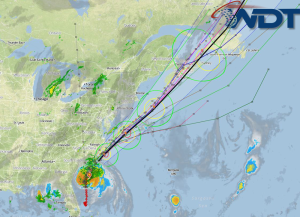
Hurricane Arthur will begin to turn more toward the north or northeast today and is expected to strengthen through the afternoon. Showers and thunderstorms will be possible from Florida to North Carolina. Up to an inch of rain will be possible in some areas with 4-6 inches possible along the outer banks. Strong to isolated severe thunderstorms will be possible with damaging winds, heavy rain, and tornadoes the main threats.
Current iMapPro Radar Mosaic/IR Satellite/Forecast Track/Model Track for Tropical Storm Arthur:


