Hazardous Weather Outlook for Wednesday, July 2, 2014
by WeatherOps, on Jul 1, 2014 4:27:21 PM
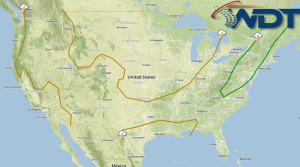
There is a slight risk for severe thunderstorms on Wednesday for portions of the Mid Atlantic and Northeast; hail and damaging winds will be possible. Along the Eastern Florida coast, additional strengthening of Tropical Storm Arthur expected with heavy rain and moderate to fresh winds likely.
As the front continues to progress eastward through the eastern half of the US another round of showers and thunderstorms are expected to develop across the Southern Plains to the Northern New England coast. As temperatures rise through the eastern half of the US and conditions begin to destabilize through the Appalachians and Northern Gulf States, some stronger to isolated severe storms will be possible with hail and damaging winds possible.
Tropical Storm Arthur will continue to strengthen on Wednesday before it begins to be lifted northward along the coast late in the day. This area of convection will continue to drift along the Gulf Stream which is expected to enhance development over the day and into Thursday. Surface winds are expected to average 50 to 60 mph and could near category 1 Hurricane status late in the day into Thursday morning. Heavy rain associated will be likely with the system off the coast of Florida/Georgia with accumulations up to 5 inches will be possible.


