National Weather Summary for Monday, June 30, 2014
by WeatherOps, on Jun 30, 2014 9:55:27 AM
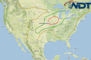
There is a risk for severe thunderstorms with the potential for large hail, damaging winds, and tornadoes for portions of the Central Plains, Midwest, and Great Lakes. Showers and thunderstorms, with locally heavy rain, will be possible for the east coast of Florida to the Northern Bahamas.
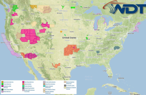
Current NWS Advisories/Watches/Warnings in iMapPro:

A frontal boundary progressing eastward across the Midwest and Great Lakes will allow for the development of showers and thunderstorms this afternoon through the overnight hours. Ample moisture and vertical wind profiles will allow for the development of thunderstorms along the frontal boundary. As thunderstorms develop, they will become severe with large hail, damaging winds, and tornadoes possible. A weak area of low pressure out of the Southern Rockies will generate thunderstorms across the Southern Plains with hail and damaging winds being the main threats.
Additional rainfall will continue across the Midwest today. The heaviest rain will be across portions of Iowa, Illinois, and Wisconsin where up to 4 inches of rain will be possible; some localized flooding could occur.
An unorganized area of thunderstorms will develop across the Southeastern Atlantic Coast. Rain amounts will be under an inch. Stronger storms could produce heavy rain, lightning, and an isolated tornado.


