Hazardous Weather Outlook for Tuesday, July 1, 2014
by WeatherOps, on Jun 30, 2014 4:19:57 PM
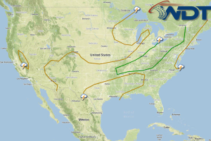
There will be a slight risk for thunderstorms capable of large hail and damaging winds tomorrow across the Midwest and Ohio River Valley. Heavy rain and strong winds will be possible along the Eastern Florida Coast and Northern Bahamas in association with the strengthening of a tropical low.
The same frontal boundary producing showers and thunderstorms through the Central Plains and Midwest on Monday will continue eastward with additional activity anticipated to develop from the Southern Plains into the Great Lakes/Ohio Valley and Northeast. While significant severe weather isn’t currently anticipated, some stronger to isolated severe storms could occur with the main risks remaining damaging wind gusts over 50 mph and hail.
Additional strengthening of low pressure off the coast of Florida will continue through Tuesday. Light to moderate rain and isolated thunderstorms will be possible as the low meanders slowly along the coast with heavy rainfall accumulations of up to 3 inches. Sustained winds will remain between 15-30 mph with additional strengthening anticipated before the low is ejected northward.


