National Weather Summary for Friday, January 31, 2014
by WeatherOps, on Jan 31, 2014 9:42:51 AM
Moderate to heavy snow will continue across the Central Rockies today ahead of an area of low pressure. Light to moderate snow will continue through tonight for portions of the Central Plains and Lower Midwest.
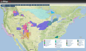
Current NWS Advisories/Watches/Warnings from iMapPro

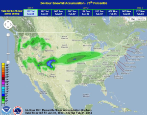
The area of low pressure approaching the Four Corners region is streaming moisture from the Pacific into the Central Plains. High pressure building into the Northern and Central Plains will bring in colder temperatures, as well as light to moderate snow. The heaviest of the snow will fall over portions of the Central Rockies where 4-10 inches of snow will be possible through Saturday Morning. For portions of the Plains, 3-6 inches of snow will be possible for portions of Kansas, Missouri, Iowa, and Illinois. Accumulations of more than 6 inches will also be possible for portions of Southwestern Kansas through Saturday Morning.
WDT Preferred Forecast for snow accumulation

Though Chicago only got four tenths of an inch of snow yesterday, January 2014 has gone down as Chicago's third snowiest month since records started being kept in 1884. Ahead of this record are 40.4 inches in January 1979 and 42.5 inches in January 1918. Heavy snow has fallen across portions of Colorado, leading to power outages in parts of Denver. Up to 3 feet of snow has fallen in some of the mountain resorts.


