National Weather Summary for Friday, January 17, 2014
by WeatherOps, on Jan 17, 2014 9:49:18 AM
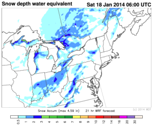
The blizzard conditions that affected portions of the Dakotas and Minnesota yesterday have subsided, but some light snow is still possible for portions of Iowa, Minnesota, South Dakota, and Wisconsin ahead of an area of low pressure moving south out of Canada. Up to 7 inches of snow will be possible through tomorrow afternoon. Some light snow is also possible for portions of Kentucky, Ohio, and West Virginia through tonight. No major problems are expected, but 1-3 inches of snow will be possible.

WDT WRF snow accumulation through 1AM CDT Saturday
In the wake of the blizzard yesterday in portions of the Dakotas, crews are taking to the roads to clear them. Winds were 30-40 miles per hour with gusts as high as 60 miles per hour. Conditions were bad enough that city officials in Sioux Falls, North Dakota considered conditions too dangerous for road crews to be out.
Fires are also continuing for portions of Southern California where more than 1,700 acres have been burned. The Santa Ana winds have been blamed for exacerbating conditions, spreading fires to the mountain areas and into communities.
DM


