National Weather Summary for Wednesday, October 31, 2018
by David Moran, on Oct 31, 2018 10:53:29 AM
Thunderstorms are expected to develop from Texas into the Lower Mississippi Valley on Wednesday ahead of a cold front. These storms will have the potential to produce excessive rainfall from East Texas into the Ohio Valley. Snow will continue across Colorado and New Mexico through Thursday. Elevated winds and seas are expected for the western Gulf of Mexico through early Friday.
- Thunderstorms from Texas into the Lower Mississippi Valley on Wednesday
- Excessive Rainfall Wednesday from East Texas into the Ohio Valley
- Snow for Colorado and New Mexico through Thursday
- Elevated Winds and Seas through Friday Morning for the Western Gulf of Mexico
- Potential for Thunderstorms Thursday across the Southeast
- Risk for Excessive Rainfall from the Central Gulf Coast to the Lower Great Lakes on Thursday
- Thunderstorms for the East Coast on Friday
- Excessive Rainfall Friday across the Northeast
- Tropical Update
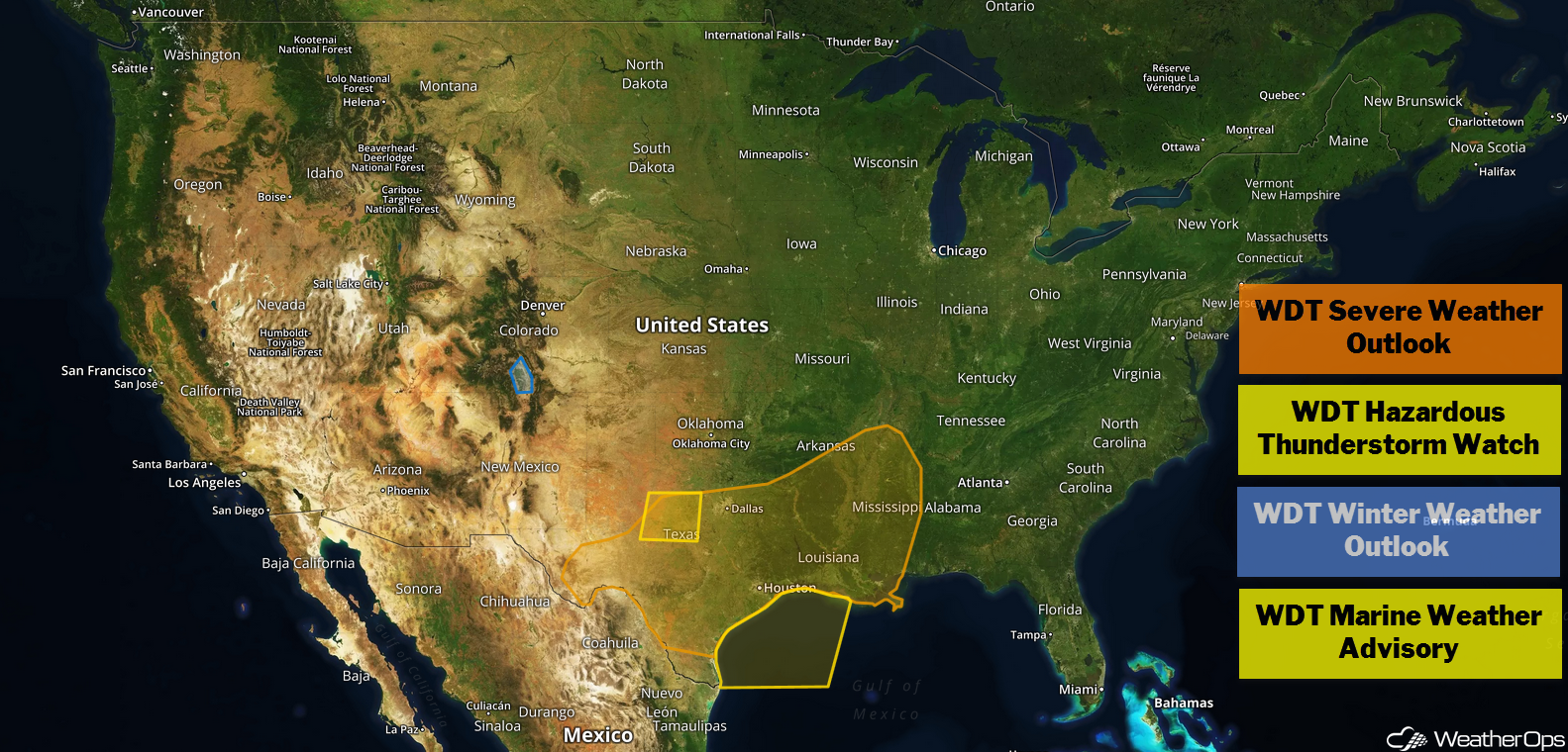
US Hazards
Thunderstorms from Texas into the Lower Mississippi Valley on Wednesday
Scattered thunderstorms are ongoing across west-central Texas and expected to move eastward throughout the day. Daytime heating and plentiful moisture across the region will allow these thunderstorms to strengthen and increase in coverage throughout the day. By late afternoon and early evening, storms will likely be strong to severe with large hail, damaging winds, and tornadoes as potential hazards. These storms will continue into the overnight hours as they push eastward.
Major Cities in Region: Austin, TX, Houston, TX, Shreveport, LA, Baton Rouge, LA, Jackson, MS
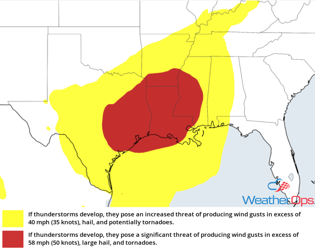
Thunderstorm Risk for Wednesday
Excessive Rainfall Wednesday from East Texas into the Ohio Valley
A cold front moving across the region will likely produce widespread showers and thunderstorms. With plentiful moisture spreading northward from the Gulf of Mexico, there will be a potential for excessive rainfall. The front will slowly move eastward throughout the day. Widespread rainfall totals of 2-4 inches with locally higher amounts in excess of 5 inches are forecast, leading to the potential for flash flooding.
Major Cities in Region: Houston, TX, Little Rock, AR, Paducah, KY
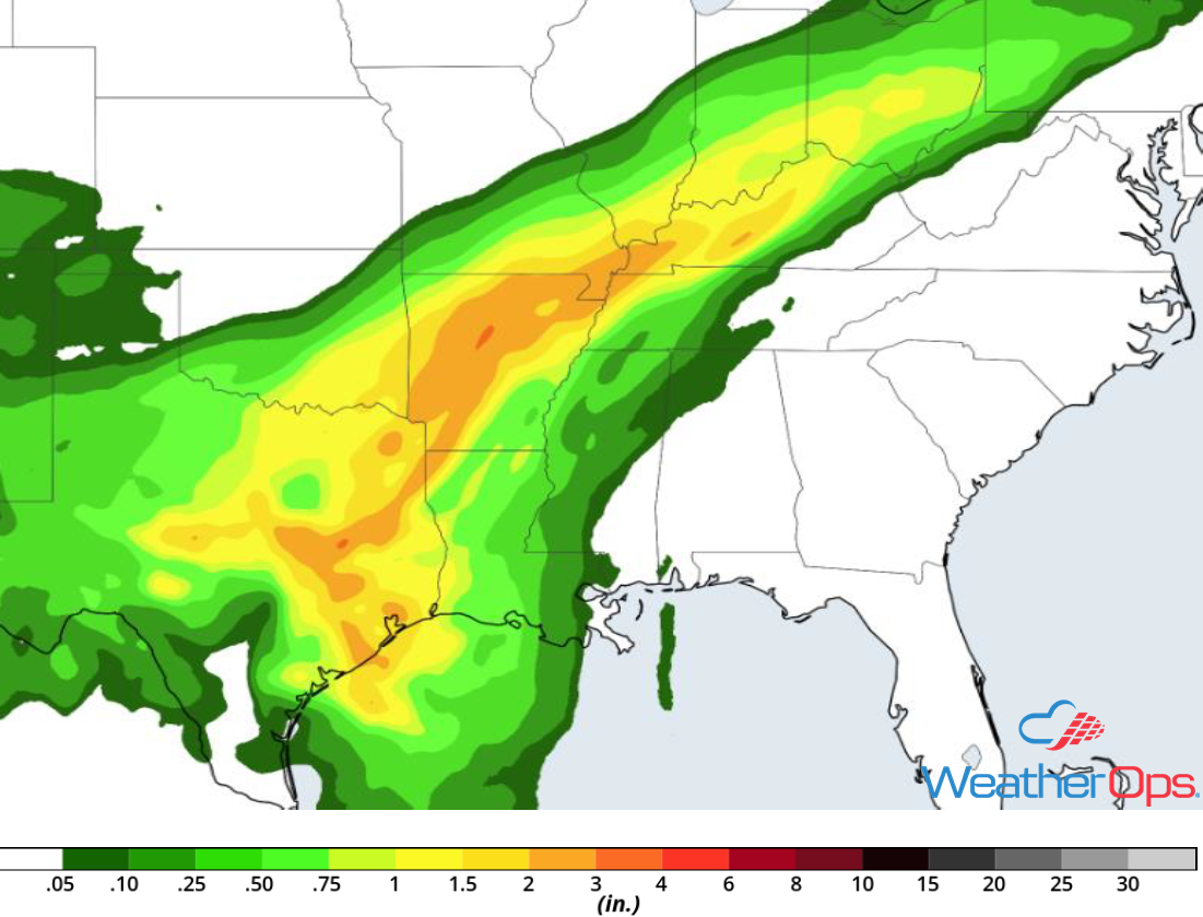
Rainfall Accumulation for Wednesday
Snow for Colorado and New Mexico through Thursday
Snow will continue across parts of the Rockies Wednesday and Thursday as an upper level trough moves across the region. Snowfall totals of 2-4 inches are likely in the lower elevations with 8-12 inches expected above 7500 feet. In addition, light icing may allow for hazardous travel conditions.
Major Cities in Region: Colorado Springs, CO, Pueblo, CO, Trinidad, CO
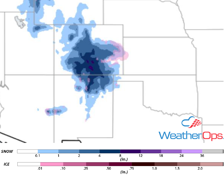
Snow Accumulation through Thursday
Elevated Winds and Seas through Friday Morning for the Western Gulf of Mexico
A strong cold front is forecast to move off of the Texas coast and across the Gulf of Mexico early Thursday morning, allowing for enhanced winds and seas. Winds will become northwesterly to northerly at 25-35 knots Thursday morning. These winds will continue through early Friday afternoon. Seas will range 7-10 feet. In addition, strong to severe thunderstorms may develop along the front.
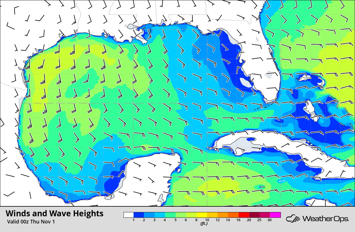
Winds and Wave Heights 7pm CDT Wednesday
Potential for Thunderstorms Thursday across the Southeast
A cold front is expected to move eastward across the Southeast on Thursday. Cloud cover may limit instability, but a line of thunderstorms should be ongoing during the morning. As the day progresses, some strengthening of these storms is anticipated with severe winds and large hail the primary hazards. An isolated tornado or two cannot be ruled out. As these storms move across the Carolinas, they may produce an isolated severe wind gust.
Major Cities in Region: Baton Rouge, LA, Jackson, MS, New Orleans, LA, Mobile, AL, Birmingham, AL, Macon, GA, Columbia, SC, Raleigh, NC, Charleston, SC, Myrtle Beach, SC
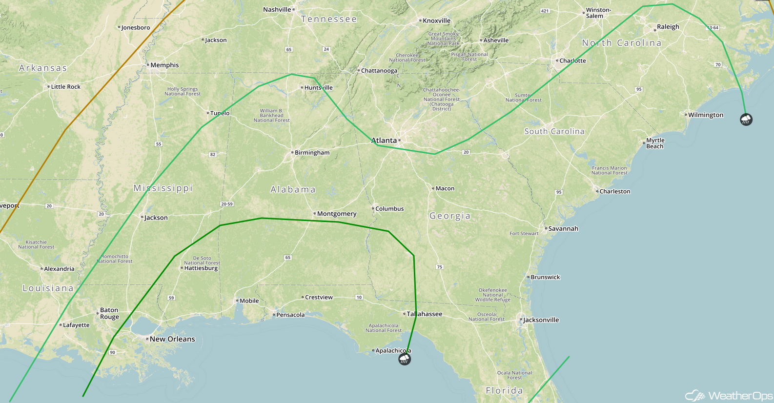
SPC Convective Outlook for Thursday
Risk for Excessive Rainfall from the Central Gulf Coast to the Lower Great Lakes on Thursday
The cold front described above will bring a risk for excessive rainfall from the Central Gulf Coast into the Lower Great Lakes as moisture moves northward. Rainfall amounts of 2-4 inches with locally higher amounts in excess of 5 inches are forecast. Areas with ground that is already saturated will be at an increased risk for flooding and flash flooding.
Major Cities in Region: Hattiesburg, MS, Paducah, KY, Indianapolis, IN, Louisville, KY, Cincinnati, OH, Columbus, OH, Cleveland, OH
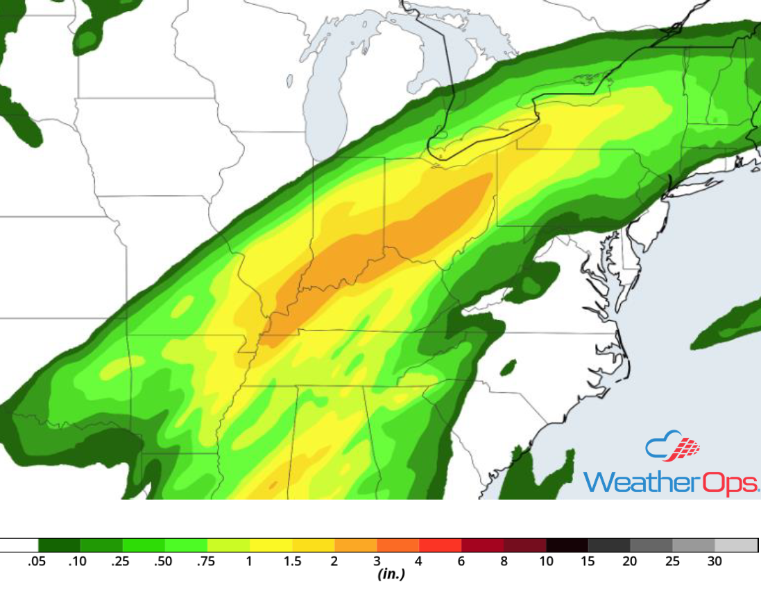
Rainfall Accumulation for Thursday
Thunderstorms for the East Coast on Friday
Thunderstorms are expected to be ongoing during the morning along a cold front moving eastward. As daytime heating and ample moisture allows instability to build, these storms could intensify with gusty winds and large hail the primary hazards. This activity should push offshore by late evening.
Major Cities in Region: Jacksonville, FL, Savannah, GA, Columbia, SC, Raleigh, NC, Norfolk, VA
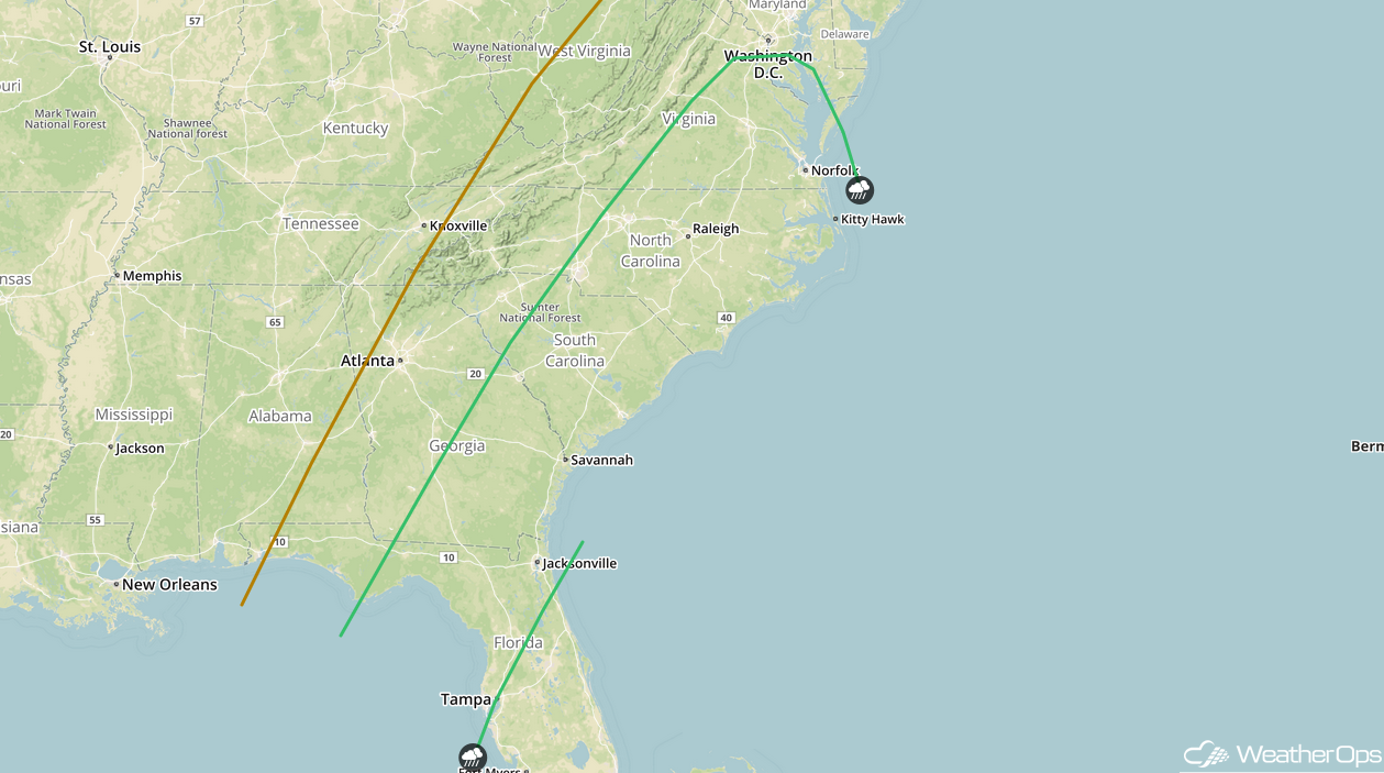
SPC Convective Outlook for Friday
Excessive Rainfall Friday across the Northeast
The cold front described above will move into the Northeast on Friday. With abundant moisture across the region, there will be a potential for excessive rainfall. Rainfall amounts will range 2-3 inches with locally higher amounts in excess of 4 inches. Areas that receive heavy rain on Thursday will be at the greatest risk for flooding and flash flooding.
Major Cities in Region: New York, NY, Albany, NY, Manchester, NH
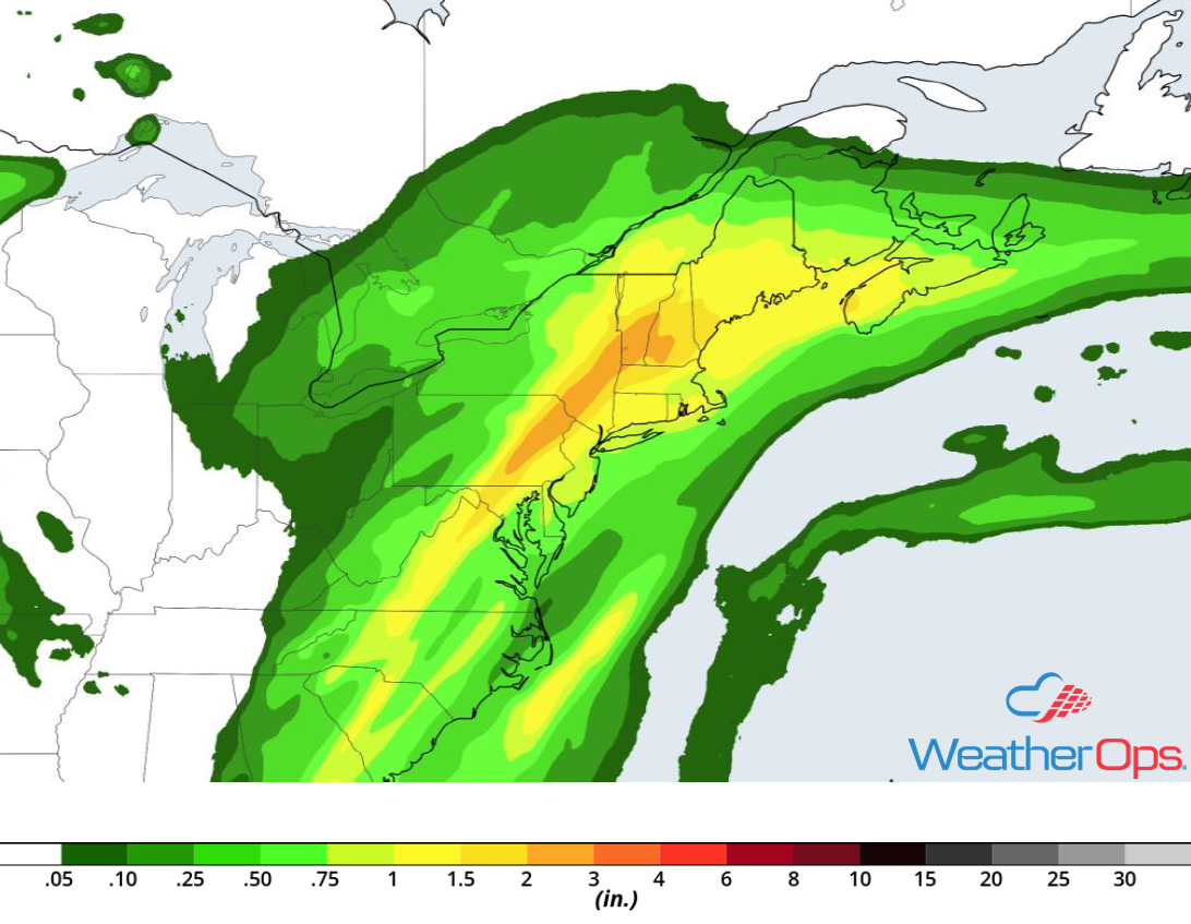
Rainfall Accumulation for Friday
Tropical Update
Hurricane Oscar is 690 miles east-northeast of Bermuda and is moving northeastward at 22 mph. A faster north-northeast to northeast motion is expected during the next few days. Maximum sustained winds are at 75 mph with higher gusts. Oscar will become an extratropical low over the north-central Atlantic by tonight. Although gradual weakening is expected during the next several days, Oscar is expected to remain a strong post-tropical cyclone over the north-central and northeastern Atlantic into the weekend.
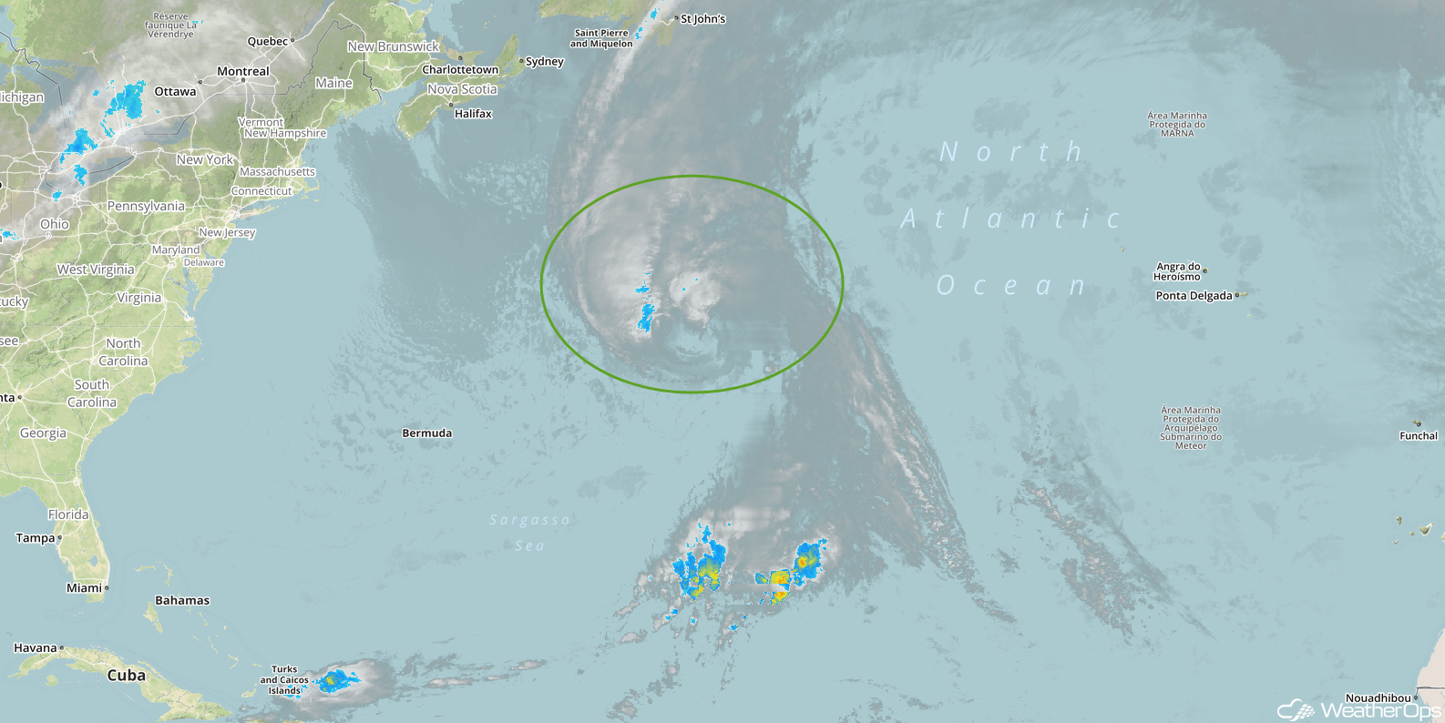
Enhanced Infrared Satellite
A Look Ahead
An area of low pressure will move into the Northern Plains on Saturday, bringing rain and snow to the Northern Plains and Upper Midwest. By Sunday, light rain will extend from the Great Lakes into east Texas. Snow is forecast across the Northern and Central Rockies. This snow will continue into Monday. Light to moderate rain may develop Monday along the coasts of Georgia and the Carolinas. Moderate to heavy rain may extend from the Great Lakes to the Tennessee Valley on Tuesday.


