by David Moran, on Oct 3, 2018 11:21:47 AM
An upper level low will allow for the development of thunderstorms across the Desert Southwest on Wednesday. This system may also pose a risk for excessive rainfall across the Great Basin. Thunderstorms are expected to develop from the Central Plains into the Upper Midwest as an area of low pressure moves across the region. Some of these storms may produce heavy to excessive rainfall across the Great Lakes.
- Thunderstorms for the Desert Southwest on Wednesday
- Excessive Rainfall Wednesday for the Great Basin
- Risk for Thunderstorms from the Central Plains into the Upper Midwest on Wednesday
- Potential for Excessive Rainfall Wednesday across the Great Lakes
- Snow across North Dakota Thursday and Friday
- Thunderstorm Potential Thursday from Northwest Oklahoma into the Texas Panhandle
- Thunderstorms from the Central Plains into the Midwest Friday
- Excessive Rainfall Friday from the Central Plains to the Midwest
- Tropical Update
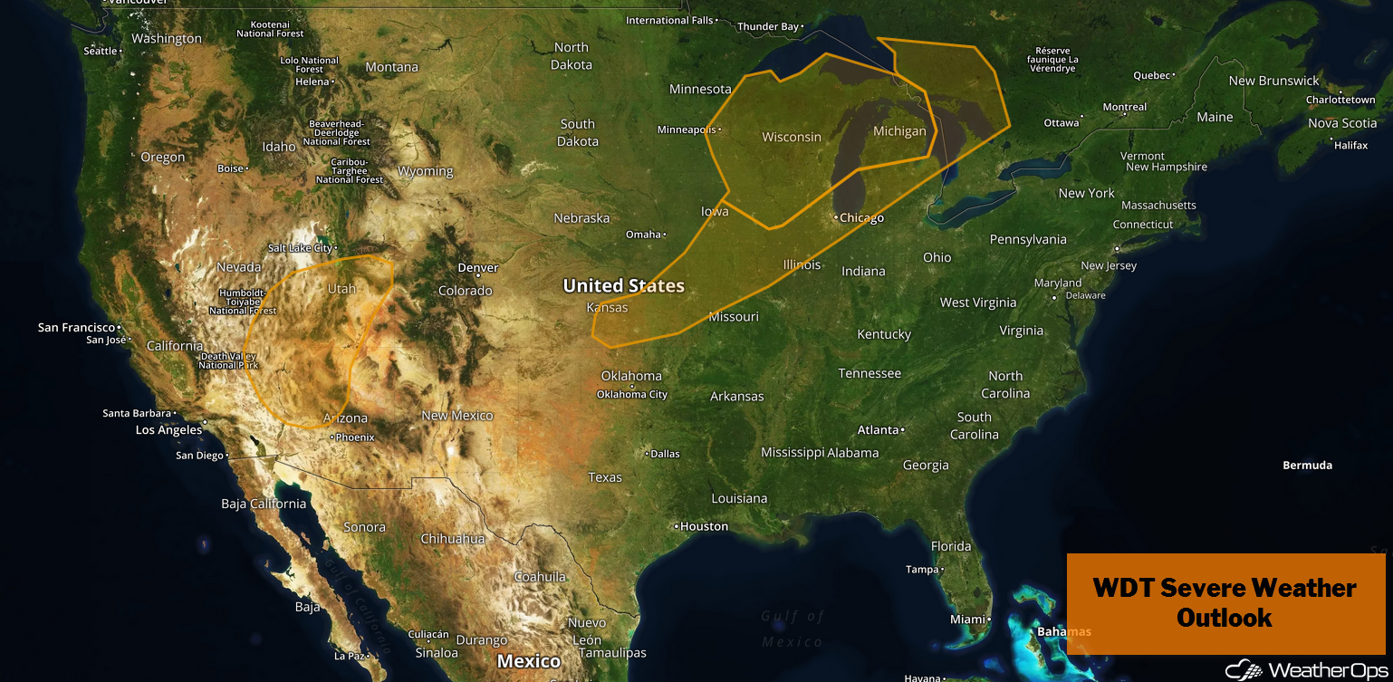
US Hazards
Thunderstorms for the Desert Southwest on Wednesday
An upper level system will move into the Great Basin region on Wednesday, allowing a potential for strong to severe thunderstorms over southern Nevada into Utah and Arizona. During the afternoon, isolated to widely scattered thunderstorms will develop with hail and damaging winds the primary hazards. By the early evening, the upper level low will move over the region; damaging winds will become the primary hazard as storms move eastward.
Major Cities in Region: Las Vegas, NV, St. George, UT, Flagstaff, AZ
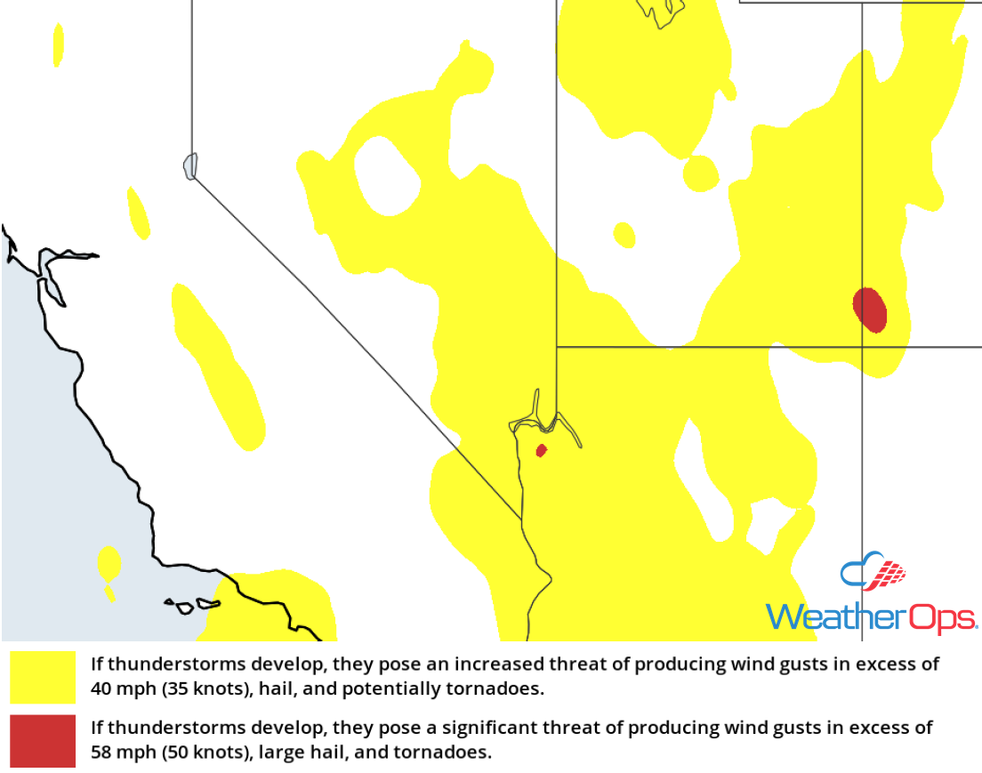
Thunderstorm Risk for Wednesday
Excessive Rainfall Wednesday for the Great Basin
In addition to the thunderstorms described above, there will be a potential for heavy to excessive rainfall. Rainfall totals will range 0.75-1.50 inch with locally higher amounts in excess of 2.00 inches.
Major Cities in Region: Las Vegas, NV
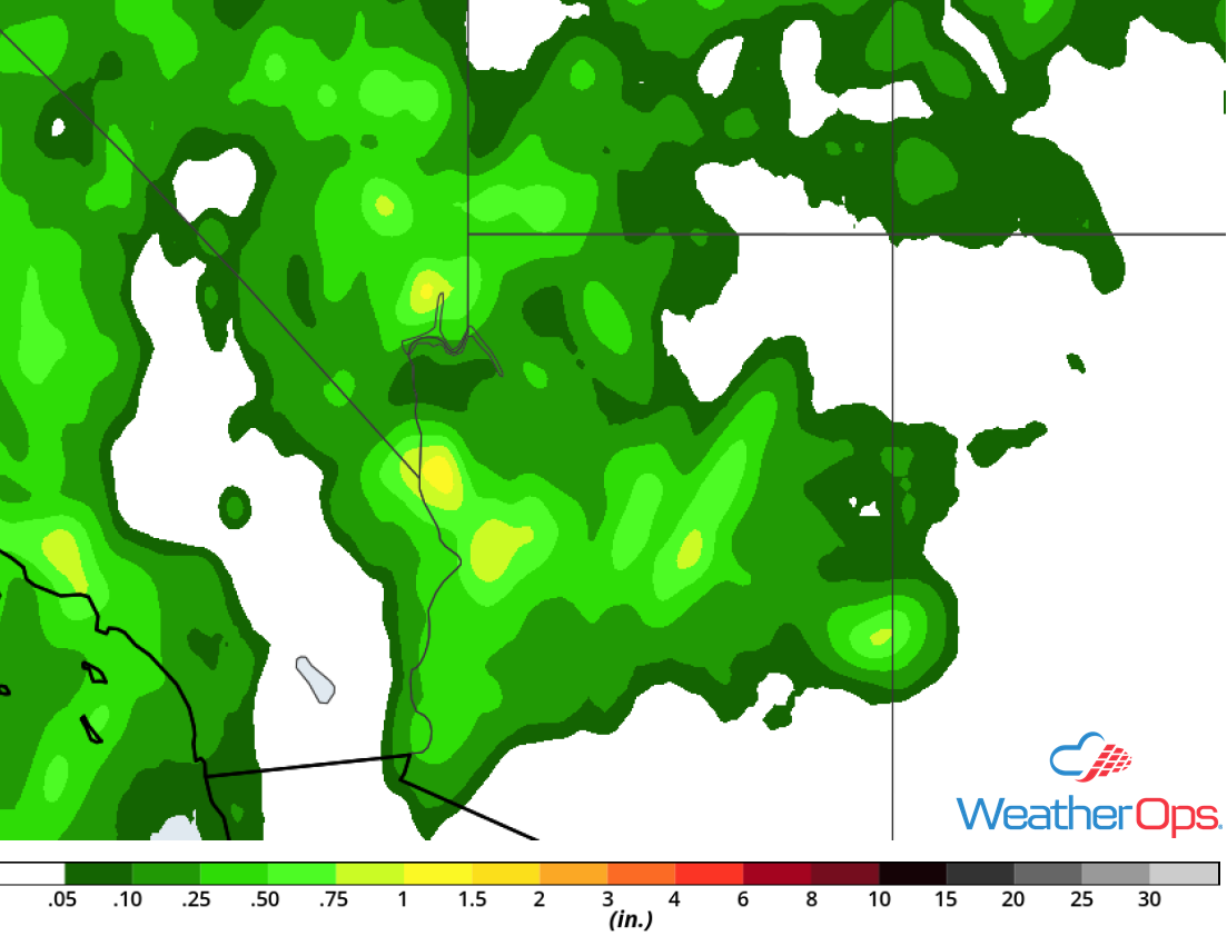
Rainfall Accumulation for Wednesday
Risk for Thunderstorms from the Central Plains into the Upper Midwest on Wednesday
Severe weather is likely on Wednesday across the Upper Midwest into the Central Plains as an area of low pressure moves through the region. The most likely area for severe thunderstorms will be across much of Wisconsin into southeast Minnesota and northeast Iowa. Storms will develop along the cold front and warm fronts associated with the area of low pressure during the afternoon and move eastward. Large hail, damaging winds, and tornadoes will all be potential hazards. Further south, more isolated to scattered activity is expected with large hail and damaging winds the primary hazards.
Major Cities in Region: Minneapolis, MN, Rochester, MN, Cedar Rapids, IA, Wausau, WI
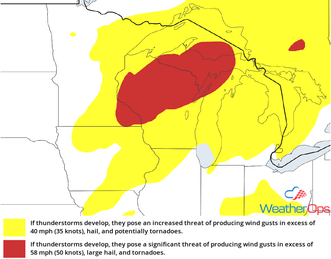
Thunderstorm Risk for Wednesday
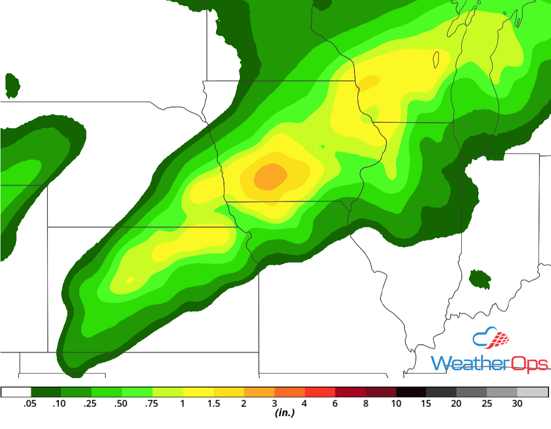
Potential for Excessive Rainfall Wednesday across the Great Lakes
A large area of thunderstorms is ongoing this morning across the Great Lakes and will continue through the morning hours. Rainfall accumulations of 1-2 inches are expected with the morning activity. By the late afternoon into the evening, a second round of thunderstorms is expected. An additional 1-2 inches will be possible, leading to a risk of flash flooding with the heaviest storms.
Major Cities in Region: Wausau, WI, Marquette, MI, Grand Rapids, MI
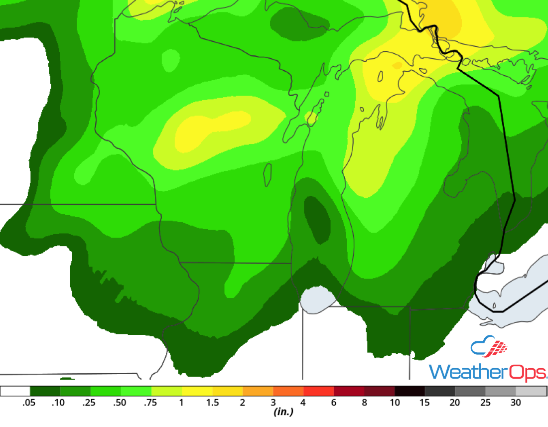
Rainfall Accumulation for Wednesday
Snow across North Dakota Thursday and Friday
An area of low pressure will develop over the Plains on Thursday and push moisture northward. North of the warm front, temperatures will be near or at freezing as rain begins. Rain will transition to snow over northern North Dakota. Snow accumulations of 2-4 inches with locally higher amounts are expected. Some light icing may occur as rain transitions to snow.
Major Cities in Region: Minot, ND, Bismarck, ND, Grand Forks, ND
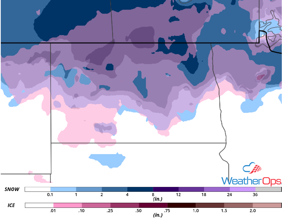
Snow and Ice Accumulation for Thursday and Friday
Thunderstorm Potential Thursday from Northwest Oklahoma into the Texas Panhandle
Scattered thunderstorms may develop along a stalled front over Northwest Oklahoma and into West Texas. Upper level winds combined with remnant outflow boundaries left behind from thunderstorms Wednesday night could provide an environment for an isolated severe thunderstorm or two. These storms will have a low risk of producing hail, damaging winds, and tornadoes.
Major Cities in Region: Woodward, OK, Elk City, OK
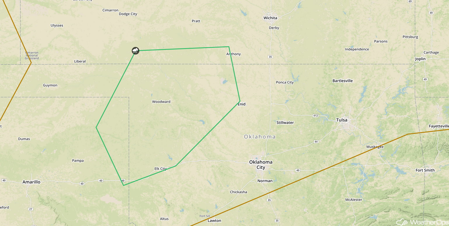
SPC Convective Outlook for Thursday
Thunderstorms from the Central Plains into the Midwest Friday
There will be a potential for strong to severe thunderstorms across portions of the Central Plains and into the Midwest on Friday along a stalled front. Activity will develop during the afternoon as an upper level trough moves across the region; large hail and damaging winds will be the primary hazards with these storms. Activity will increase in coverage and become widespread through the evening. Strong winds will become the primary hazard while storms remain nearly stationary.
Major Cities in Region: Woodward, OK, Wichita, KS, Topeka, KS, Kansas City, MO, Des Moines, IA, Cedar Rapids, IA
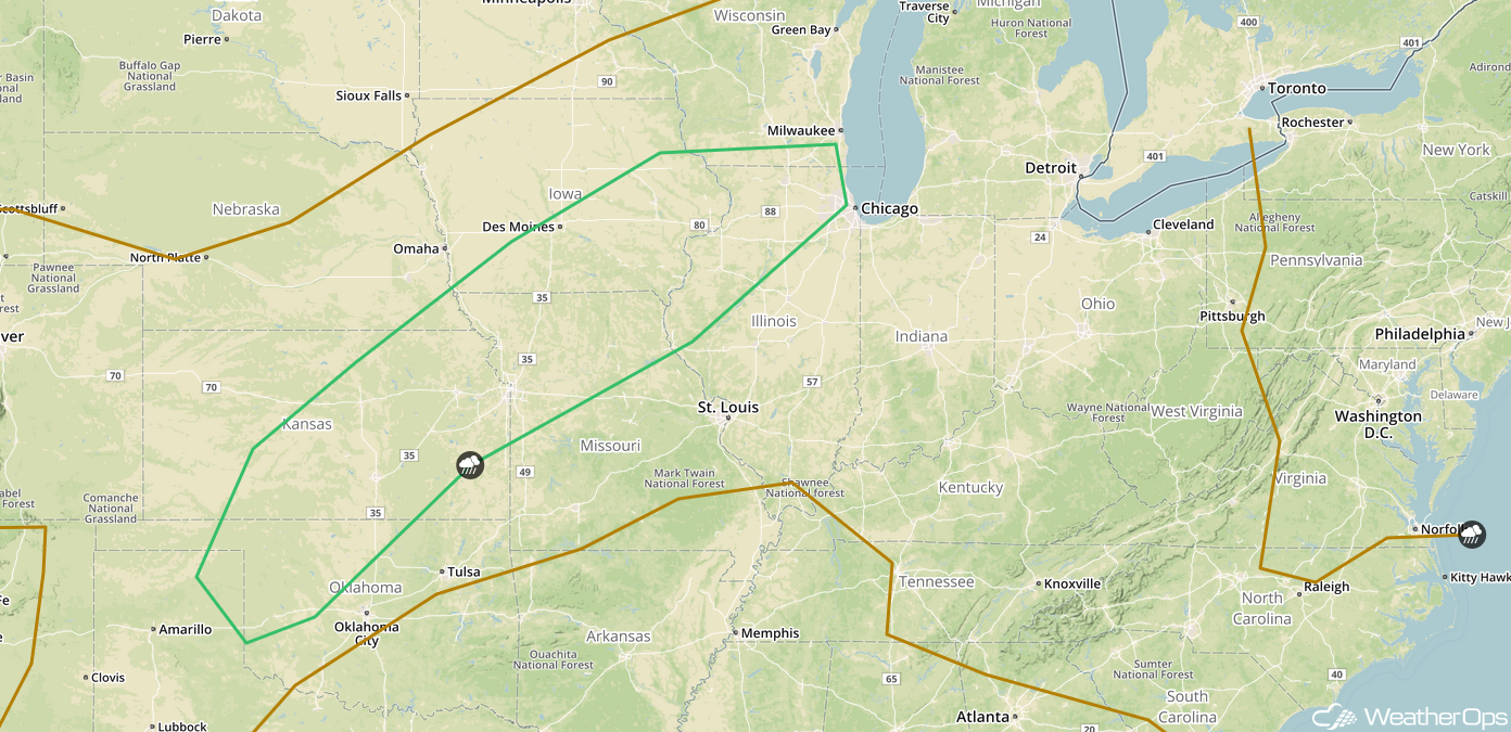
SPC Convective Outlook for Thursday
Excessive Rainfall Friday from the Central Plains to the Midwest
The thunderstorms described above will likely lead to a risk for excessive rainfall. Rainfall amounts of 1-2 inches with locally higher amounts in excess of 3 inches are expected, resulting in a potential for flash flooding.
Major Cities in Region: Des Moines, IA, Madison, WI, Green Bay, WI
Rainfall Accumulation for Friday
Tropical Update
Hurricane Leslie (green oval) is 510 miles east-southeast of Bermuda and is stationary. A northward motion is expected to begin tonight and continue through Friday night. A turn to the east is expected this weekend. Maximum sustained winds are near 80 mph with higher gusts. Some additional strengthening is expected during the next day or so, but a slow weakening trend is expected to begin on Friday.
Disorganized showers and thunderstorms over the central and southwestern Caribbean Sea (red oval) are associated with a broad area of low pressure. Some slow development may occur this weekend while the low moves across the northwestern Caribbean Sea.
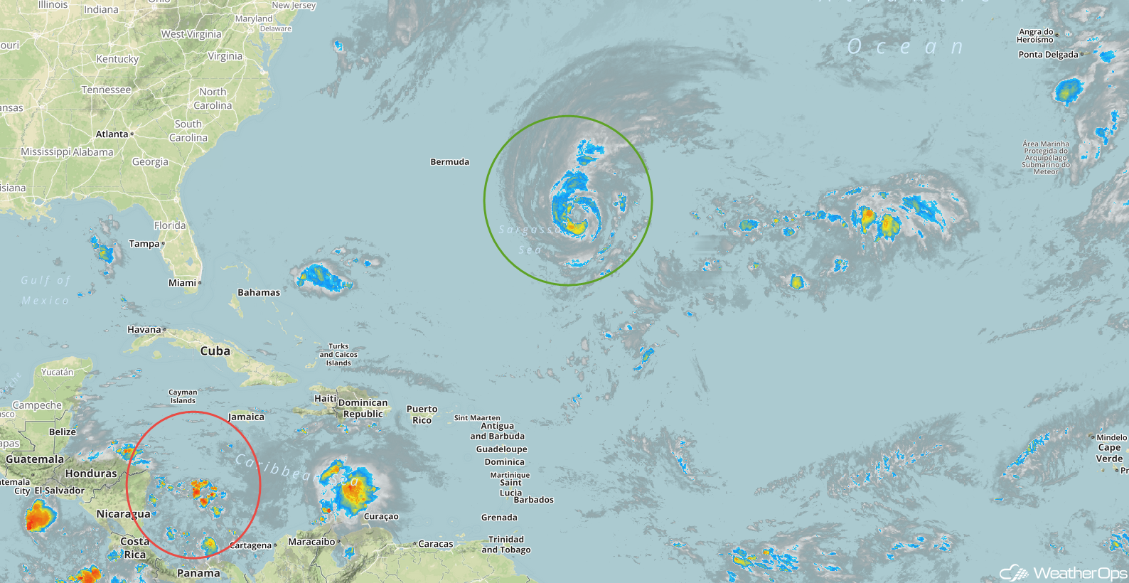
Enhanced Infrared Satellite
A Look Ahead
Heavy rain and thunderstorms will extend from the Southern High Plains into the Mid Mississippi Valley on Saturday ahead of a cold front. This activity will continue through Tuesday. Four day rainfall totals will range 4-6 inches with locally higher amounts in excess of 8 inches, leading to the potential for flooding.