


by David Moran, on May 9, 2018 11:04:57 AM
There will be a risk for showers and thunderstorms from the central Mississippi Valley into the Great Lakes on Wednesday as an upper level trough moves through the region. As a trough develops in the lee of the Rockies, thunderstorms may develop across western Kansas.
- Thunderstorms from the Central Mississippi Valley into the Great Lakes on Wednesday
- Potential for Thunderstorms Wednesday across Western Kansas
- Risk for Thunderstorms from the Central Appalachians to the Great Lakes on Thursday
- Thunderstorms Thursday from the Central Plains through the Central Mississippi Valley
- Thunderstorm Potential for the Central Plains on Friday
 US Hazards

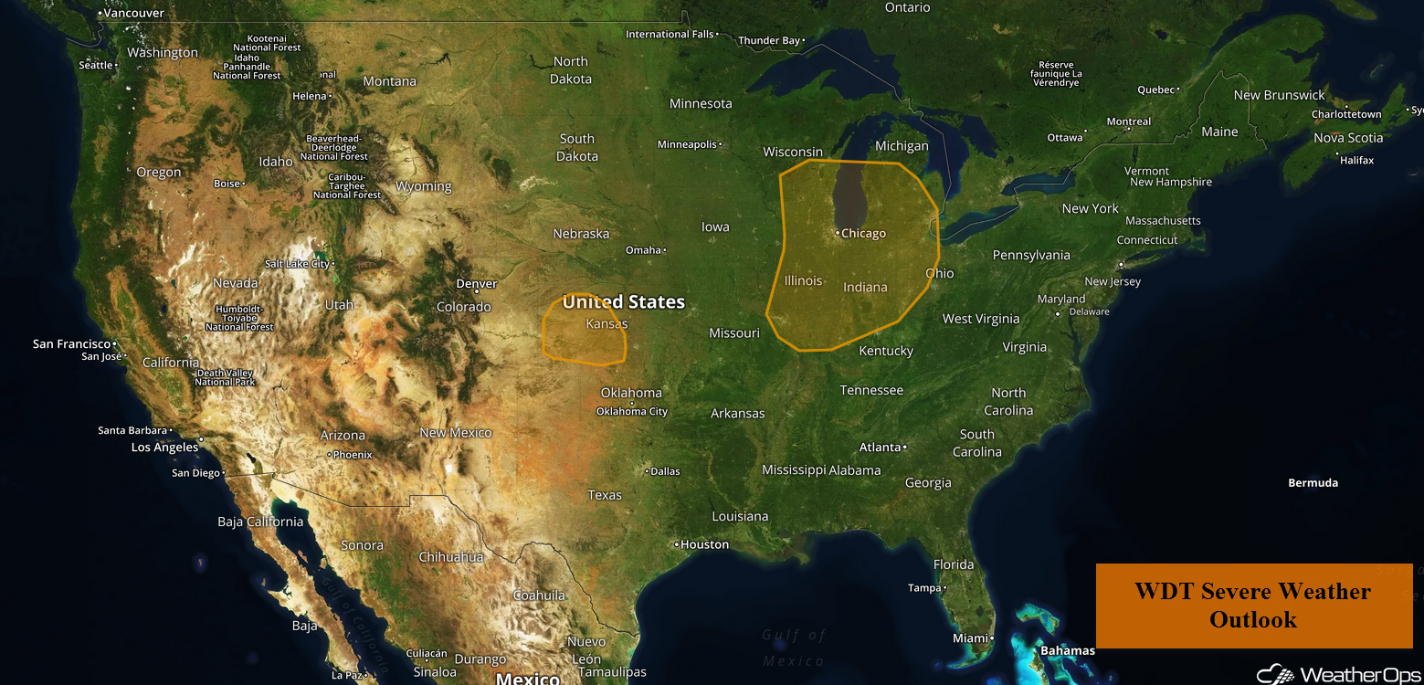
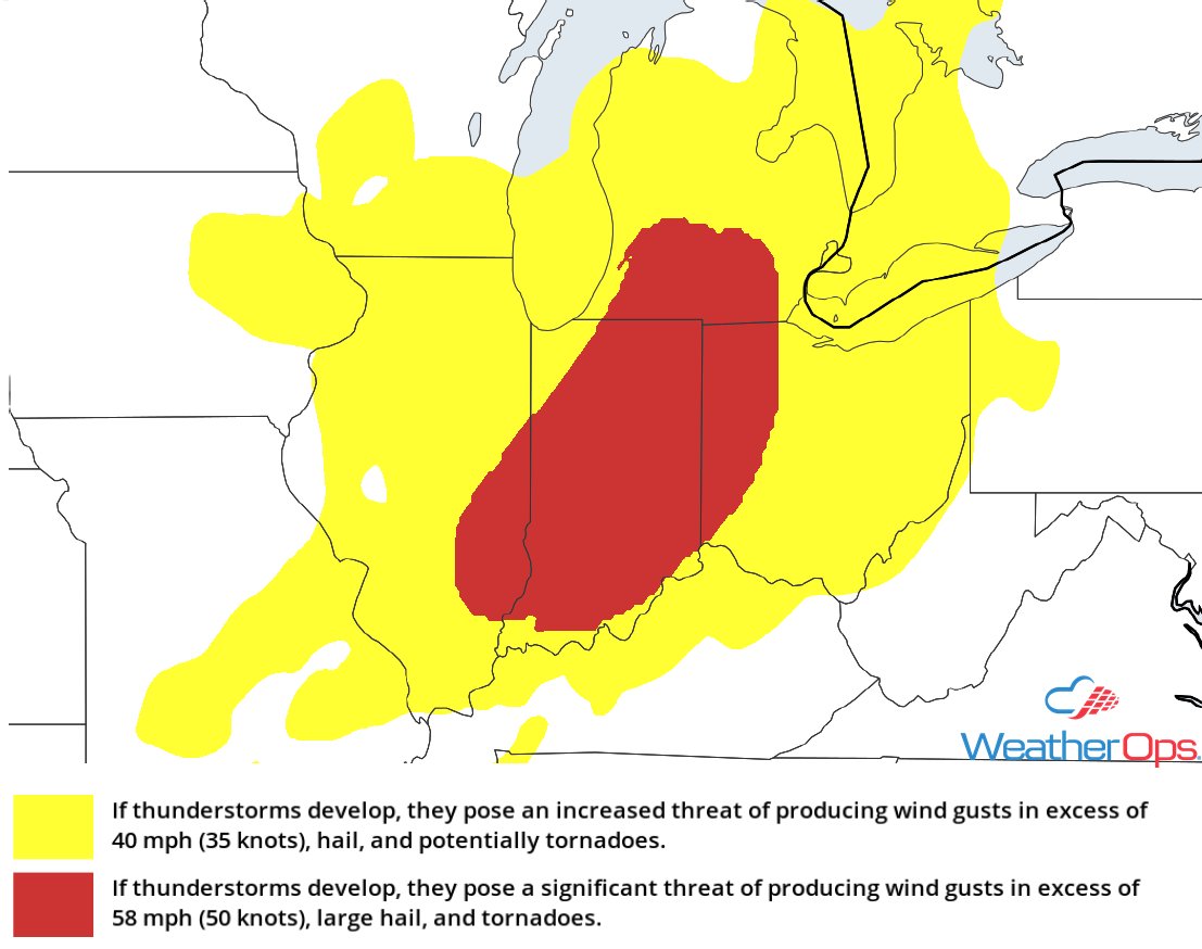
Thunderstorms from the Central Mississippi Valley into the Great Lakes on Wednesday
As an upper level low slowly moves across the region, the associated surface low will move from southern Minnesota into Michigan; as it does, the surface low will intensify. To the the east of the low, southerly winds will bring in very moist air; coupled with daytime heating, instability is expected to build. As the cold front associated with the surface low approaches, strong to severe thunderstorms are expected to develop. Damaging winds and large hail will be the primary hazards, but an isolated tornado or two cannot be ruled out.
Major Cities in Region: St. Louis, MO, Milwaukee, WI, Chicago, IL, Indianapolis, IN, Detroit, MI
 Thunderstorm Risk for Wednesday
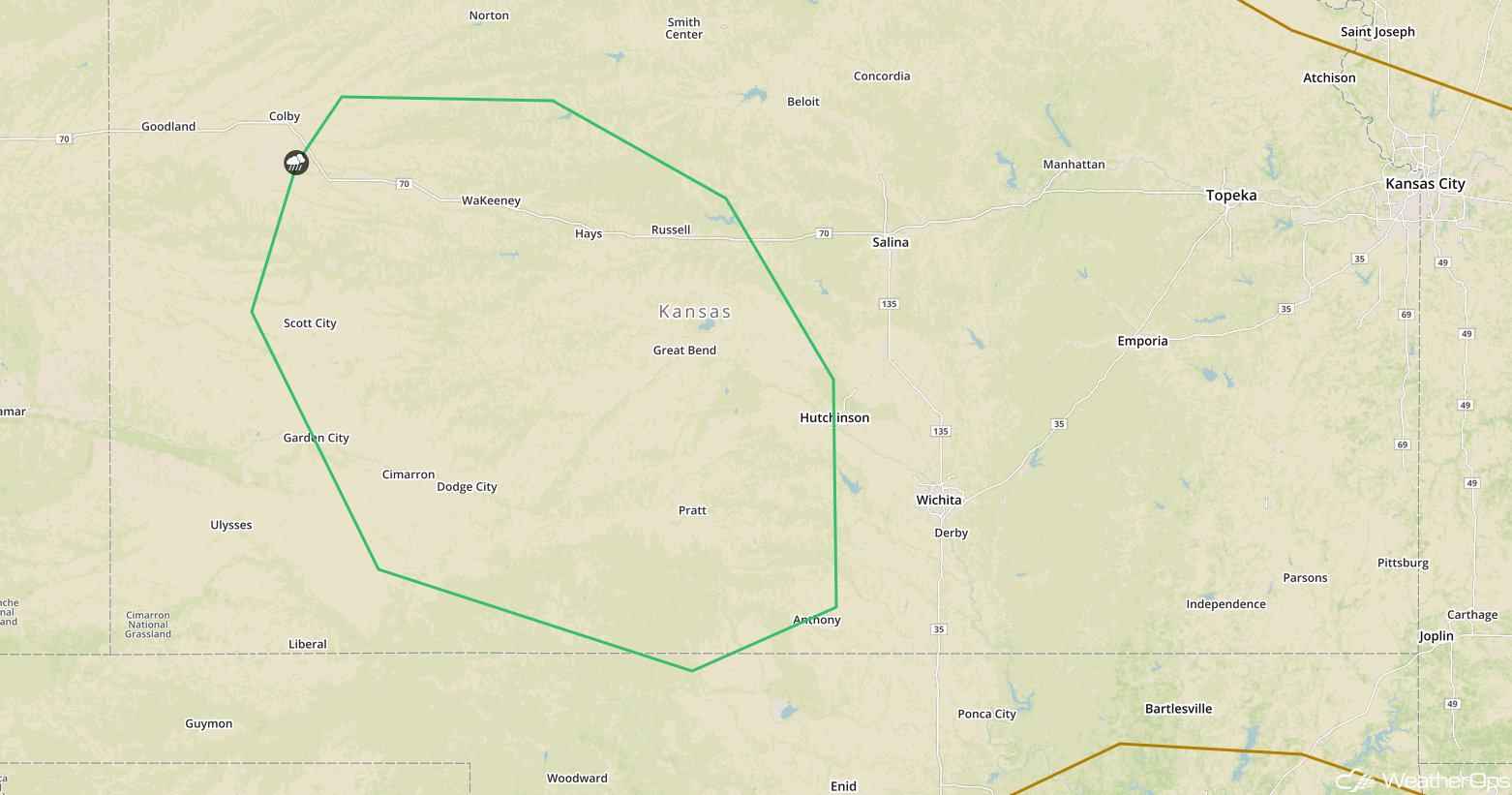
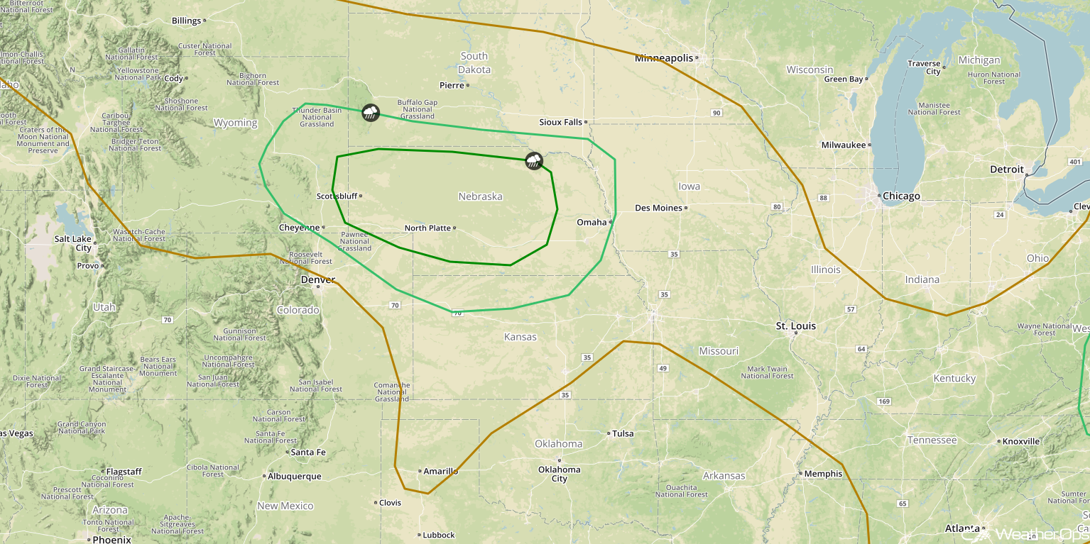
Potential for Thunderstorms Wednesday across Western Kansas
As an area of low pressure develops in the lee of the Rockies, southerly flow will begin this afternoon. Upslope flow, combined with weak upper level forcing, may be sufficient for the development of a few thunderstorms, some of which could become severe. Damaging winds will be the primary hazard with these storms, but a few instances of large hail cannot be ruled out.
Major Cities in Region: Dodge City, KS, Great Bend, KS, Hutchinson, KS
 SPC Convective Outlook for Wednesday
Risk for Thunderstorms from the Central Appalachians to the Great Lakes on Thursday
A weakening upper level trough will be moving across the Northeast on Thursday. At the surface a cold front will extend eastward. By early Thursday afternoon, it should extend from the eastern Great Lakes southwestward into Tennessee and Kentucky. Although storms will likely be ongoing from the night before, additional thunderstorms may develop ahead of the front during the afternoon. Damaging winds will be the primary hazard. Thunderstorms should dissipate after sunset.
Major Cities in Region: Pittsburgh, PA, Buffalo, NY, Syracuse, NY, Washington, DC, Philadelphia, PA
 SPC Convective Outlook for Thursday
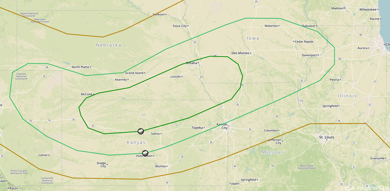
Thunderstorms Thursday from the Central Plains through the Central Mississippi Valley
An area of low pressure will develop in the lee of the Rockies on Thursday. This will allow a warm front to develop to the east of the low. Instability will build as daytime heating increases and as a result, strong to severe thunderstorms are forecast to develop. Damaging winds and large hail will be the primary hazards. These thunderstorms may form a large cluster and continue eastward into the nighttime hours. Damaging winds will then become the primary hazard.
Major Cities in Region: Scottsbluff, NE, North Platte, NE, Omaha, NE, Des Moines, IA, Cedar Rapids, IA
 SPC Convective Outlook for Thursday
Thunderstorm Potential for the Central Plains on Friday
An area of low pressure will continue to develop in the lee of the Rockies on Friday. A frontal boundary will extend eastward across Kansas and Nebraska, providing a focus for the development of thunderstorms. Large hail and damaging winds will be the primary threats. The storm threat will shift eastward overnight.
Major Cities in Region: Grand Island, NE, Topeka, KS, Omaha, NE, Des Moines, IA, Davenport, IA
 SPC Convective Outlook for Friday
A Look Ahead
Showers and thunderstorms will continue across portions of the Plains on Saturday in association with the area of low pressure described above. This activity will move into the Ohio River Valley and Mid Atlantic on Sunday. Going into early next week, showers and thunderstorms may develop across portions of Oklahoma and Texas as an area of low pressure develops in the lee of the Rockies.
This is just a brief look at current weather hazards. We can provide you site-specific weather forecast information for the purpose of protecting your personnel and assets and to assess your weather risk. Try a 7-day demo right away and learn how timely precision weather information can enhance your bottom line.
