


by David Moran, on May 30, 2018 11:10:23 AM
Thunderstorms may develop across portions of Nevada, Idaho, Montana and Wyoming on Wednesday ahead of a cold front. An upper level disturbance will allow for the development of thunderstorms across the Western and Central Plains. As the remnants of Alberto continues to track northward, thunderstorms are expected across portions of the Great Lakes region. Excessive rainfall is expected across the Midwest, Ohio Valley, and Great Lakes. The risk for excessive rainfall will continue for portions of Alabama, Georgia, and the Appalachians.
- Thunderstorms for Portions of Nevada, Idaho, Montana, and Wyoming on Wednesday
- Potential for Thunderstorms Wednesday across the Western and Central Plains
- Thunderstorm Potential for the Great Lakes on Wednesday
- Excessive Rainfall Wednesday across the Midwest, Ohio Valley, and Great Lakes
- Risk for Excessive Rainfall for Alabama, Georgia, and the Appalachians on Wednesday
- Thunderstorms Thursday for Idaho, Montana, and the Dakotas
- Excessive Rainfall for Montana and Idaho on Thursday
- Thunderstorm Potential Thursday from the Central Plains into the Ohio and Tennessee Valleys
- Thunderstorms for the Northern Plains on Friday
- Risk for Excessive Rainfall Friday across the Northern Plains
 US Hazards

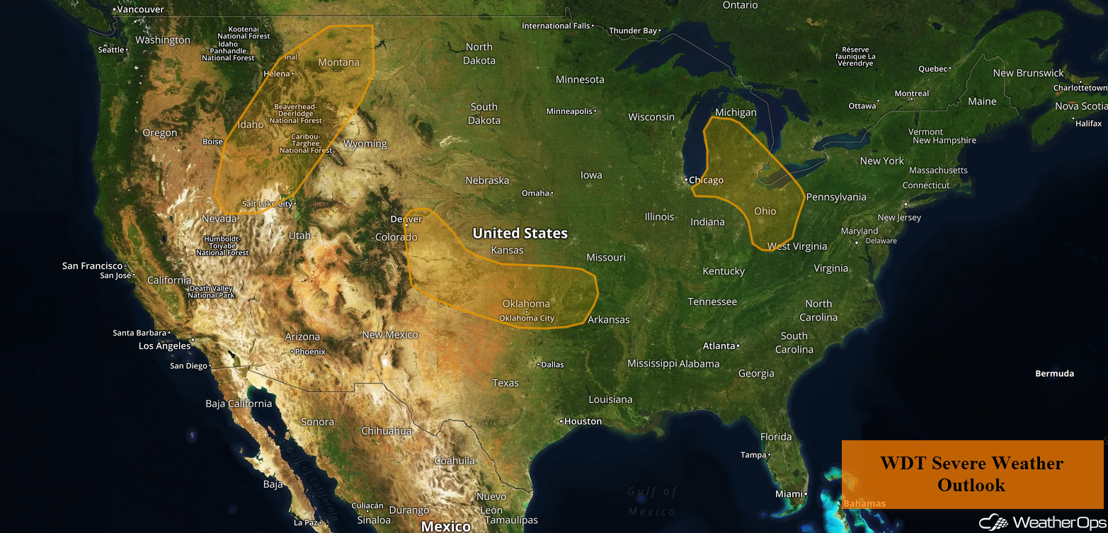
Thunderstorms for Portions of Nevada, Idaho, Montana, and Wyoming on Wednesday
Low level moisture and instability will increase along and ahead of a cold front from the late morning through the afternoon and early evening. Scattered showers and thunderstorms, a few severe, are likely to develop along and ahead of the front by late morning or midday. Storm coverage will increase through the day. Damaging winds will be the primary hazard with these storms. A few strong storms may continue through the evening before ending overnight.
Major Cities in Region: Twin Falls, ID, Pocatello, ID, Idaho Falls, ID, Butte, MT, Helena, MT, Great Falls,, MT, Billings, MT
 Thunderstorm Risk for Wednesday
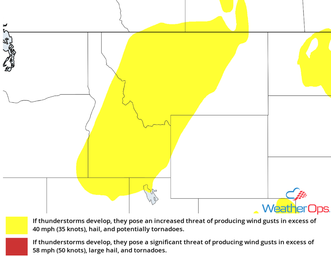
Potential for Thunderstorms Wednesday across the Western and Central Plains
An upper level disturbance will aid in the development of isolated severe thunderstorms along and immediately east of the Rockies during the early afternoon. Storms will shift eastward into the western High Plains during the late afternoon and early evening. Late tonight, a few isolated severe storms are expected to move into southern and eastern portions of Kansas and Oklahoma. Damaging winds and large hail will be the primary hazards, but an isolated tornado cannot be ruled out.
Major Cities in Region: Guymon, OK, Dodge City, KS, Oklahoma City, OK, Wichita, KS, Tulsa, OK
 Thunderstorm Risk for Wednesday
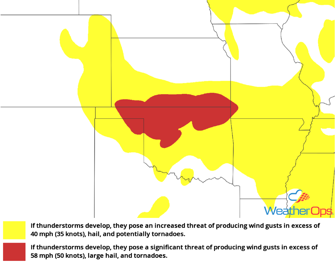
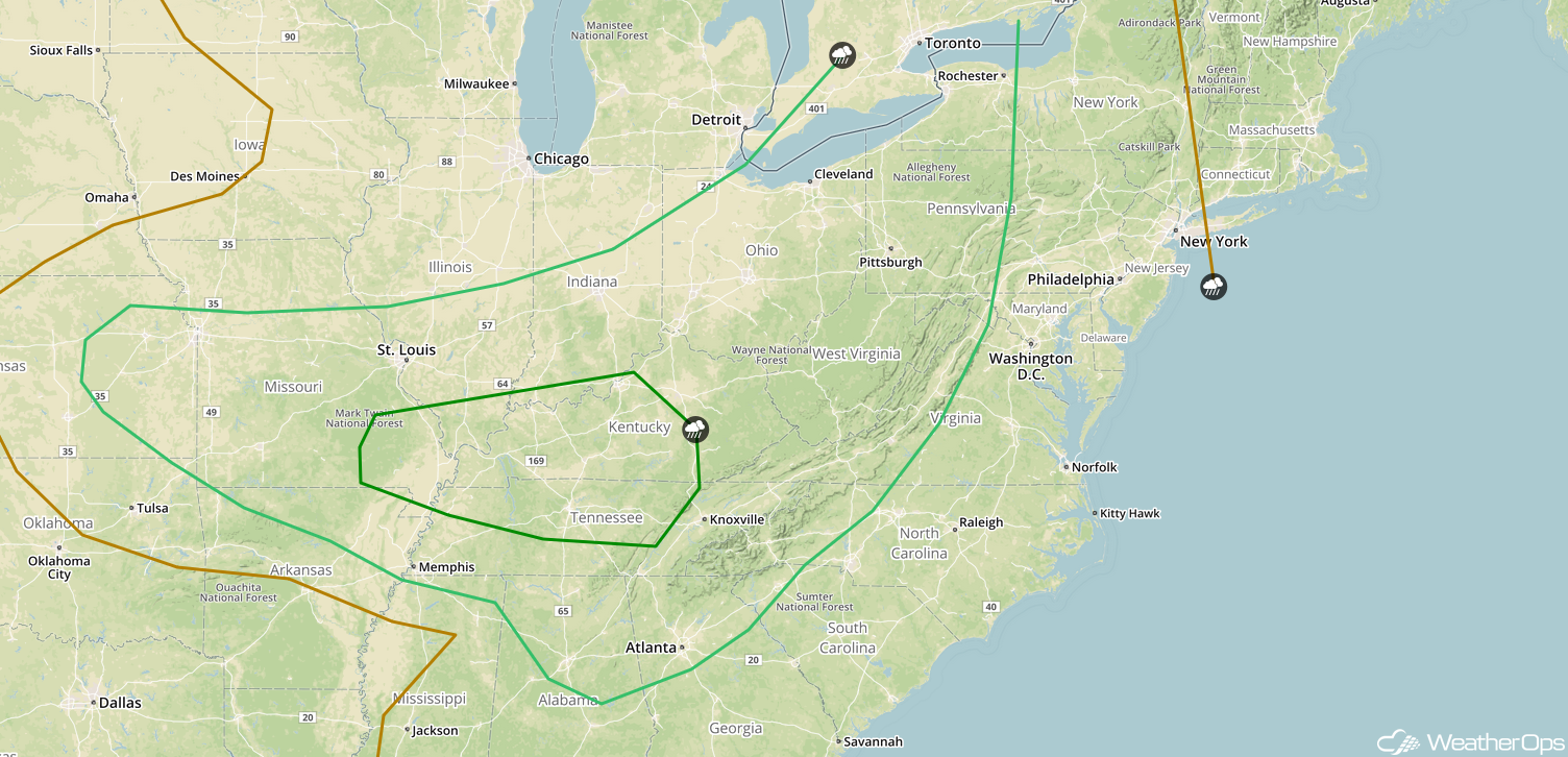
Thunderstorm Potential for the Great Lakes on Wednesday
The broad remnant center of Alberto is expected to track into southern and central Indiana by mid-afternoon. Combined with daytime heating, scattered thunderstorms are expected to develop. Damaging winds and isolated tornadoes will be the primary hazards with these storms.
Major Cities in Region: Indianapolis, IN, Detroit, MI, Columbus, OH
 Thunderstorm Risk for Wednesday
Excessive Rainfall Wednesday across the Midwest, Ohio Valley, and Great Lakes
A large moisture plume associated with the remnant low of Alberto is expected to move into the region. Abnormally high moisture content will allow afternoon and evening thunderstorms to produce heavy rainfall. Rainfall totals of 1-2 inches with locally higher amounts in excess of 3 inches are forecast, allowing the potential for isolated flash flooding. Hourly rainfall rates may exceed 1-2 inches per hour at times.
Major Cities in Region: Green Bay, WI, South Bend, IN, Grand Rapids, MI
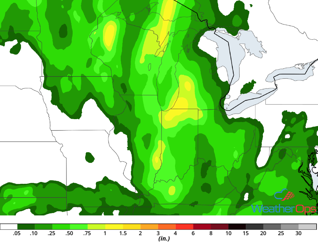 Rainfall Accumulation for Wednesday
Risk for Excessive Rainfall for Alabama, Georgia, and the Appalachians on Wednesday
After several days of heavy rainfall, additional heavy rainfall is expected as the remnants of Alberto continue to move northward. This rainfall will allow for continued flooding with an additional 1-2 inches forecast as moisture continues to be drawn northward from the Gulf of Mexico.
Major Cities in Region: Huntsville, AL, Atlanta, GA, Greenville, SC
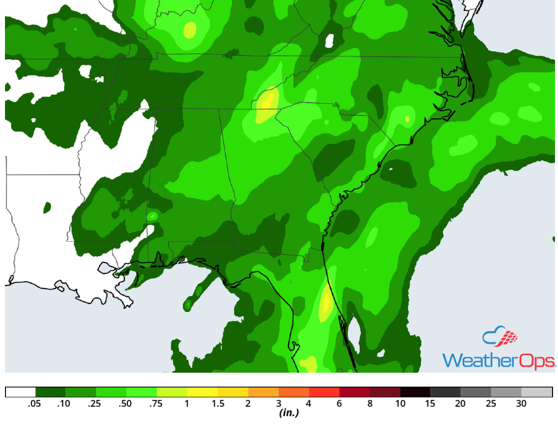 Rainfall Accumulation for Wednesday
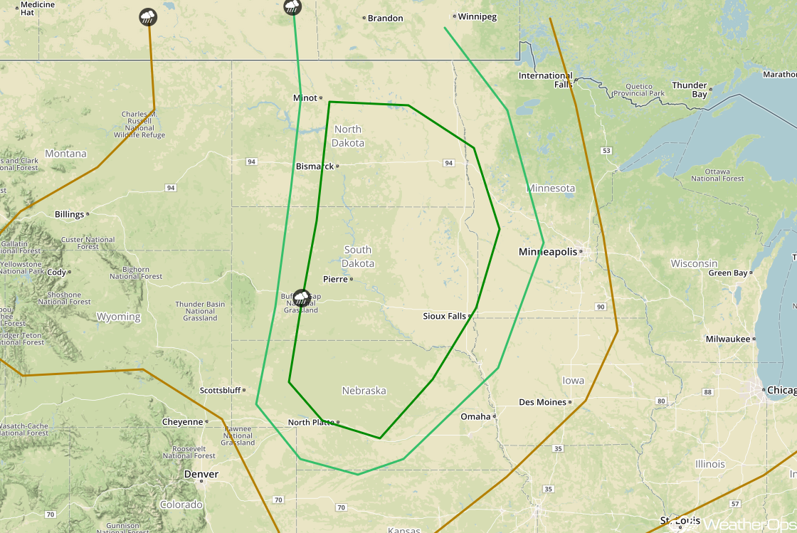
Thunderstorms Thursday for Idaho, Montana, and the Dakotas
The overall pattern across the Pacific Northwest and western High Plains will change very little into Thursday. Southwesterly winds aloft ahead of an upper level disturbance will provide adequate wind shear needed for organized thunderstorm development. In addition, instability will remain in place along and east of a nearly stationary front. As a result, redevelopment of isolated strong thunderstorms is forecast on Thursday. Damaging winds and large hail will be the primary hazards with these storms.
Major Cities in Region: Billings, MT, Glasgow, MT, Glendive, MT, Minot, ND
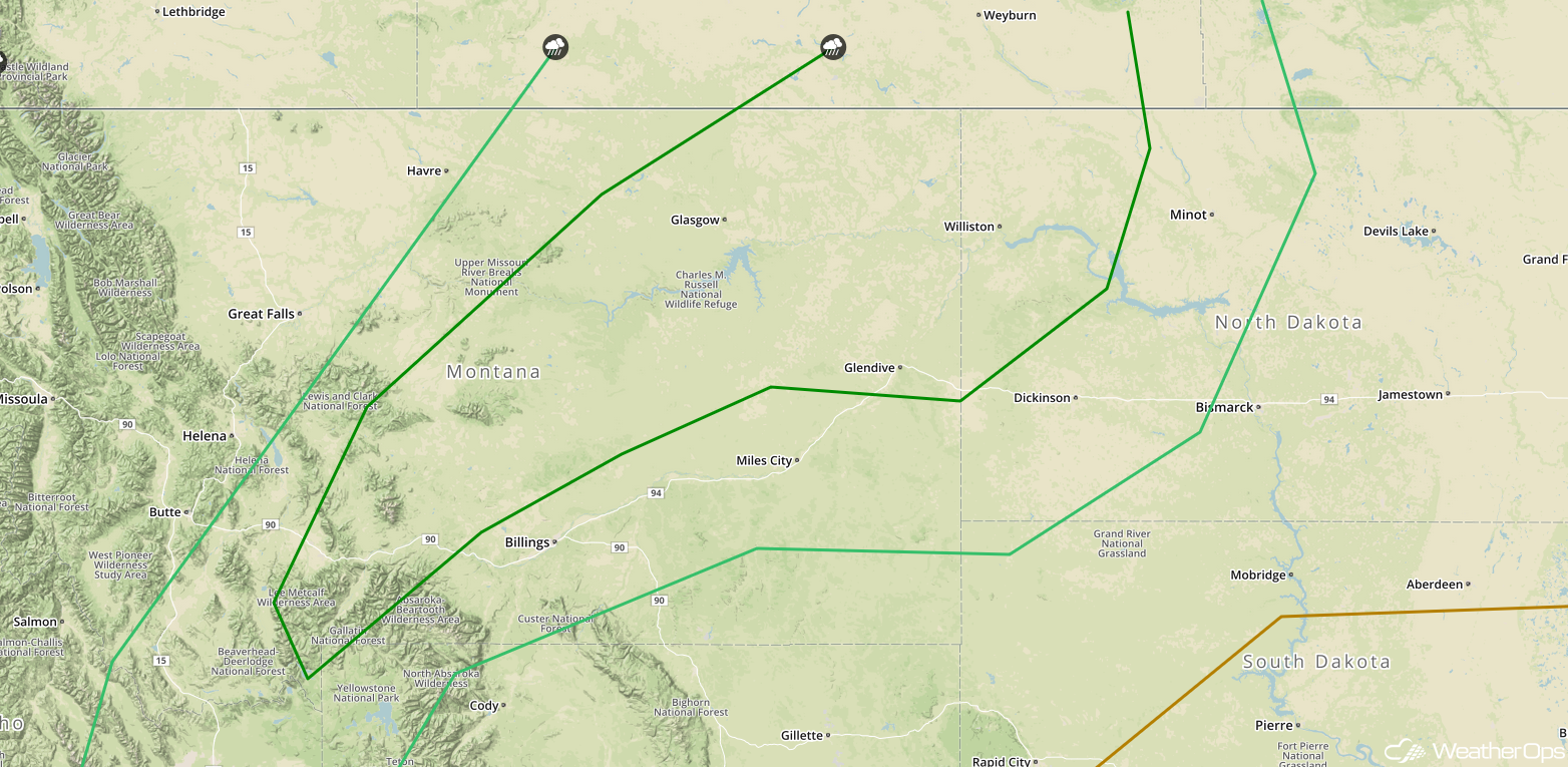 SPC Convective Outlook for Thursday
Excessive Rainfall for Montana and Idaho on Thursday
A slow-moving cold front will produce several rounds of widely scattered, occasionally heavy, thunderstorm activity. Previous rains combined with the potential for additional heavy rain will allow for the risk of localized flash flooding within the higher terrain through Thursday. Additional rainfall amounts of 0.50-1.00 inch are forecast.
Major Cities in Region: Boise, ID, Missoula, MT, Butte, MT. Helena, MT, Great Falls, MT
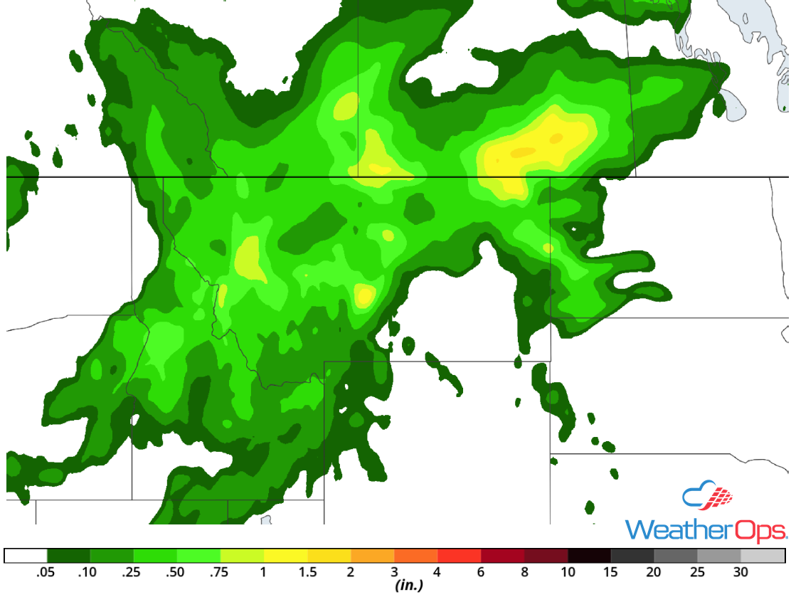 Rainfall Accumulation for Thursday
Thunderstorm Potential Thursday from the Central Plains into the Ohio and Tennessee Valleys
A warm, moist, and fairly unstable air mass will dominate much of the central and eastern US by Thursday morning. Strong westerly winds in the upper levels of the atmosphere along and southeast of a frontal boundary will allow for the development of scattered thunderstorms by the early afternoon. Storms will likely begin to develop across Indiana and Ohio during the early afternoon and increase in coverage from the Central Plains into Kentucky through the early evening. Damaging winds and large hail will be the primary hazards with these storms.
Major Cities in Region: Topeka, KS, Kansas City, MO, St. Louis, MO, Memphis, TN, Nashville, TN, Atlanta, GA, Cleveland, OH, Pittsburgh, PA
 SPC Convective Outlook for Thursday
Thunderstorms for the Northern Plains on Friday
Strong to severe thunderstorms will likely develop along and ahead of a cold front Friday afternoon and evening. The associated area of low pressure will track across southern Saskatchewan and Manitoba while the cold front moves across the Dakotas and Nebraska. A few thunderstorms will likely produce heavy rainfall as low level moisture surges northward. Increasing southwesterly winds aloft in association with an upper level disturbance approaching from the Northwest will provide the necessary shear for organized thunderstorms. Large hail and damaging winds will be the primary hazards, but a few isolated tornadoes cannot be ruled out.
Major Cities in Region: North Platte, NE, Pierre, SD, Sioux Falls, SD, Bismarck, ND, Fargo, ND
 SPC Convective Outlook for Friday
Risk for Excessive Rainfall Friday across the Northern Plains
Showers and thunderstorms will likely develop along and ahead of a cold front from Nebraska northward into North Dakota and western Minnesota on Friday. In addition to the threats mentioned above, there will also be the potential for excessive rainfall. Widespread rainfall totals of 1-2 inches with locally higher amounts in excess of 3 inches are forecast. Most of this rainfall will likely occur within a 2-3 hour period, leading to flash flooding,
Major Cities in Region: North Platte, NE, Pierre, SD, Bismarck, ND, Minot, ND, Fargo, ND
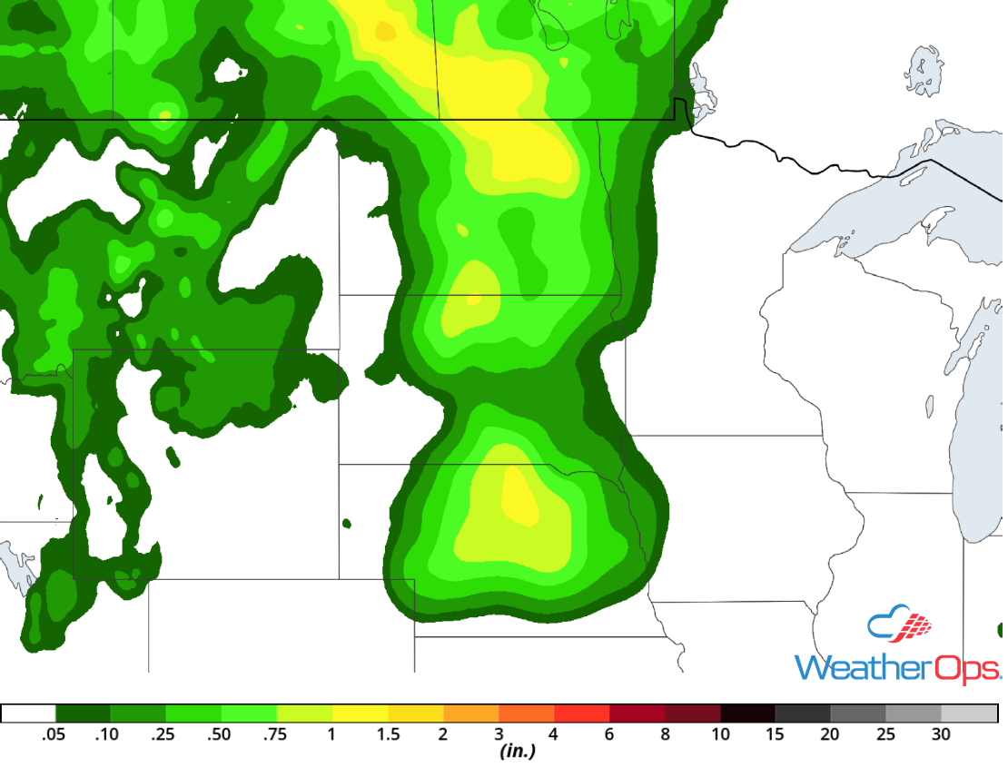 Rainfall Accumulation for Friday
A Look Ahead
Showers and thunderstorms will track eastward across the Northern Plains into the Great Lakes ahead of a cold front on Saturday. Light showers may develop across portions of the Southeast into the Tennessee Valley on Sunday. By Monday, thunderstorms may develop across northern Florida as a cold front moves southward. Going into Tuesday, thunderstorms will extend from the Great Lakes into the Plains.
This is just a brief look at current weather hazards. We can provide you site-specific weather forecast information for the purpose of protecting your personnel and assets and to assess your weather risk. Try a 7-day demo right away and learn how timely precision weather information can enhance your bottom line.
