


by David Moran, on May 23, 2018 11:11:35 AM
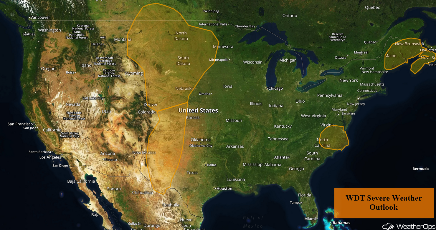
Thunderstorms will continue for portions of Maine through early Wednesday afternoon as a cold front pushes offshore. Across the Central US, thunderstorms are forecast as an area of low pressure moves across the region. A cold front approaching the Mid Atlantic will be the focus for thunderstorm development this afternoon and evening.
- Thunderstorms Continuing Wednesday across Portions of Maine
- Thunderstorms across the Central US on Wednesday
- Risk for Thunderstorms Wednesday across the Mid Atlantic
- Thunderstorm Potential Thursday for the Northern Plains and Upper Mississippi Valley
- Thunderstorms for the Upper Great Lakes and Central Plains Friday
- Tropical Update
 US Hazards

Thunderstorms Continuing Wednesday across Portions of Maine
Showers and thunderstorms will continue across portions of Maine through the early afternoon. A few thunderstorms may produce severe winds before the front pushes offshore during the afternoon hours.
Major Cities in Region: Augusta, ME, Bangor, ME, Caribou, ME
 WDT Severe Weather Outlook
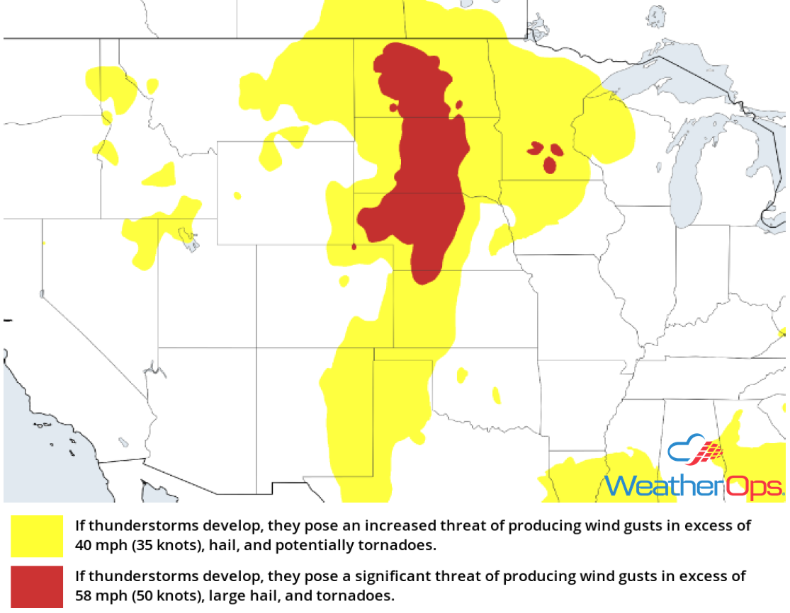
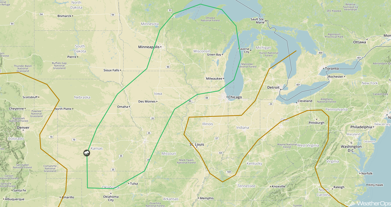
Thunderstorms across the Central US on Wednesday
A developing area of low pressure will move across the Central US today, with widespread thunderstorm development expected from the Northern High Plains southward into the Texas Panhandle. Thunderstorms will likely begin developing during the late afternoon and early evening as moisture increases. As thunderstorms develop, damaging winds and large hail will be the primary hazards. Activity will weaken after dark.
Major Cities in Region: Odessa, TX, Lubbock, TX, Amarillo, TX, Goodland, KS, North Platte, NE, Pierre, SD, Bismarck, ND, Minot, ND
 Thunderstorm Risk for Wednesday
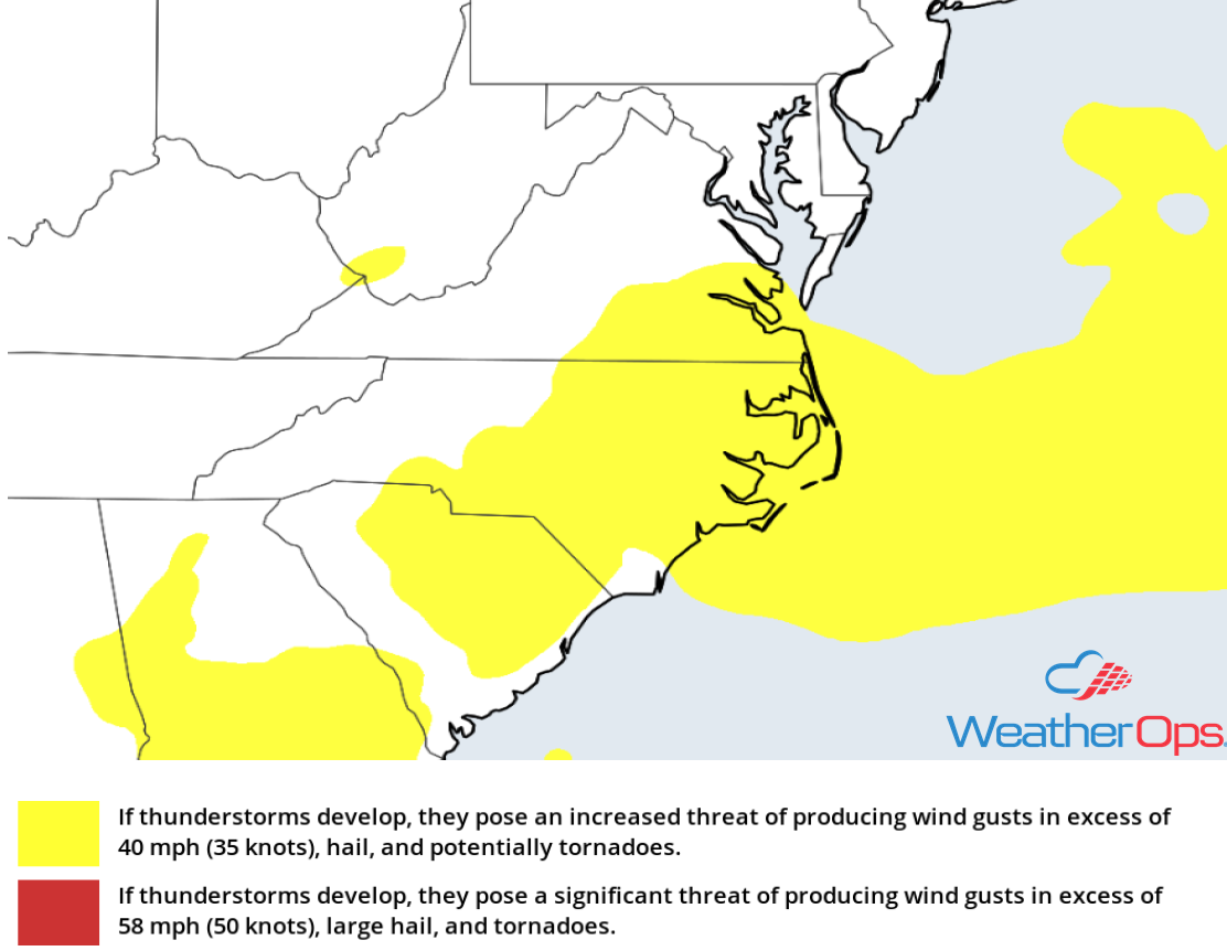
Risk for Thunderstorms Wednesday across the Mid Atlantic
A southeastward moving cold front will approach the Mid Atlantic today, with thunderstorm development likely during the afternoon. Plentiful moisture ahead of the front will allow for the development of strong to severe thunderstorms capable of large hail and damaging winds.
Major Cities in Region: Raleigh, NC, Norfolk, VA
 Thunderstorm Risk for Wednesday
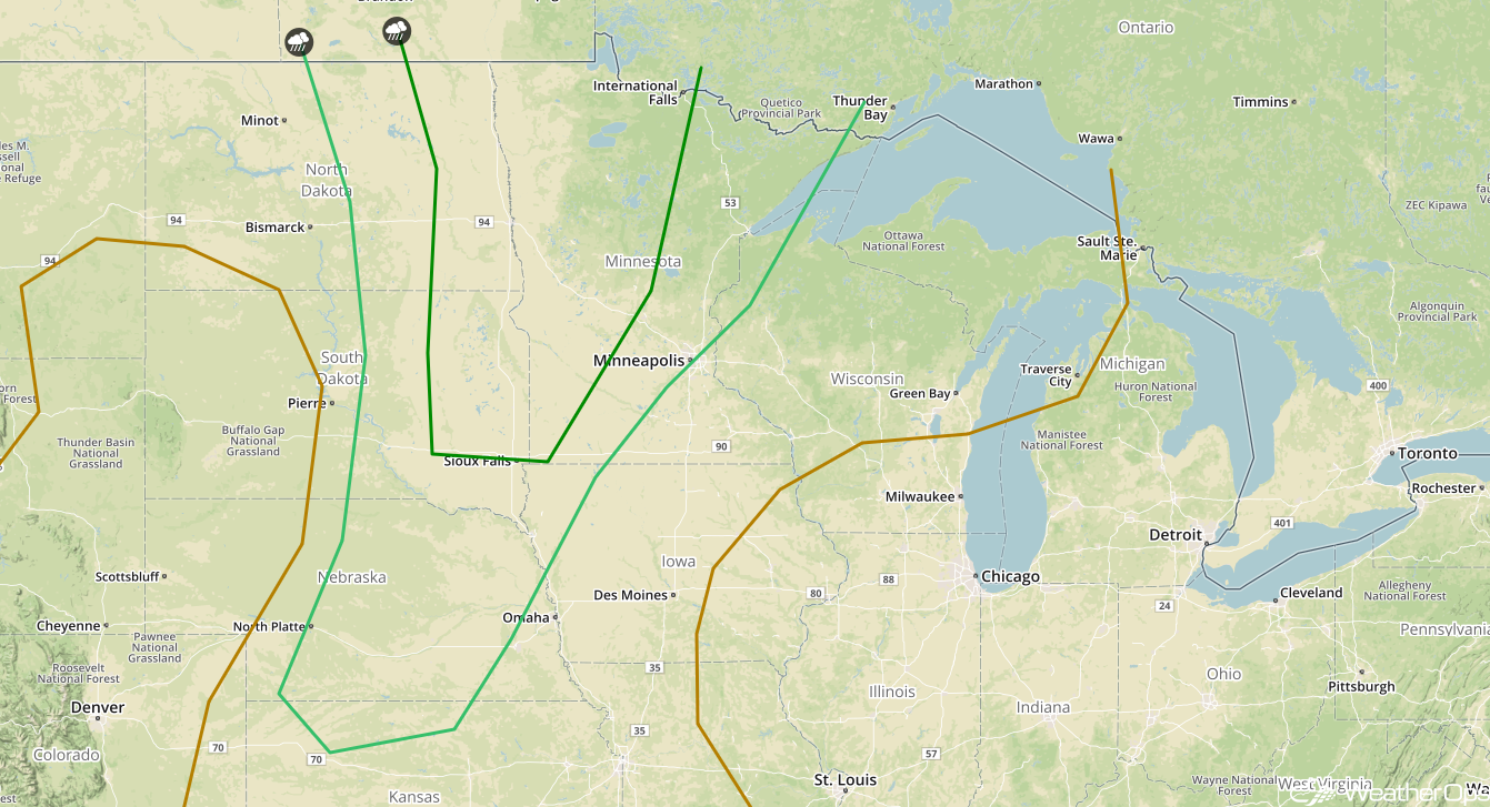
Thunderstorm Potential Thursday for the Northern Plains and Upper Mississippi Valley
An upper level trough is forecast to move across the region on Thursday, providing the forcing for the development of thunderstorms. At the surface, an area of low pressure and its associated frontal boundaries will be the focus for thunderstorm development. During the evening, a low level jet will intensify allowing clusters of thunderstorms to spread into the Upper Mississippi Valley. Strong winds will be the primary hazard with these storms.
Major Cities in Region: North Platte, NE, Sioux Falls, SD, Fargo, ND, Minneapolis, MN
 SPC Convective Outlook for Thursday
Thunderstorms for the Upper Great Lakes and Central Plains Friday
An area of low pressure will continue to move eastward, allowing for chance of thunderstorms of thunderstorms from the Upper Great Lakes into the Central Plains on Friday. Thunderstorms that are expected to develop Thursday night may be ongoing during the morning. However, additional thunderstorms are expected to develop during the afternoon as increased moisture and daytime heating increase instability ahead of a cold front. Damaging winds and large hail will be the primary hazards with these storms.
Major Cities in Region: Wichita, KS, Omaha, NE, Kansas City, MO, Des Moines, IA, Green Bay, WI, Milwaukee, WI
 SPC Convective Outlook for Friday
Tropical Update
A broad area of low pressure centered near the northeastern coast of Belize continues to produce a large area of cloudiness and showers extending from the northwestern Caribbean Sea across Cuba and into the Florida Straits. Little development is expected during the next couple of days due to strong upper level winds and the proximity to the Yucatan Peninsula. However, environmental conditions are forecast to become more conducive for development. A subtropical or tropical depression could develop this weekend over the central or eastern Gulf of Mexico. Regardless of development, locally heavy rain is forecast across western Cuba and the Cayman Islands during the next few days. Over the weekend, the heavy rain threat will shift northward across much of Florida and the northern Gulf Coast.
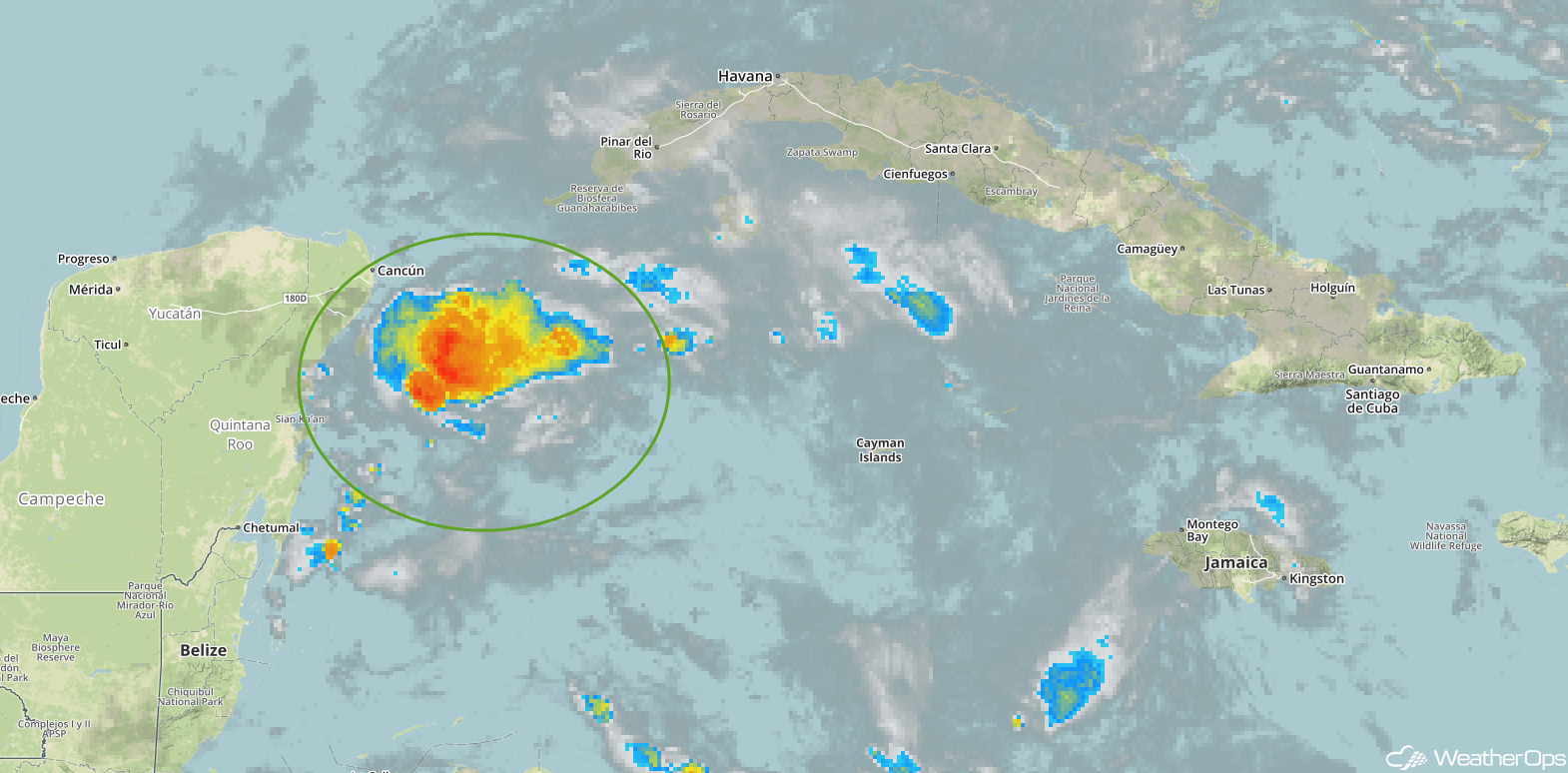 Enhanced Infrared Tropical Satellite
A Look Ahead
While there is still some discrepancy among models, confidence is increasing that the low described above will track northward through the central or eastern Gulf of Mexico late this weekend into the weekend. This track would support rainfall amounts in excess of 5 inches across portions of the Southeast. Elsewhere, showers and thunderstorms are forecast across much of the eastern US on Saturday as a cold front moves eastward. By Sunday, thunderstorms may develop across the Northern Plains as an area of low pressure moves across the region.
This is just a brief look at current weather hazards. We can provide you site-specific weather forecast information for the purpose of protecting your personnel and assets and to assess your weather risk. Try a 7-day demo right away and learn how timely precision weather information can enhance your bottom line.
