


by David Moran, on Mar 14, 2018 11:35:52 AM
Snow will continue across the Northeast on Wednesday as an area of low pressure continues to move northward. Thunderstorms may develop over portions of the Great Basin on Wednesday in association with an area of low pressure.
- Continued Snow for the Northeast Wednesday and Thursday
- Thunderstorms Wednesday across the Great Basin
- Snow for the Northern High Plains on Thursday
- Potential for Freezing Rain and Snow Friday into Saturday across the Central Plains
- Risk for Thunderstorms for the Lower Mississippi Valley Friday
 US Hazards

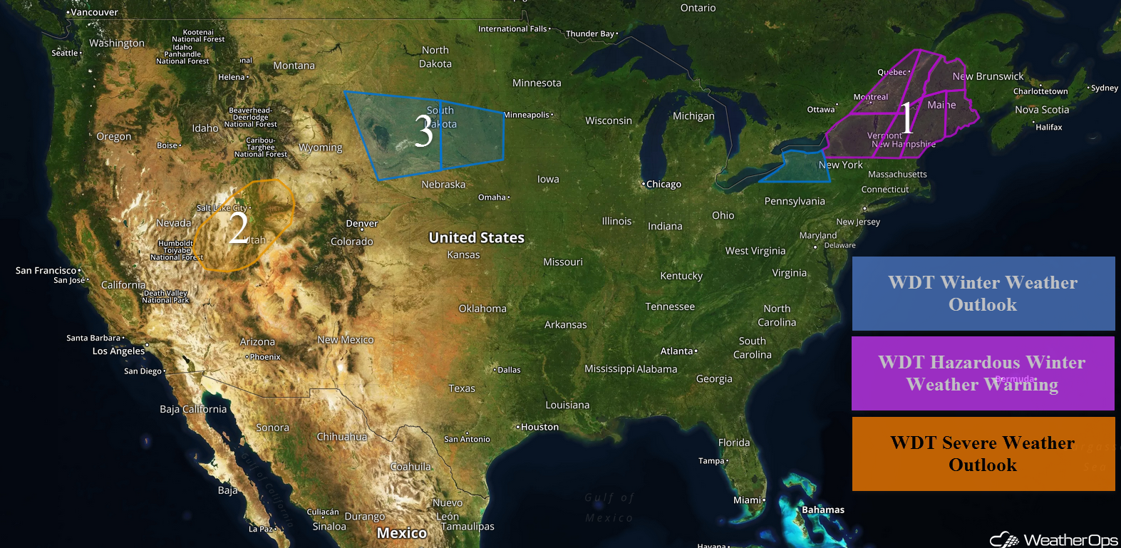
Continued Snow for the Northeast Wednesday into Thursday
Snow will continue across the Northeast through Thursday as the Nor'Easter impacting the region weakens and moves northward. Snow will end from south to north through the day on Thursday. Additional snowfall accumulations of 5-9 inches are expected. Winds will range 15-20 mph with gusts in excess of 30 mph.
Major Cities in Region: Buffalo, NY, Burlington, VT, Portland, ME, Augusta, ME, Bangor, ME, Caribou, ME
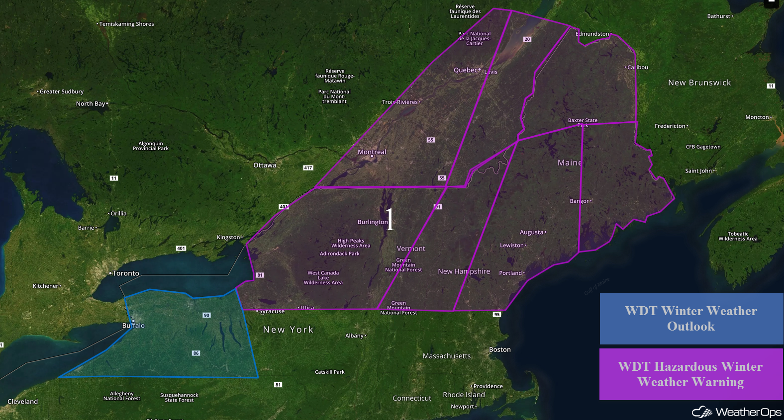 Region 1
Thunderstorms Wednesday across the Great Basin
A cold front will be tracking southeastward across the Great Basin throughout much of the day today. Ahead of the front, daytime heating will allow instability to build. With ample moisture and wind shear in place, showers and thunderstorms will develop along and ahead of the cold front with some storms becoming strong to severe. Large hail and damaging winds will be the primary hazards with these storms. Activity is expected to weaken later this evening with the loss of daytime heating.
Major Cities in Region: Ely, NV, Salt Lake City, UT
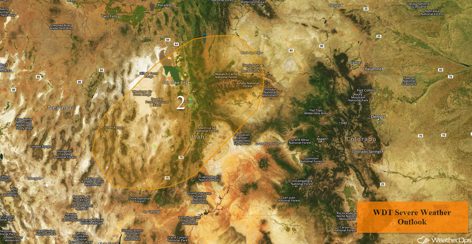 Region 2
Snow for the Northern High Plains on Thursday
Snow is forecast for the Northern High Plains on Thursday as an area of low pressure moves over the region. Snowfall accumulations of 8-12 inches are expected through Thursday evening. In addition, ice accumulations up to 0.10 inch are forecast in the lower elevations.
Major Cities in Region: Butte, MT, Helena, MT
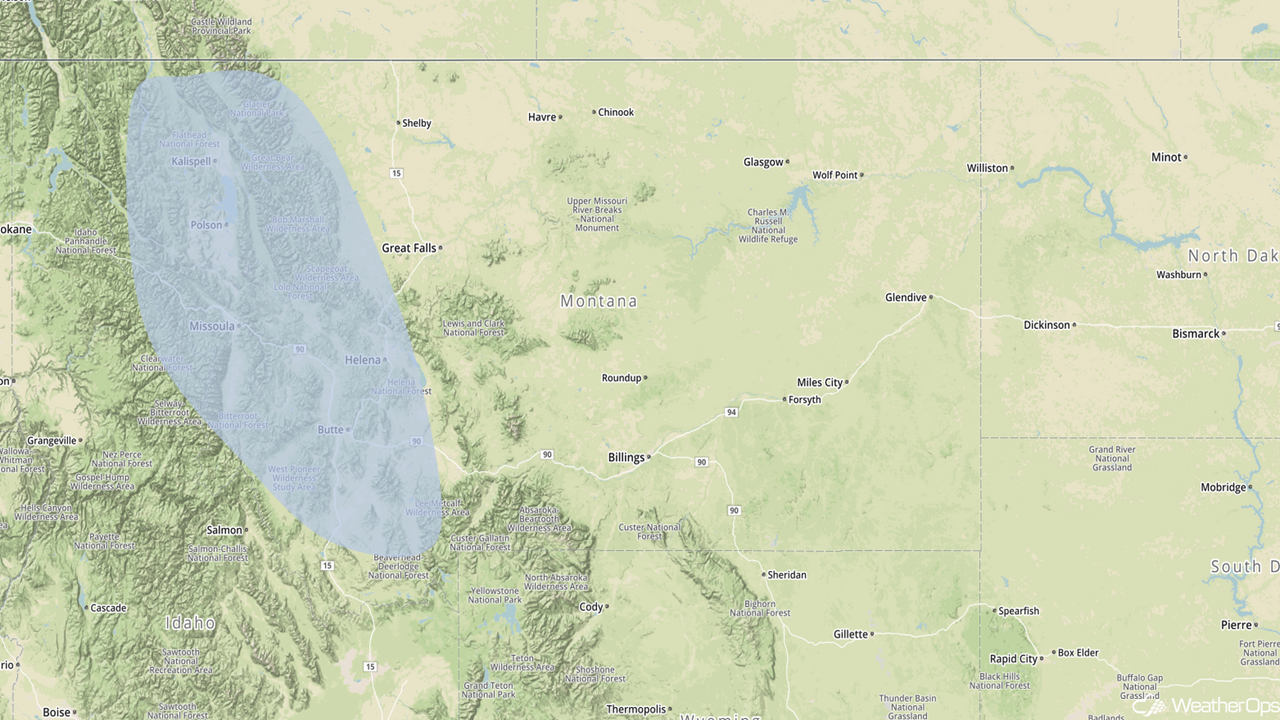 Snowfall Risk Outline for Thursday
Potential for Freezing Rain and Snow Friday into Saturday across the Central Plains
As the upper level system described above continues to move eastward on Friday, freezing rain and snow are expected across portions of the Plains. The heaviest snow is currently forecast across northwestern Nebraska and southwestern South Dakota where snowfall accumulations will range 6-8 inches with locally higher amounts in excess of 10 inches. Across western and central North Dakota, 4-8 inches are forecast. In addition, sleet and freezing rain is forecast for extreme southern South Dakota and northern Nebraska. Ice accumulations up to .25 inch are expected. Winds of 25-35 mph will allow for blowing snow and reduced visibilities.
Across central and eastern South Dakota into southern Minnesota, snow accumulations will range 3-6 inches with locally higher amounts in excess of 8 inches are forecast. Ice accumulations will range 0.1-0.3 inch. Further south across western and central Iowa, up to half an inch of freezing rain is expected.
Major Cities in Region: Rapid City, SD, Pierre, SD, Sioux Falls, SD, Des Moines, IA, Waterloo, IA
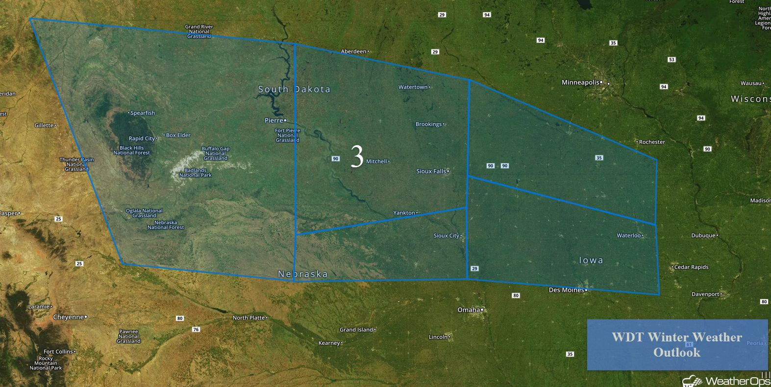 Region 3
Risk for Thunderstorms for the Lower Mississippi Valley Friday
Thunderstorms may develop across the Mississippi Valley on Friday as an area of low pressure tracks through the Midwest. Warm, moist air will move northward through the day, allowing for showers in the morning. If ample instability is able to build during the afternoon, strong to severe thunderstorms may develop with large hail, damaging winds, and tornadoes being potential hazards.
Major Cities in Region: Shreveport, LA, Little Rock, AR, Baton Rouge, LA, Memphis, TN, Jackson, MS
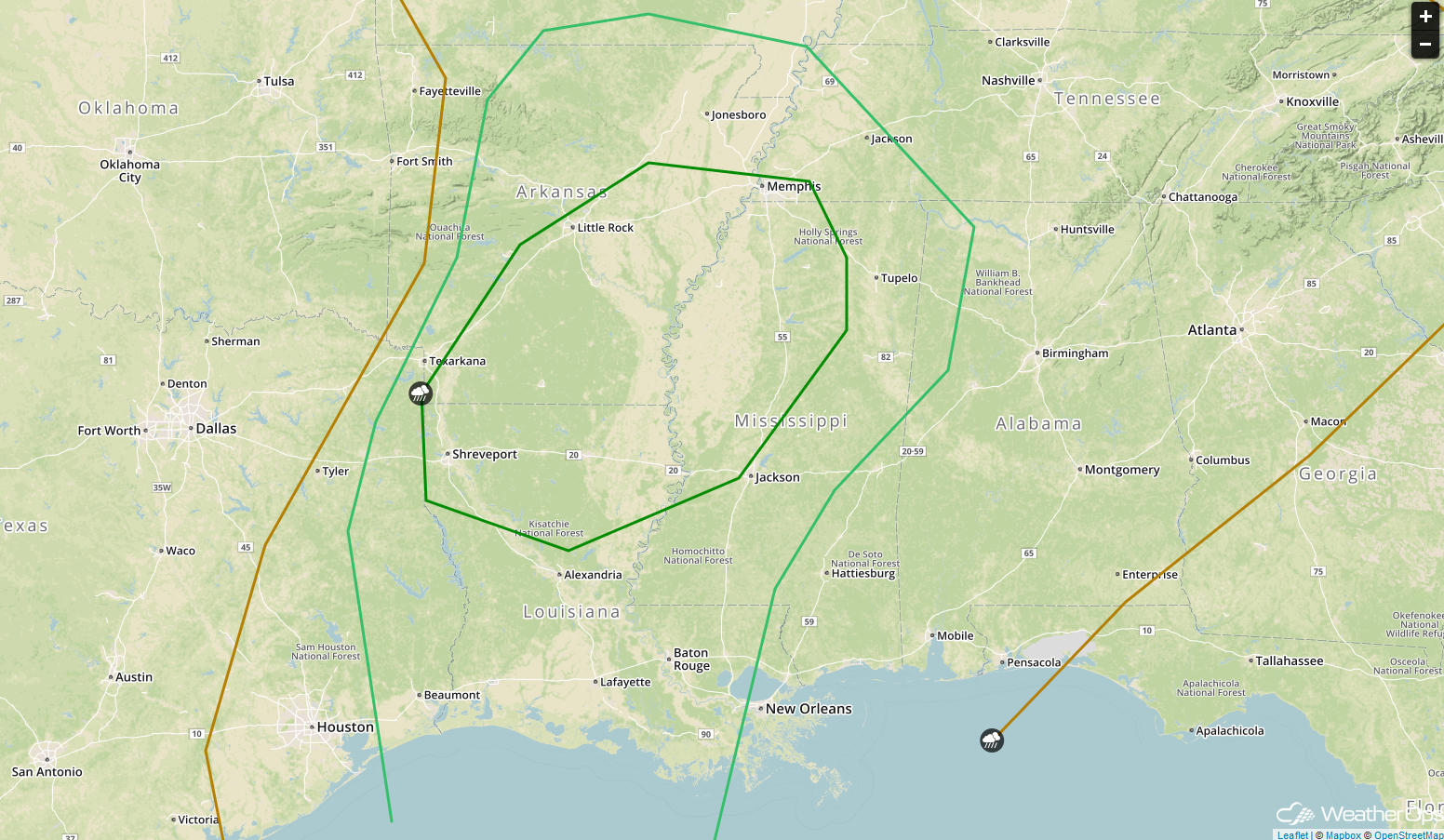 SPC Convective Outlook for Friday
A Look Ahead
An area of low pressure moving northward along the Northeast coast will bring the potential for snow to the region Monday into Tuesday. While details are unknown at this time, there appears to be the potential for several inches of snow.
That is a brief look at current weather hazards. We can provide you site-specific weather forecast information to protect your staff and assets and to assess your weather risk. Try a 7-day demo right away and learn how timely precision weather information can enhance your bottom line.
