


by David Moran, on Jun 6, 2018 11:10:03 AM
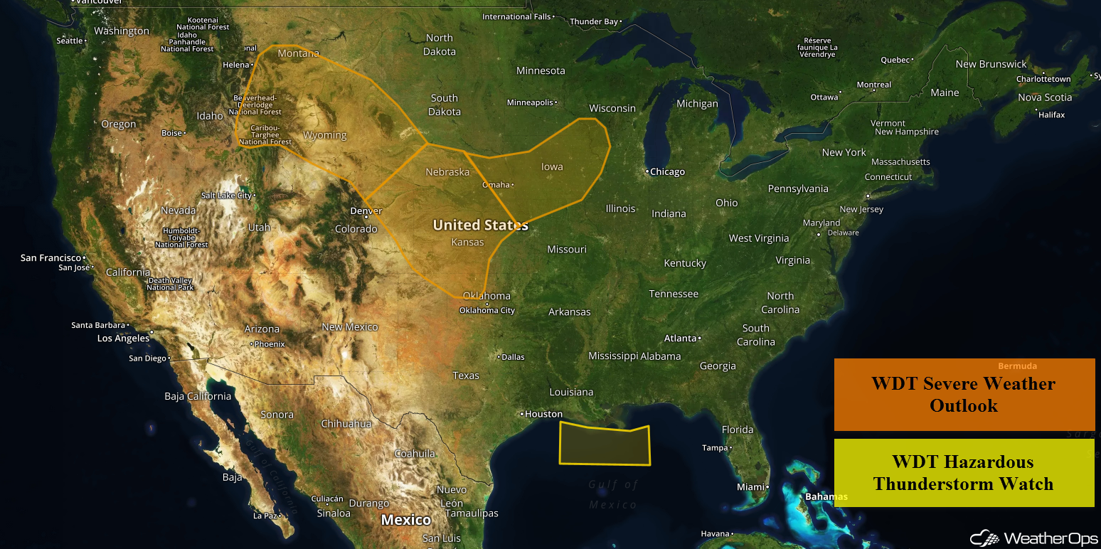
Thunderstorms will continue for portions of the Northern Gulf of Mexico throughout the day on Wednesday along a front off the Louisiana coast. A cold front will be the focus for the development of thunderstorms from the Central Plains into the Upper Mississippi Valley. Thunderstorms may develop across Montana and Wyoming eastward into Nebraska as a series of weak disturbances move across the region. As an area of low pressure intensifies in the lee of the Rockies, thunderstorms may develop across portions of Western Kansas and Northwestern Oklahoma.
- Continued Thunderstorms Wednesday across Portions of the Northern Gulf of Mexico
- Thunderstorm Potential from the Central Plains into the Upper Mississippi Valley on Wednesday
- Risk for Thunderstorms Wednesday across Montana and Wyoming into Nebraska
- Thunderstorms across Western Kansas and Northwest Oklahoma on Wednesday
- Potential for Thunderstorm for the Northern High Plains and Northern Plains on Thursday
- Thunderstorms Thursday for the Southern High Plains
- Risk for Thunderstorms from the Plains to the Mid Mississippi Valley Friday
 US Hazards

Continued Thunderstorms Wednesday across Portions of the Northern Gulf of Mexico
Thunderstorms will continue for portions of the Gulf of Mexico throughout the day on Wednesday along a cold front off the Louisiana coast. These storms will drift southward throughout the day with waterspouts, wind gusts in excess of 40 knots, heavy rain, and frequent lightning all potential hazards.
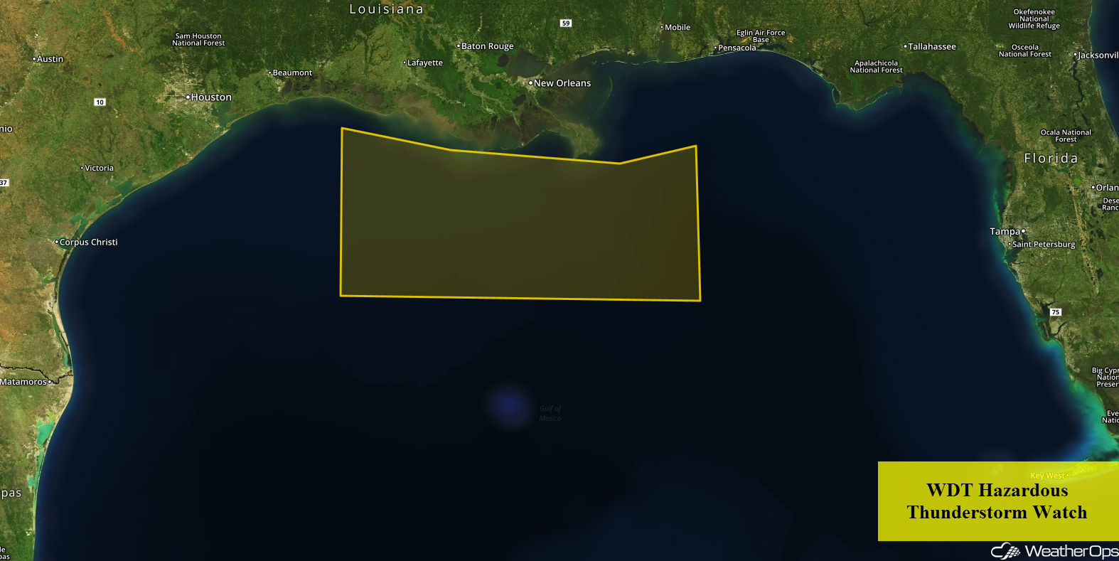 WDT Hazardous Thunderstorm Watch
Thunderstorm Potential from the Central Plains into the Upper Mississippi Valley on Wednesday
Thunderstorms are forecast from Nebraska eastward into Iowa and Minnesota ahead of a cold front on Wednesday. With plentiful moisture and strong daytime heating, instability should be sufficient for the development of thunderstorms along and ahead of the front. As storms develop, damaging winds and large hail will be the primary hazards. However, as storms evolve into clusters during the evening, the primary threat will become damaging winds.
Major Cities in Region: Goodland, KS, North Platte, NE, Omaha, NE, Des Moines, IA, Minneapolis, MN, Rochester, MN
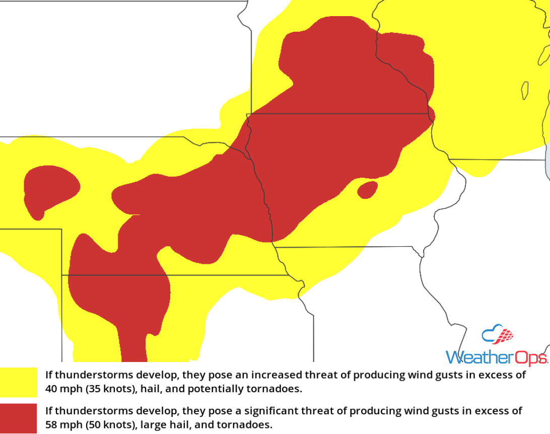 Thunderstorm Risk for Wednesday
Risk for Thunderstorms Wednesday across Montana and Wyoming into Nebraska
Southeasterly flow across portions of Wyoming and Montana will allow moisture to move northward into the region. Daytime heating will allow instability to build through the afternoon. In addition, a few weak disturbances will move over the region, allowing for the development of isolated strong to severe thunderstorms. Large hail and damaging winds will be the primary hazards with these storms.
Major Cities in Region: Billings, MT, Casper, WY, Scottsbluff, NE
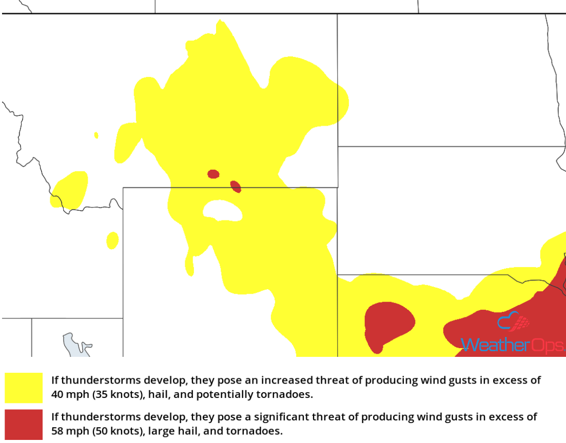 Thunderstorm Risk for Wednesday
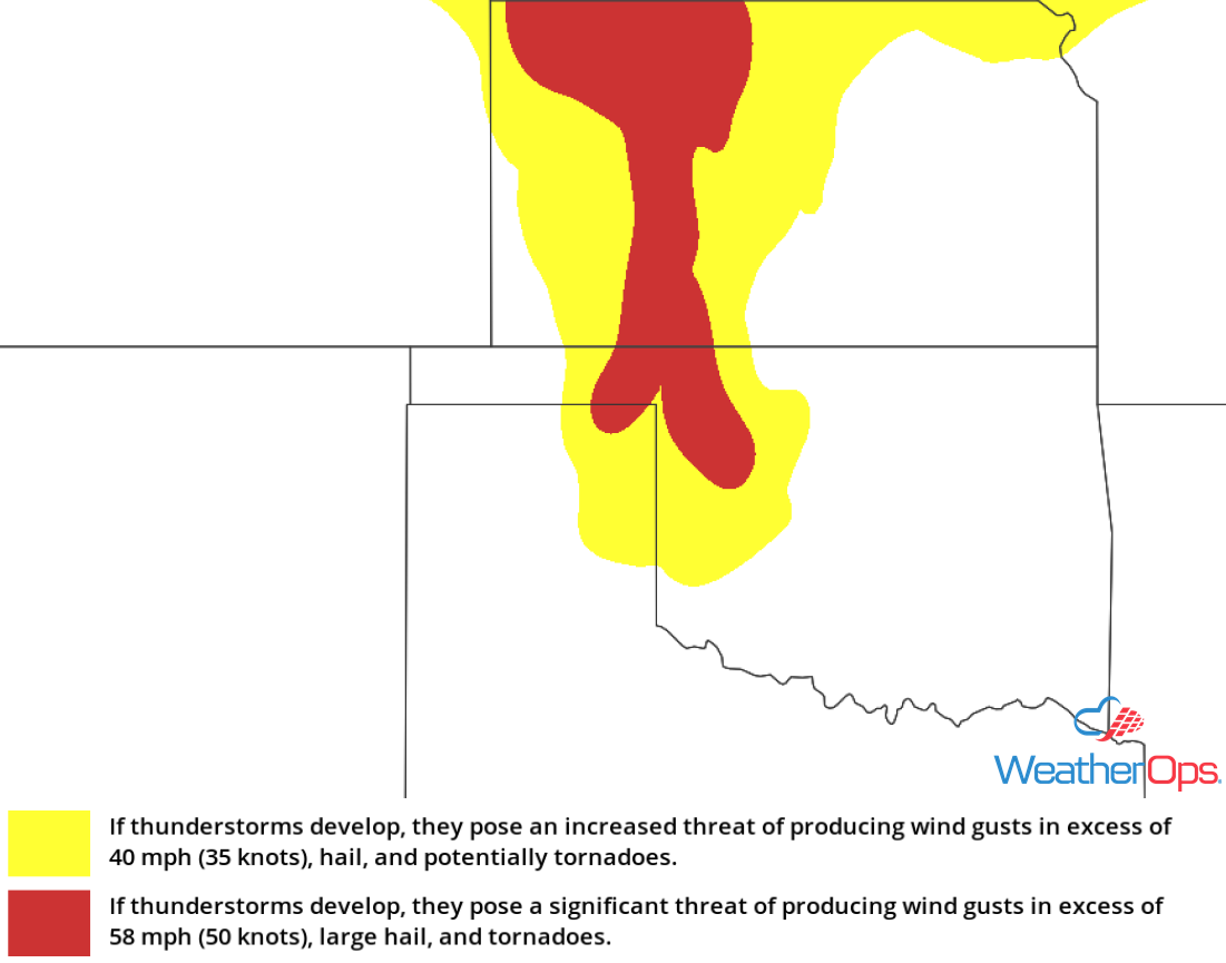
Thunderstorms across Western Kansas and Northwest Oklahoma on Wednesday
Southeasterly winds to the east of an area of low pressure in the lee of the Rockies will bring warm, moist air northward. This will allow for the development of a few strong to severe thunderstorms during the afternoon. Large hail will be the primary hazard with these storms, but there will also be a risk for damaging winds.
Major Cities in Region: Goodland, KS, Dodge City, KS, Woodward, OK
 Thunderstorm Risk for Wednesday
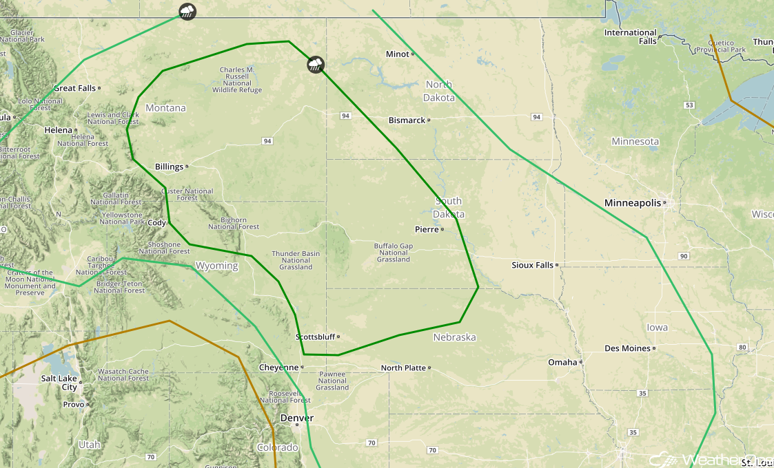
Potential for Thunderstorm for the Northern High Plains and Northern Plains on Thursday
As a ridge of high pressure builds into the Northern Plains and Upper Mississippi Valley on Thursday, southeasterly flow is expected from Nebraska into eastern Montana. This will bring moist air into the region; coupled with daytime heating, instability is expected to build. An upper level trough over the western US should allow weak disturbances to move across the region. This should allow for the development of strong to severe thunderstorms during the afternoon hours across Montana. The primary hazards with these storms will be damaging winds and large hail, but an isolated tornado or two cannot be ruled out. Storms that form clusters will move east-southeastward, bringing the potential for damaging winds to portions of western South Dakota and Nebraska overnight.
Major Cities in Region: Billings, MT, Scottsbluff, NE, Rapid City, SD, Pierre, SD
 SPC Convective Outlook for Thursday
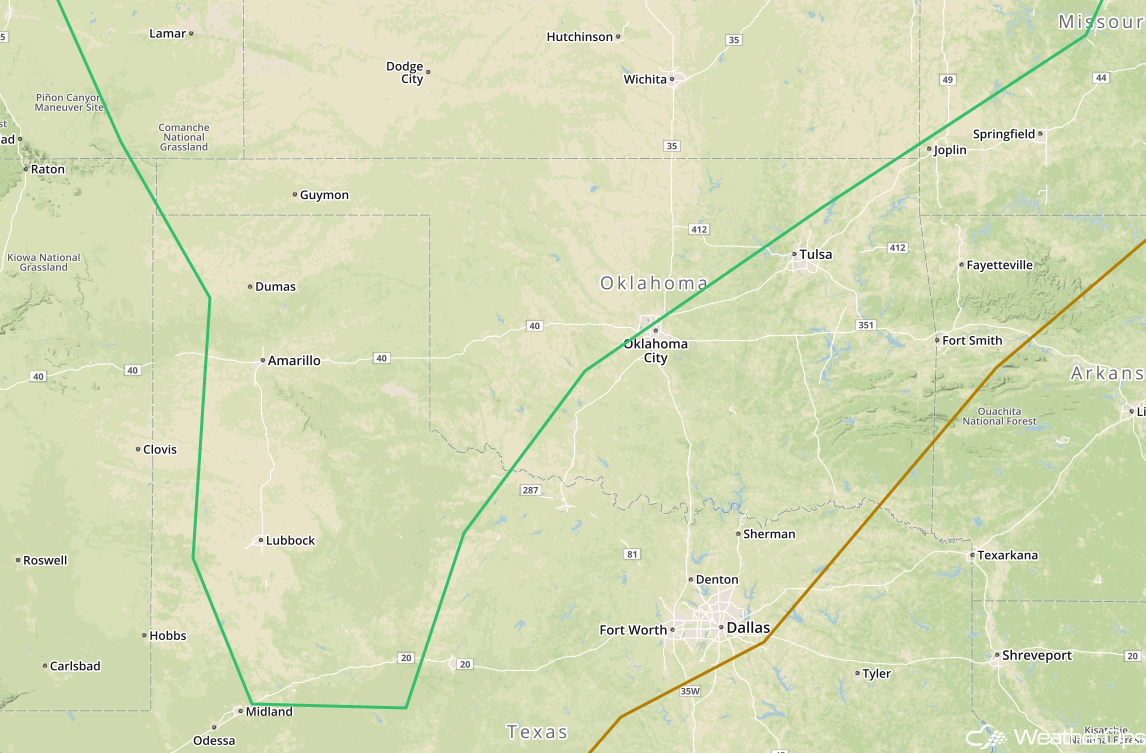
Thunderstorms Thursday for the Southern High Plains
A trough developing in the lee of the Rockies should bring moist air into the region on Thursday. This should cause enough destabilization to allow for the development of isolated strong to severe thunderstorms during the afternoon. Any storms that develop will be capable of producing damaging winds and large hail. Storms should diminish after sunset with the loss of daytime heating.
Major Cities in Region: Lubbock, TX, Amarillo, TX, Guymon, OK
 SPC Convective Outlook for Thursday
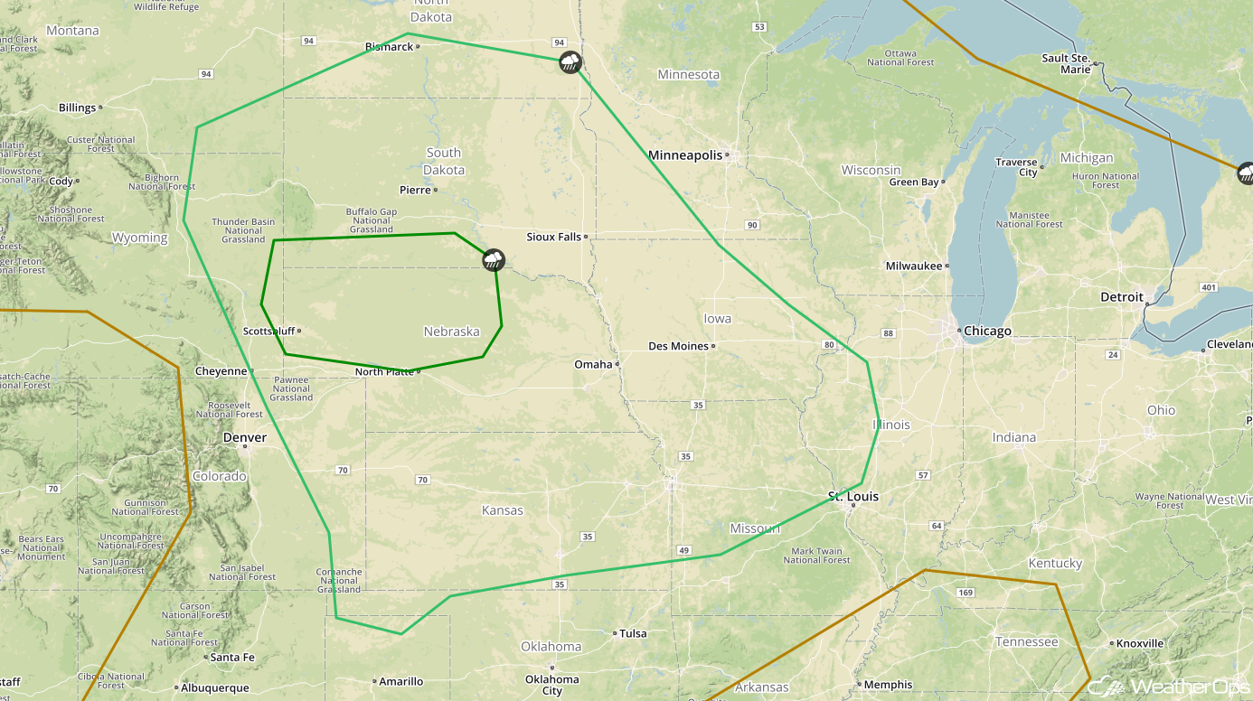
Risk for Thunderstorms from the Plains to the Mid Mississippi Valley Friday
Plentiful moisture will be in place across the Central Plains on Friday. With an area of low pressure developing in the lee of the Rockies, thunderstorms may develop across the High Plains during the afternoon. The primary hazards with any storms that develop will be large hail and damaging winds. Large clusters of storms may develop later in the day and move to the east or southeast during the evening and overnight hours. Damaging winds would be the primary concern with these storms.
Major Cities in Region: Dodge City, KS, Kansas City, MO, Scottsbluff, NE, Omaha, NE, Des Moines, IA, Sioux Falls, SD, Pierre, SD, Bismarck, ND
 SPC Convective Outlook for Friday
A Look Ahead
Showers and thunderstorms will continue across portions of the Plains Saturday morning as an area of low pressure continues to move eastward. Further east, showers and thunderstorms are forecast across the Great Lakes and into the Ohio Valley along a cold front. On Sunday, showers may linger across portions of Wisconsin and Illinois. Going into early next week, showers and thunderstorms may develop across portions of northern Florida on Monday ahead of a cold front. On Tuesday, thunderstorms may develop from the Great Lakes into the Plains as an area of low pressure moves across the Plains and Midwest.
This is just a brief look at current weather hazards. We can provide you site-specific weather forecast information for the purpose of protecting your personnel and assets and to assess your weather risk. Try a 7-day demo right away and learn how timely precision weather information can enhance your bottom line.
