


by David Moran, on Jun 20, 2018 12:28:44 PM
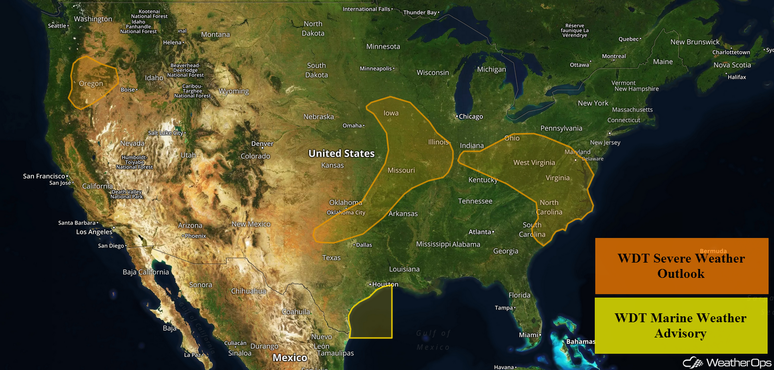
Heavy rainfall and flooding will continue across portions of Texas and Louisiana on Wednesday as an area of low pressure remains in place over the region. Elevated winds and seas are expected to continue for portions of the Gulf of Mexico through Thursday morning. Thunderstorms may develop across portions of the Plains and Midwest as an area of low pressure continues to move eastward. A stalled front will be the focus for the development of thunderstorms from the Ohio Valley into the Mid Atlantic. There will be a risk for excessive rainfall from the Plains into the Mid-Atlantic along this stalled front. Upslope flow may allow for the development of thunderstorms across the Pacific Northwest.
- Excessive Rainfall Continuing for Texas and Louisiana on Wednesday
- Elevated Winds and Seas Continuing through Thursday Morning for the Western Gulf of Mexico
- Thunderstorms for the Plains and Midwest on Wednesday
- Risk for Thunderstorms Wednesday from the Ohio Valley into the Mid Atlantic
- Potential for Excessive Rainfall from the Plains through the Mid Atlantic on Wednesday
- Thunderstorms Wednesday across the Pacific Northwest
- Thunderstorm Potential for the Middle and Lower Mississippi Valley on Thursday
- Risk for Thunderstorms Thursday across the Southern High Plains
- Thunderstorms for Central Montana on Thursday
- Excessive Rainfall Thursday from the Midwest into the Ohio Valley
- Potential for Thunderstorms across the Central Plains on Friday
- Thunderstorms Friday from the Lower Mississippi Valley into the Ohio Valley
 US Hazards

Excessive Rainfall Continuing for Texas and Louisiana on Wednesday
An area of low pressure will continue to promote prolonged periods of rainfall across eastern Texas and Louisiana today, with activity decreasing but continuing through Thursday. Rainfall totals of 1-3 inches with locally heavier amounts in excess of 4 inches are forecast. Due to previous days' rainfall, continued flooding concerns are likely and flash flooding is expected.
Major Cities in Region: Brownsville, TX, Corpus Christi, TX, Houston, TX, Shreveport, LA
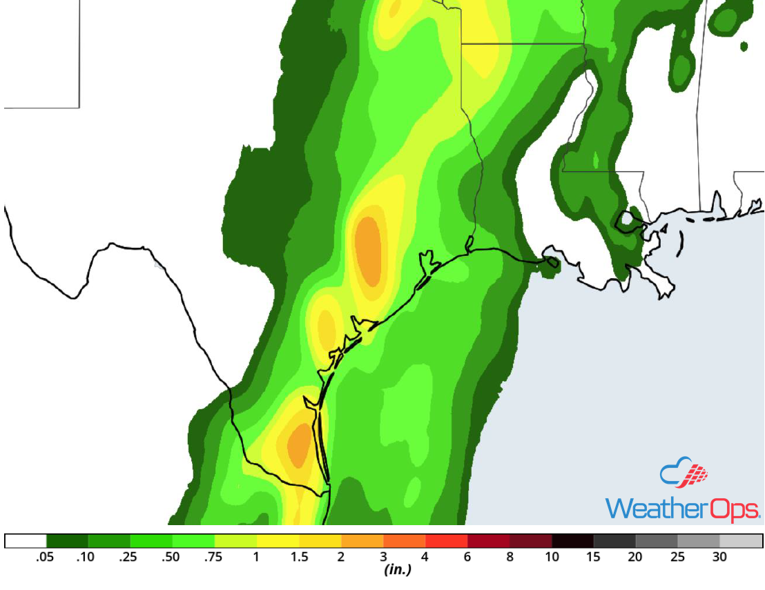 Rainfall Accumulation for Wednesday
Elevated Winds and Seas Continuing through Thursday Morning for the Western Gulf of Mexico
Elevated winds and seas will continue across portions of the western Gulf of Mexico through Thursday morning as a result of a weak tropical wave along the southeastern Texas coast. Sustained winds will range 20-30 knots with gusts in excess of 35 knots. In addition, seas will range 5-7 feet near the shore and 6-8 feet in the deeper waters. Shower and squall activity is also expected with winds gusting in excess of 50-60 knots.
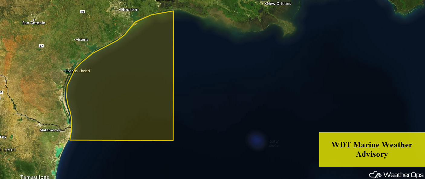 WDT Marine Weather Advisory
Thunderstorms for the Plains and Midwest on Wednesday
An upper level trough will be the main focus for the development of thunderstorms across the Plains and Midwest on Wednesday. Thunderstorms are ongoing across the Plains this morning, but activity will move into the Midwest by the afternoon. Outflow boundaries left behind by morning thunderstorms may allow for the redevelopment of thunderstorms across portions of the Plains during the afternoon. Damaging winds and large hail will be the primary hazards; a low tornado risk will exist across Iowa and northern Missouri where the strongest shear will be located.
Major Cities in Region: Lawton, OK, Oklahoma City, OK, Tulsa, OK, Kansas City, MO, Des Moines, IA
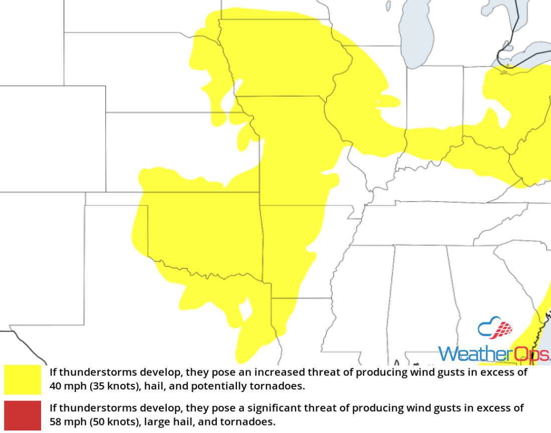 Thunderstorm Risk for Wednesday
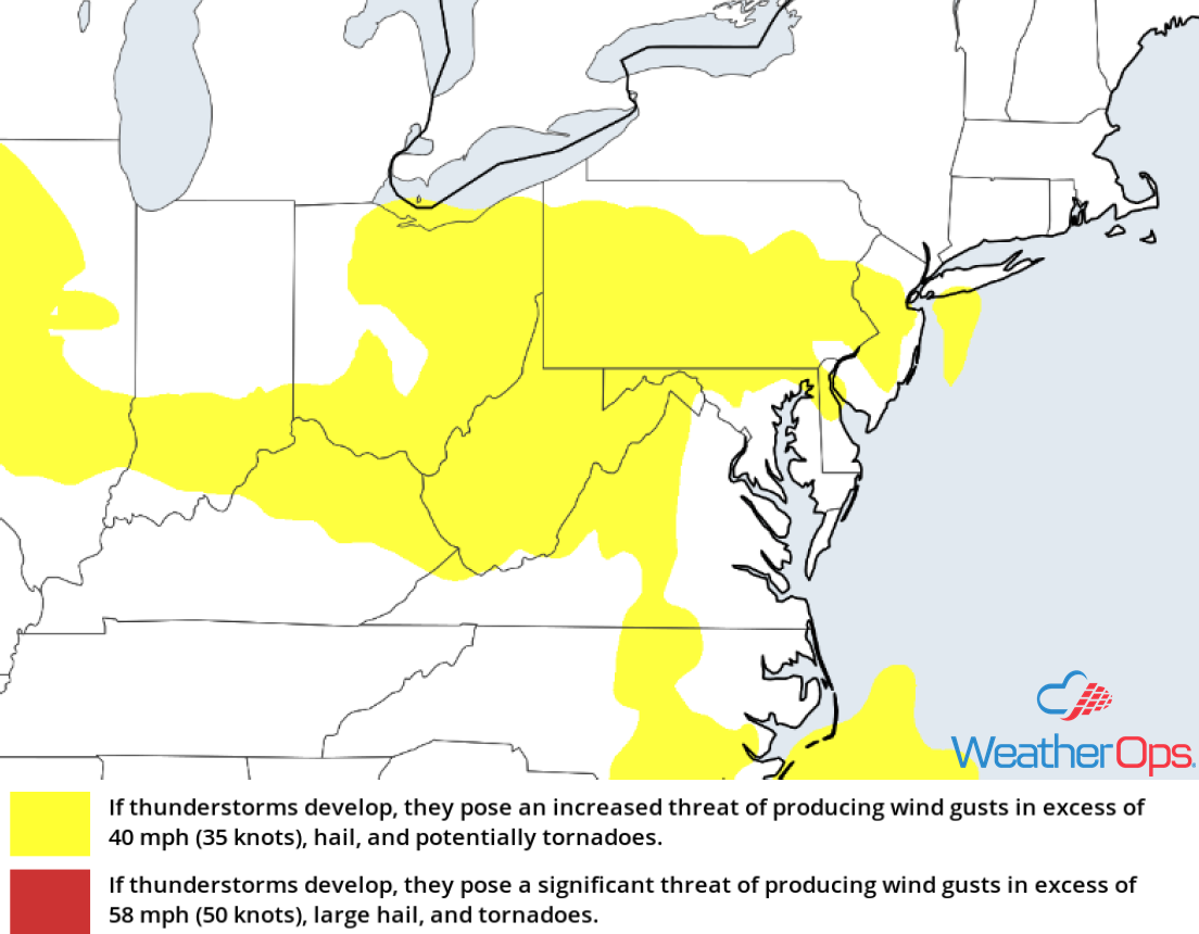
Risk for Thunderstorms Wednesday from the Ohio Valley into the Mid Atlantic
An area of low pressure and stalled front will promote isolated to widely scattered showers and thunderstorms during the afternoon as instability builds across the region. Strong to damaging winds and hail will be the primary hazards with these storms.
Major Cities in Region: Cincinnati, OH, Charleston, WV, Washington, DC
 Thunderstorm Risk for Wednesday
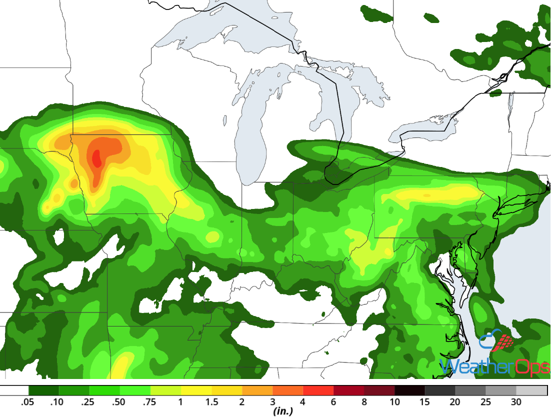
Potential for Excessive Rainfall from the Plains through the Mid Atlantic on Wednesday
With plentiful moisture along a stationary front extending from the Central Plains into the Mid Atlantic, widespread showers and thunderstorms are expected to develop. Widespread rainfall totals of 0.50-1.50 inch with locally higher amounts in excess of 3 inches forecast across the Central Plains and Midwest. Due to previous days rainfall, there will be an increased risk of flooding.
Major Cities in Region: Sioux City, IA, Des Moines, IA, Springfield, IL, Indianapolis, IN, Cincinnati, OH, Charleston, WV, Washington, DC, Baltimore, MD
 Rainfall Accumulation for Wednesday
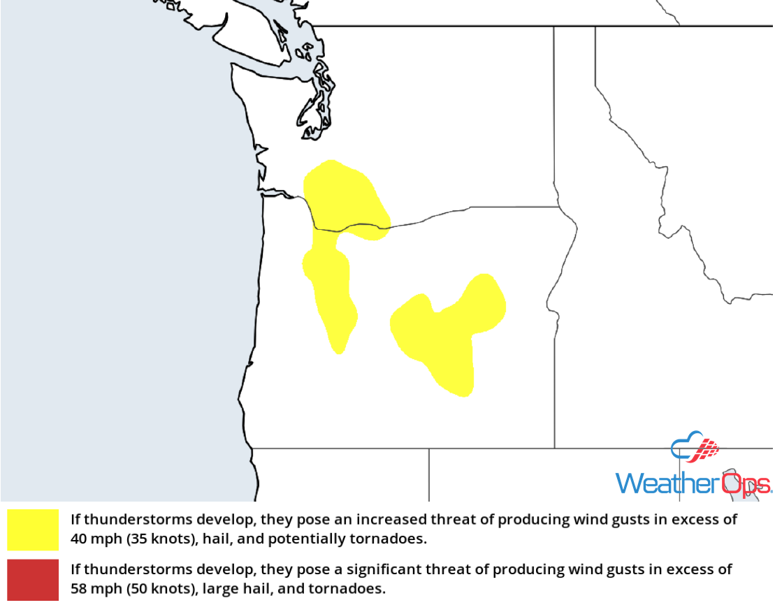
Thunderstorms Wednesday across the Pacific Northwest
Strong surface heating and cooler temperatures aloft will allow instability to build. A strong mid-level jet stream and westerly winds will promote upslope flow, allowing for the development of scattered thunderstorms by the afternoon. Strong winds and hail will be the primary hazards with these storms.
Major Cities in Region: Bend, OR
 Thunderstorm Risk for Wednesday
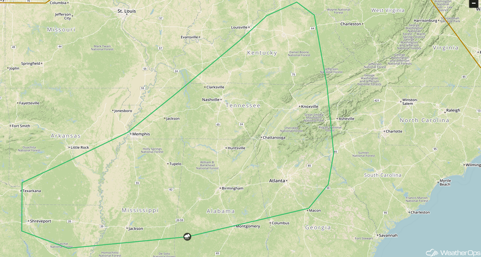
Thunderstorm Potential for the Middle and Lower Mississippi Valley on Thursday
Ongoing precipitation and cloud cover will be likely to start the day, with an area of low pressure developing over the Lower Mississippi Valley. A cold front is forecast to stretch southwestward into Texas with a warm front extending into the Ohio Valley. Plentiful moisture and daytime heating will allow instability to build, resulting in the development of thunderstorms. Damaging winds and hail will be the primary hazards with these storms.
Major Cities in Region: St. Louis, MO, Memphis, TN, Evansville, IN
 SPC Convective Outlook for Thursday
Risk for Thunderstorms Thursday across the Southern High Plains
Strong daytime heating, plentiful moisture, and southeasterly flow will create an environment favorable for the development of isolated thunderstorms across northeastern New Mexico by Thursday afternoon. Any thunderstorms that develop will move eastward into the Texas and Oklahoma Panhandles. Strong to damaging winds and large hail will be the primary hazards with these storms.
Major Cities in Region: Tucumcari, NM, Dalhart, TX
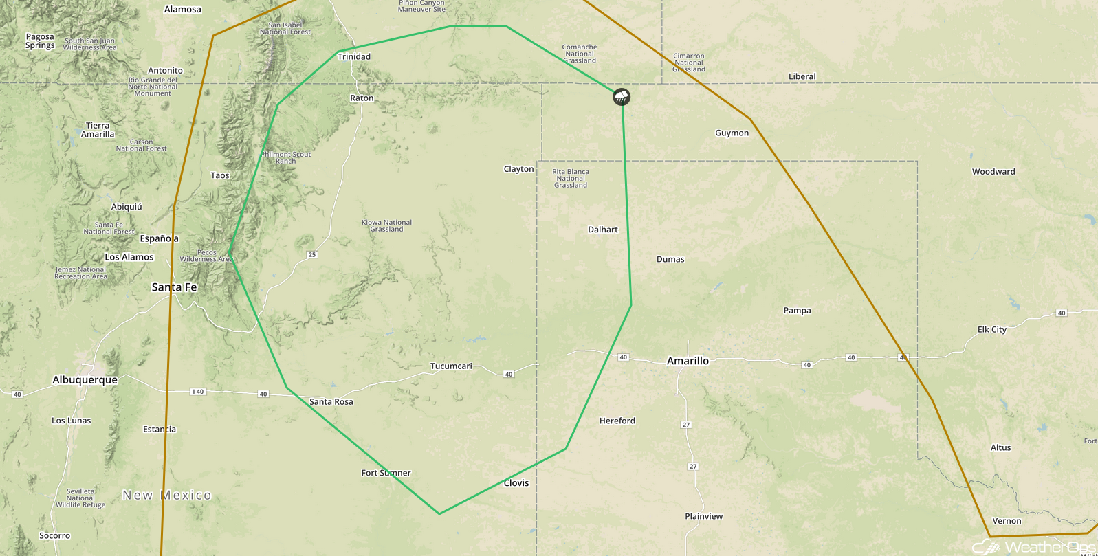 SPC Convective Outlook for Thursday
Thunderstorms for Central Montana on Thursday
An area of low pressure moving across the region will promote strong to severe thunderstorms along and ahead of an eastward moving cold front on Thursday. Cooling temperatures aloft will increase instability and with strong shear in place, strong winds and large hail will be the primary hazards with any storms that develop.
Major Cities in Region: Butte, MT, Helena, MT, Bozeman, MT, Billings, MT
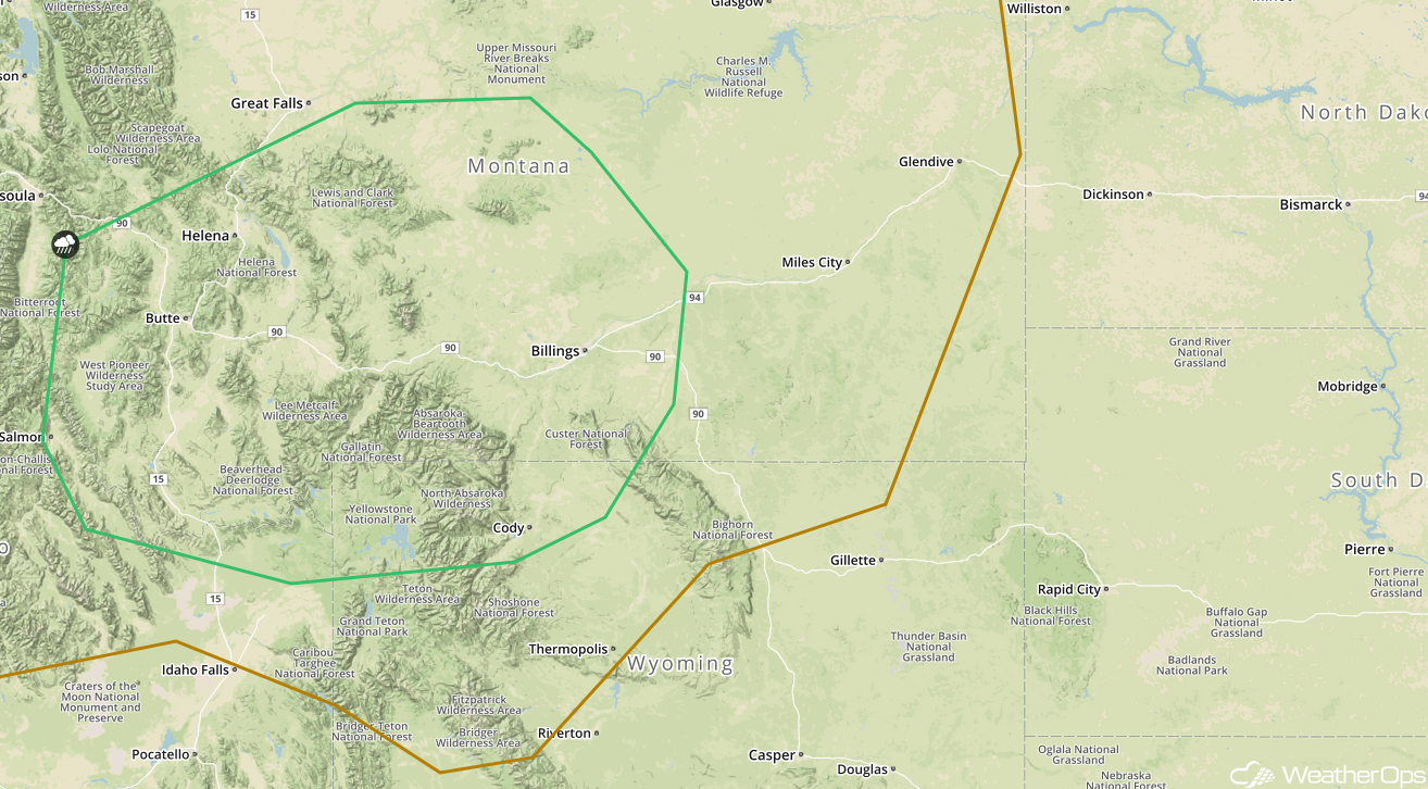 SPC Convective Outlook for Thursday
Excessive Rainfall Thursday from the Midwest into the Ohio Valley
An area of low pressure lifting northeastward through the central US will bring heavy to excessive rainfall to portions of the Midwest and Ohio Valley on Thursday. Rainfall totals will range 0.50-1.50 inches with locally heavier amounts in excess of 2 inches. Due to moist soil from previous days' rainfall, there will be a risk for flooding and flash flooding.
Major Cities in Region: Dubuque, IA, Peoria, IL, Indianapolis, IN, Columbus, OH
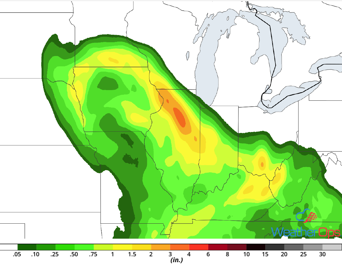 Rainfall Accumulation for Thursday
Potential for Thunderstorms across the Central Plains on Friday
A shortwave trough is forecast to move across the Rockies and into the Central Plains on Friday, with an area of low pressure forecast to develop near the Texas Panhandle by Friday evening. Plentiful moisture and daytime heating will lead to the development of isolated thunderstorms across the region by the late afternoon. Strong winds, large hail, a few tornadoes will all be potential hazards.
Major Cities in Region: Amarillo, TX, Dodge City, KS, Oklahoma City, OK
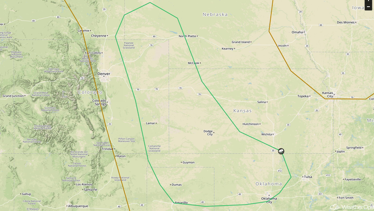 SPC Convective Outlook for Friday
Thunderstorms Friday from the Lower Mississippi Valley into the Ohio Valley
An area of low pressure is expected to move across the region on Friday. Abundant moisture and strong daytime heating will allow instability to build across the region, leading to the development of thunderstorms. Strong to damaging winds and hail will be the primary hazards with these storms.
Major Cities in Region: Memphis, TN, Jackson, MS, Nashville, TN. Louisville, KY
 SPC Convective Outlook for Friday
A Look Ahead
Showers and thunderstorms will continue across portions of the Southern Plains and Lower Mississippi Valley into Saturday morning as an area of low pressure moves eastward. Later in the day, thunderstorms may develop across the Northern Plains. On Sunday, thunderstorms may develop across the Central High Plains as an area of low pressure intensifies. Going into Monday, thunderstorms may develop across portions of the Central Plains. Showers and thunderstorms may extend from the Upper Midwest into the Southern Plains ahead of a cold front on Tuesday.
This is just a brief look at current weather hazards. We can provide you site-specific weather forecast information for the purpose of protecting your personnel and assets and to assess your weather risk. Try a 7-day demo right away and learn how timely precision weather information can enhance your bottom line.
