National Weather Summary for Wednesday, July 26, 2017
by David Moran, on Jul 26, 2017 10:53:08 AM
Thunderstorms are forecast from the Midwest into the Great Lakes on Wednesday as a cold front continues to progress eastward. Monsoonal moisture coupled with an upper level trough will produce some thunderstorms across Nevada Wednesday. Heavy rainfall is expected across Colorado and New Mexico as an area of low pressure moves northeast of the region.
- Thunderstorm Potential from the Midwest into the Great Lakes on Wednesday
- Risk for Thunderstorms Wednesday across Nevada
- Excessive Rainfall for Colorado and New Mexico on Wednesday
- Strong to Severe Thunderstorms Thursday from the Mississippi Valley through the Mid Atlantic
- Potential for Thunderstorms from the Northern Rockies through the High Plains on Thursday
- Excessive Rainfall Thursday for the Four Corners
- Thunderstorms from the Southern US through the Mid Atlantic on Friday
- Risk for Excessive Rainfall Friday across the Mid Atlantic
- Potential for Thunderstorms for the Central and Northern High Plains on Friday
- Excessive Rainfall Continues for the Four Corners on Friday
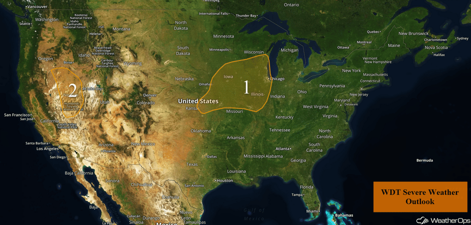 US Hazards
Thunderstorm Potential from the Midwest into the Great Lakes on Wednesday
A complex of showers and thunderstorms from southern Minnesota into eastern Kansas is weakening. Generally non-severe thunderstorms are likely through midday as instability increases as the complex moves into central Iowa. By mid afternoon, thunderstorms may reintensify as instability increases ahead of the current storms. Isolated severe storms may develop across western and central portions of the region through mid to late afternoon. The greatest concentration of strong to severe thunderstorms isn't expected to reach southern Wisconsin and Illinois until after 4pm. Damaging winds will be the primary hazard with these storms, but there is a lesser risk for hail and an isolated tornado. The most likely region for severe thunderstorms will be from roughly Kansas City northeastward into Rockford, Illinois.
Major Cities in Region: Kansas City, MO, Des Moines, IA, St. Louis, MO, Milwaukee, WI, Chicago, IL
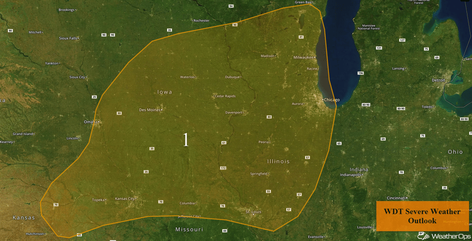 Region 1
Risk for Thunderstorms Wednesday across Nevada
Marginal instability and an upper level disturbance should allow for the development of a few isolated strong thunderstorms within the higher terrain by the mid to late afternoon. Damaging winds should be the primary hazard with any storms that develop. Activity should decrease after sunset.
Major Cities in Region: Elko, NV
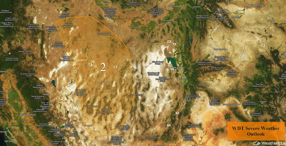 Region 2
Excessive Rainfall for Colorado and New Mexico on Wednesday
An area of low pressure moving to the northeast of the region and monsoonal moisture lifting northward will cause moderate to heavy rainfall for Colorado and northern New Mexico. Rainfall totals of 1-1.5 inches with locally higher amounts in excess of 2 inches are expected.
Major Cities in Region: Colorado Springs, CO, Trinidad, CO
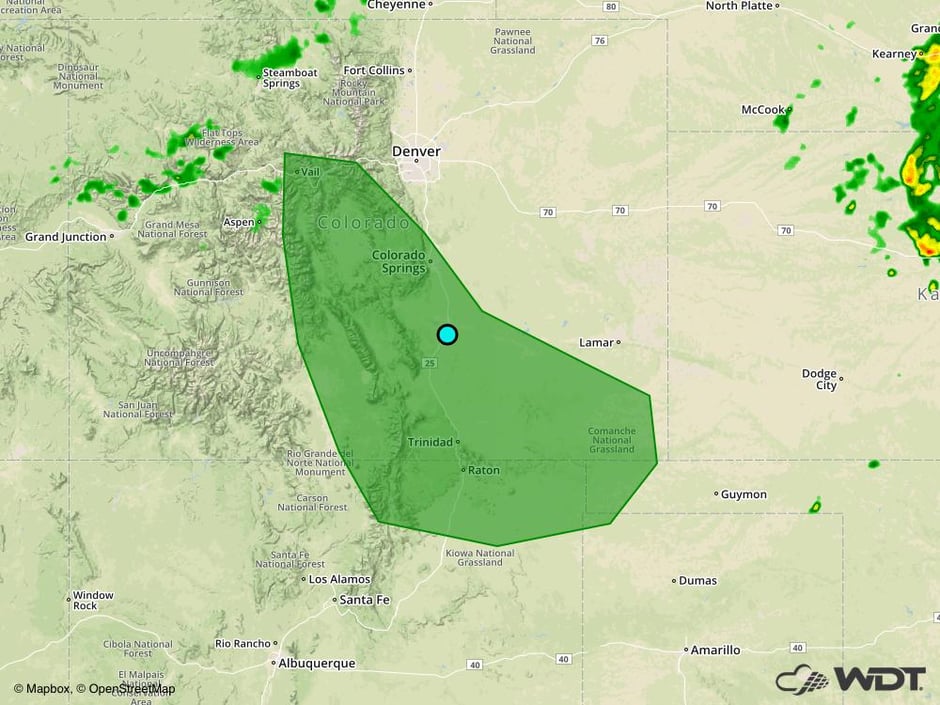 Excessive Rainfall Risk for Wednesday
Strong to Severe Thunderstorms Thursday from the Mississippi Valley through the Mid Atlantic
Ongoing showers and thunderstorms across the region from Wednesday will likely limit much of the severe weather threat on Thursday. Regardless, destabilization is forecast to be sufficient for the development of thunderstorms capable of producing damaging winds, with lines of storms developing. These storms will likely continue into the evening and overnight hours. A few isolated storms may also develop, which would have a risk for hail and damaging winds. Excessive rainfall will also be a threat with rainfall amounts around an inch and locally higher amounts in excessive of 1.5 inches.
Major Cities in Region: Nashville, TN, Louisville, KY, Knoxville, TN, Richmond, VA, Washington, DC, Philadelphia, PA, New York, NY
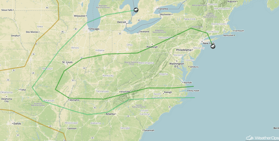 SPC Convective Outlook for Thursday
Potential for Thunderstorms from the Northern Rockies through the High Plains on Thursday
Thunderstorms may develop across the Northern Rockies into the High Plains on Thursday as an upper level trough moves over the region. Most storms should remain below severe limits, but damaging winds will be a potential hazard through the evening hours. Storms should dissipate after sunset.
Major Cities in Region: Helena, MT, Billings, MT, Cheyenne, WY, Denver, CO
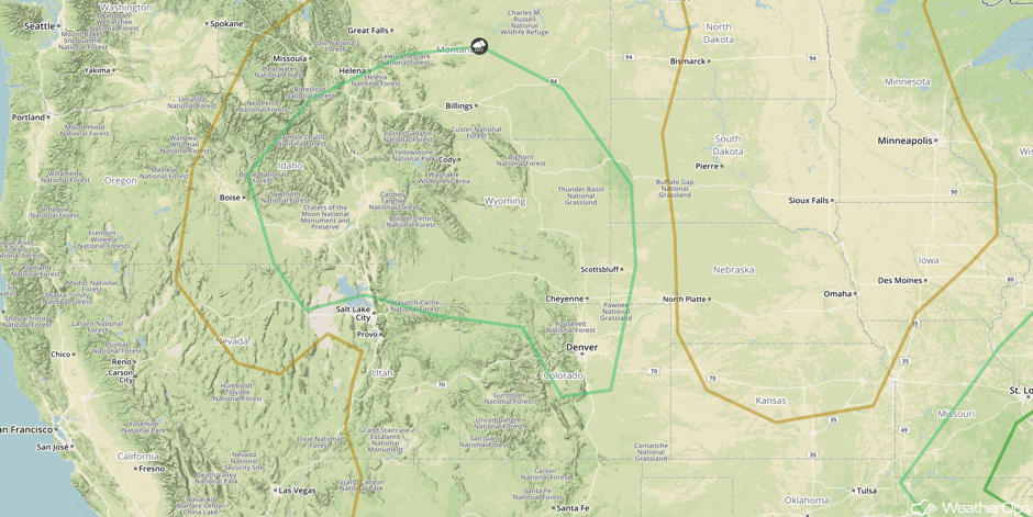 SPC Convective Outlook for Thursday
Excessive Rainfall Thursday for the Four Corners
Monsoonal moisture and a cold front moving southward into the region will produce plentiful shower and thunderstorm activity. Widespread amounts of an inch with locally higher amounts in excess of 1.5 inches are expected.
Major Cities in Region: Albuquerque, NM
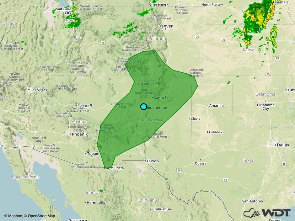 Excessive Rainfall Risk Outline for Thursday
Thunderstorms from the Southern US through the Mid Atlantic on Friday
The severe threat for Friday remains largely uncertain due to widespread activity leftover from Thursday. Some of the morning activity will likely be strong enough to produce severe wind gusts. Later in the afternoon, new thunderstorm activity may develop ahead of the cold front, as well as along any outflow boundaries. These storms will likely become linear with damaging winds being the primary hazard. A risk for hail and an isolated tornado cannot be ruled out.
Major Cities in Region: Little Rock, AR, Memphis, TN, Jackson, MS, Atlanta, GA, Knoxville, TN, Raleigh, NC, Washington, DC, Norfolk, VA
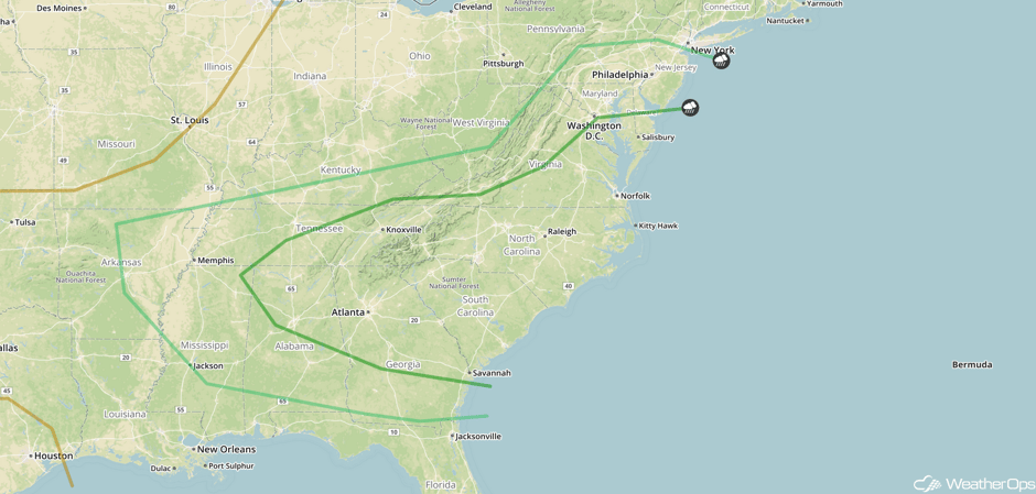 SPC Convective Outlook for Friday
Risk for Excessive Rainfall Friday across the Mid Atlantic
A strong area of low pressure and cold front will produce multiple bouts of rainfall across the Mid Atlantic on Friday with a risk of flooding. Rainfall totals of 1-2 inches are forecast with locally heavier amounts in excess of 3 inches.
Major Cities in Region: Pittsburgh, PA, Washington, DC, Baltimore, MD, Philadelphia, PA, New York, NY
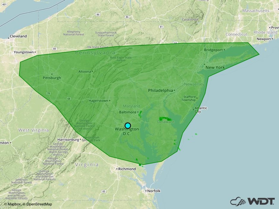 Excessive Rainfall Risk Outline for Friday
Potential for Thunderstorms for the Central and Northern High Plains on Friday
A weak area of low pressure moving through the region will promote the development of thunderstorm activity on Friday for the High Plains. Storms may cluster or perhaps congeal into a line. Damaging winds will be the primary hazard, but some hail cannot be ruled out. Storms will weaken quickly after sunset.
Major Cities in Region: Denver, CO, Cheyenne, WY, North Platte, NE
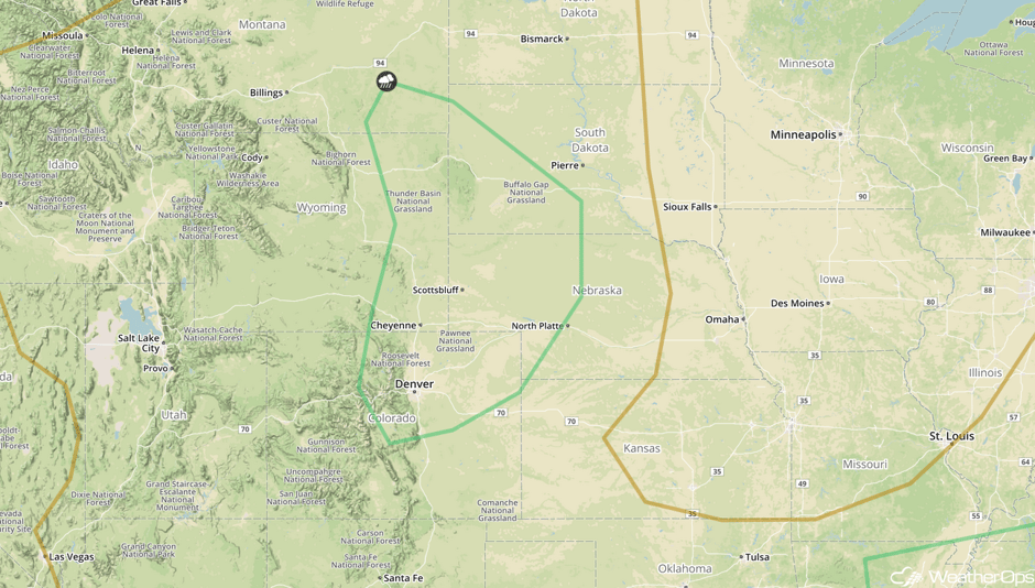 SPC Convective Outlook for Friday
Excessive Rainfall Continues for the Four Corners on Friday
Localized heavy rainfall may develop on Friday for portions of the Four Corners region and into the Colorado and New Mexico Rockies. Rainfall totals will average near an inch with flooding likely due to already saturated grounds.
Major Cities in Region: Los Alamos, NM, Colorado Springs, CO
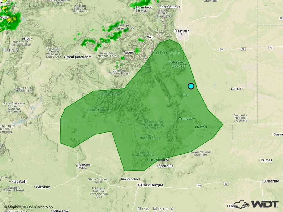 Excessive Rainfall Risk Outline for Friday
A Look Ahead
Thunderstorms may develop across the Southeast and Gulf Coast on Saturday ahead of a cold front. Large hail and damaging winds will be the primary hazards. In addition, rainfall amounts of 1-2 inches are forecast.
This is just a brief look at current weather hazards. We can provide you site-specific weather forecast information for the purpose of protecting your personnel and assets and to assess your weather risk. Try a 7-day demo right away and learn how timely precision weather information can enhance your bottom line.


