


by David Moran, on Feb 8, 2017 11:21:32 AM
Strong to severe thunderstorms may develop Wednesday across the Tennessee Valley into the Carolinas and southern Virginia ahead of a cold front. Snow will continue through the day on Wednesday across the Plains and Midwest. A wintry mix is forecast for portions of Washington as a strong Pacific low moves into the region. The system currently bringing snow to portions of the Plains and Midwest will move eastward, bringing snow to portions of the Mid Atlantic and Northeast late Wednesday into Thursday morning. Marine fog is likely for portions of the Gulf coast through the day on Wednesday.
 US Hazards

Region 1
There will be a chance for strong to severe thunderstorms from the Tennessee Valley into the Carolinas and southern Virginia tonight. An area of low pressure will track north of the region later today, with showers and thunderstorms developing ahead of the associated cold front by the early evening. Environmental conditions will support some storms becoming severe as the activity shifts eastward through the evening. Primary hazards with any storm that becomes severe will be large hail and damaging winds.
Major Cities in Region: Atlanta, GA, Chattanooga, TN, Knoxville, TN, Asheville, NC, Raleigh, NC, Myrtle Beach, SC, Norfolk, VA
 Region 1
Region 2
A fast moving upper level system will continue to bring snow to portions of the Plains and Midwest through Wednesday evening. Snowfall totals of 2-4 inches are expected.
Update 12:30pm CST: Heavy snow across portions of Illinois, Indiana, and Ohio.Close call - pickup truck spins out in front of 18 wheeler on snow-covered I-55 in Lincoln, IL this morning. https://t.co/PhjfzdMlw2 #ilwx pic.twitter.com/8Y9K3sUfhm
— Dan Robinson (@stormhighway) February 8, 2017

LIVE CAM - Champaign, IL
— Weather Webcam (@ActiveWxCams) February 8, 2017
29° with moderate snow. 1-2" on the ground so far #ilwx https://t.co/IPzWZuS2DI pic.twitter.com/zXkpwSaTU0
Major Cities in Region: Rapid City, SD, Omaha, NE, Sioux City, IA, Des Moines, IA, Davenport, IA, Peoria, IL
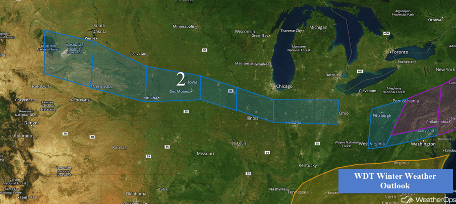 Region 2
Region 3
Snow will continue across Region 3 as an area of low pressure moves into the region. Ample moisture combined with a warm front moving through the region will lead to an increase in coverage and intensity of snowfall during the morning hours on Wednesday. With warm air moving into the region, snowfall will primarily be confined to the higher elevations with valleys receiving rain. Snowfall is expected to end across the higher elevations Wednesday evening as warm air continues to filter into the region.
Major Cities in Region: Yakima, WA
 Region 3
Region 4
A fast moving area of low pressure is forecast to track to the northeast across Virginia on Wednesday and Thursday, bringing snowfall to areas north and northwest of the center of the low. Westernmost portions of Region 4 are forecast to receive 2-4 inches of snow with 4-8 inches expected from central Pennsylvania through eastern New York. From Connecticut northeastward into Maine, 8-12 inches of snow are expected with isolated higher amounts in excess of 15 inches.
Major Cities in Region: Pittsburgh, PA, Baltimore, MD, Philadelphia, PA, New York, NY, Boston, MA, Portland, ME, Bangor, ME
 Region 4
Region 5
Fog is likely over the western Gulf of Mexico through Wednesday night. The fog may thin and breakup somewhat during the afternoon Wednesday before becoming dense again Wednesday evening. A cold front moving offshore late Wednesday night should end the fog threat from north to south through Thursday morning.
 Region 5
Excessive Rainfall Possible for Pacific Northwest Wednesday and Thursday
A potent area of low pressure will track toward the Pacific Northwest over the next few days. As this happens, its associated warm front will lift northwards across California and into Washington. This will bring plentiful moisture to the Pacific Northwest. With the warm front providing ample lift for this deep moisture, rain will begin to increase in coverage and intensity across the outlook area today. This heavy rain will continue across the region through Thursday before a cold front moves through Thursday evening. Rainfall totals over the next two days will generally be around 6-10 inches with some areas receiving in excess of 13 inches where there are terrain impacts and precipitation banding occur.
Major Cities in Region: Seattle, WA, Portland, OR, San Francisco, CA, Sacramento, CA
 Excessive Rainfall Outline for Wednesday and Thursday
A Look Ahead
Light snow is likely across the Intermountain West on Friday as an upper level disturbance makes its way eastward; snowfall accumulations of 1-2 inches are expected with isolated higher amounts in excess of 3 inches. Quiet weather is expected across most of the country over the weekend. A weak area of low pressure may bring some light snow to portions of the Great Lakes on Saturday. Later in the day, thunderstorms may develop across the Tennessee and Ohio Valleys ahead of the cold front associated with the area of low pressure over the Great Lakes. As this area of low pressure will continue to move northeastward on Sunday, light wintry precipitation is expected across the Northeast. Showers and thunderstorms may develop across portions of the Mid Atlantic.
This is just a brief look at current weather hazards. We can provide you site-specific forecast information for the purpose of protecting your personnel and assets. Try a 7-day demo right away and learn how timely precision weather information can enhance your bottom line.
