


by David Moran, on Feb 27, 2019 10:47:44 AM
Snow will continue from the Great Lakes into the Northeast on Wednesday as an area of low pressure moves eastward. A stalled front will allow for continued snow from the western US into the Northern Rockies through Thursday. Freezing rain will continue through Thursday from the Central Plains into the Ozarks. Fog will persist along the Texas and Louisiana coasts through Saturday morning.
- Snow from the Great Lakes into the Northeast on Wednesday
- Continued Snow through Thursday from the Western US into the Northern Rockies
- Freezing Rain from the Central Plains through the Ozarks through Thursday
- Fog through Saturday Morning along the Texas and Louisiana Coasts
- Thunderstorms for the Central and Eastern Gulf Coast Thursday and Friday
- Snow Friday for the Northern Plains and Upper Midwest
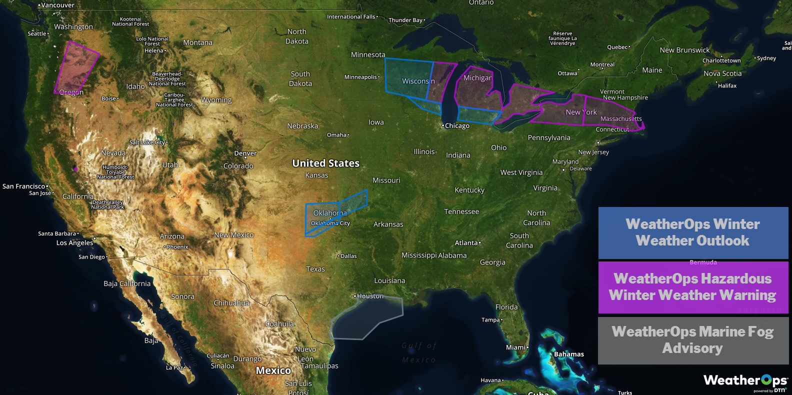
US Hazards
Snow from the Great Lakes into the Northeast on Wednesday
Moderate snowfall associated with an area of low pressure progressing eastward is ongoing from northern and central Michigan eastward into northern Ohio and into New York. The heaviest snow will be across western New York where 6-8 inches are forecast. Elsewhere, 3-6 inches are generally expected.
Major Cities in Region: Green Bay, WI, Milwaukee, WI, Grand Rapids. MI, Bay City, MI, Buffalo, NY, Syracuse, NY, Albany, NY

Snow Accumulation for Wednesday
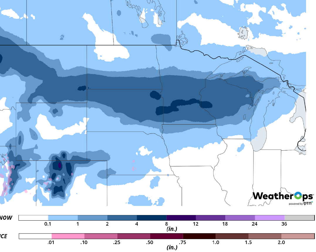
Continued Snow through Thursday from the Western US into the Northern Rockies
A stalled front will result in additional moderate to heavy snowfall across the region through Thursday. Snow accumulations of 4-8 inches with locally higher amounts in excess of 10 inches are expected in the lower elevations. In the higher elevations, 8-12 inches with locally higher amounts in excess of 15 inches are forecast.
Major Cities in Region: Bend, OR, Yakima, WA, Missoula, MT
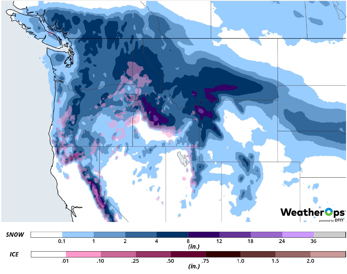
Snow Accumulation through Thursday
Freezing Rain from the Central Plains through the Ozarks through Thursday
Sub-freezing temperatures and light accumulations of freezing rain have already resulted in extremely slick roadways and hazardous travel conditions across central and north central Oklahoma. Similar impacts can be expected from eastern Oklahoma into southern Missouri through Thursday. Ice accumulations will range from a glaze to 0.20 inch.
Major Cities in Region: Lawton, OK, Oklahoma City, OK, Tulsa, OK, Fayetteville, AR, Springfield, MO
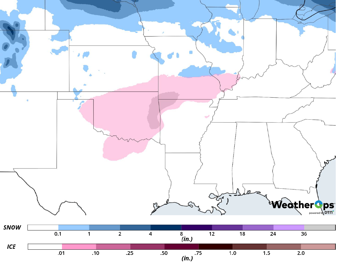
Snow and Ice Accumulation through Thursday
Fog through Saturday Morning along the Texas and Louisiana Coasts
Light winds and abundant moisture will allow for the development of fog along the Texas and Louisiana coasts through Saturday morning. Visibilities will be less than a mile at times.
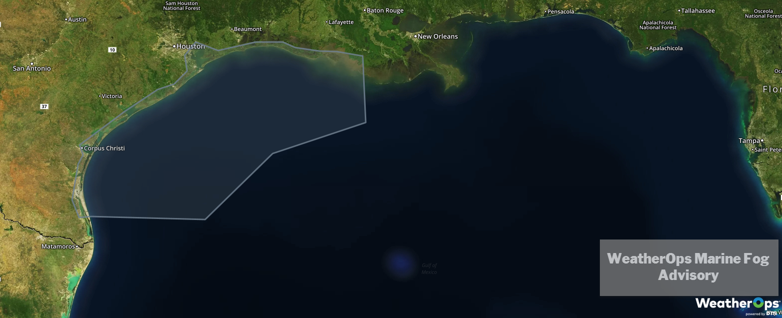
WeatherOps Marine Fog Advisory
Thunderstorms for the Central and Eastern Gulf Coast Thursday and Friday
A slow moving cold front will progress eastward across the Southeast Thursday and Friday. Marginal instability along the front, combined with mid-level disturbances moving across the region, will allow for the development of scattered thunderstorms. Damaging winds, hail, and brief tornadoes will be potential hazards with these storms.
Major Cities in Region: Baton Rouge, LA, New Orleans, LA, Mobile, AL, Pensacola, FL, Montgomery, AL, Tallahassee, FL
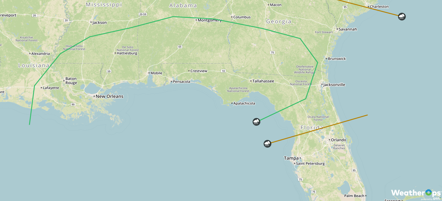
SPC Convective Outlook for Thursday
Snow Friday for the Northern Plains and Upper Midwest
A strong surge of Arctic air combined with a weak disturbance will allow for the development of light to moderate snow across the region on Friday. Snow accumulations of 2-4 inches are expected from the central Dakotas into Minnesota and Wisconsin.
Major Cities in Region: Pierre, SD, Grand Forks, ND, Sioux Falls, SD, Minneapolis, MN, Wausau, WI, Green Bay, WI
Snow Accumulation for Friday
A Look Ahead
Light snow is expected across the Ohio Valley on Saturday as a cold front moves across the region. By Sunday, snow will extend from the Appalachians into the Ohio Valley. Snow is forecast across portions of the Rockies on Monday. A weak disturbance may produce some light snow Tuesday across the Plains,
