


by David Moran, on Dec 21, 2016 11:23:25 AM
No WeatherOps hazards are currently in effect. A strong area of low pressure moving through the Northern Plains will allow for the development of snow across the Great Lakes on Wednesday. Across the Cascades, snow is expected as an area of low pressure and cold front moves into the Western US. Light snow is likely across the Colorado Rockies as a weak system moves across the southern Rockies. As the cold front across the Western US continues to move eastward, there will be the potential for heavy snow across the Sierra Nevada. This same system may bring excessive rainfall to portions of California.
 US Hazards

Significant Snowfall Possible for the Great Lakes on Wednesday
An area of low pressure will move across the Northern US on Wednesday, allowing for snowfall for the Great Lakes throughout the day. Overall snow amounts are expected to be around 3-5 inches with locally heavier amounts in excess of 6 inches within the heaviest bands.
Update 12:40pm CST: Snow continuing across northeastern Minnesota and northern Wisconsin.
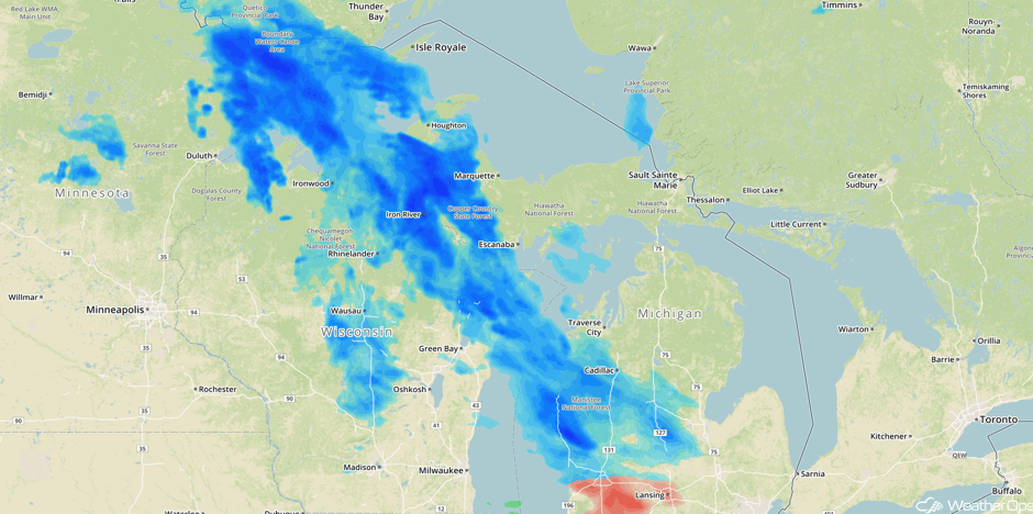 Radar 12:40pm CST
Major Cities in Region: Fargo, ND, Duluth, MN, Green Bay, WI
 Significant Snowfall Risk Outline for Wednesday
Significant Snowfall Possible Thursday across the Cascades
The next storm system will begin to move into the Western US on Thursday, allowing for snowfall across the Cascades. Snowfall accumulations of 4-6 inches with isolated heavier amounts in excess of 8 inches are forecast, mainly in the higher elevations.
Major Cities in Region: Yakima, WA
 Significant Snowfall Risk Outline for Thursday
Significant Snowfall Possible for the Colorado Rockies on Thursday
A weak area of low pressure to the south of the Four Corners region will cause mountain snowfall in the southern Colorado Rockies on Thursday. Snowfall totals of 2-4 inches with isolated higher amounts in excess of 6 inches will be possible in the higher elevations.
Major Cities in Region: Montrose, CO, Durango, CO
 Significant Snowfall Risk Outline for Thursday
Significant Snowfall Possible for Sierra Nevada on Friday
Moderate to heavy snowfall will begin to overspread into the Sierra Nevada on Friday as a Pacific cold front moves into the region. Currently, amounts of 10-15 inches with locally higher amounts are forecast in the heaviest bands.
Major Cities in Region: Reno, NV
 Significant Snowfall Risk Outline for Friday
Excessive Rainfall Possible for Portions of California on Friday
As an area of low pressure begins to move over California on Friday, plentiful moisture ahead of the front will allow for the potential for excessive rainfall. Rainfall amounts of 2-3 inches of rain is expected, allowing for the risk for flash flooding.
Major Cities in Region: Eureka, CA, San Francisco, CA, Sacramento, CA
 Excessive Rainfall Risk Outline for Friday
A Look Ahead
As the area of low pressure described above continues to move eastward on Christmas Eve, heavy snow is likely for portions of the Rockies and Intermountain West; while amounts are uncertain, snowfall totals exceeding a foot are not out of the question. On Christmas Day, thunderstorms may develop across portions of the Central and Southern Plains. To the North, heavy snowfall, as well as some ice, are forecast across the Northern Plains; snowfall totals of 5-8 inches are currently anticipated as an area of low pressure moves across the region. Snow will continue for portions of the Northern Plains on Monday as the area of low pressure continues to track eastward.
This is just a brief look at current weather hazards. We can provide you site-specific forecast information for the purpose of protecting your personnel and assets. Try a 7-day demo right away and learn how timely precision weather information can enhance your bottom line.
