National Weather Summary for Wednesday, August 2, 2017
by David Moran, on Aug 2, 2017 10:59:53 AM
A developing area of low pressure and cold front will be the focus for thunderstorm development Wednesday across the Northern and Central Plains. Excessive rainfall is expected for portions of Northern Florida along a stalled front on Wednesday. Across Southern California, there will be a risk for excessive rainfall Wednesday ahead of an upper level low.
- Thunderstorms across the Northern and Central Plains on Wednesday
- Potential for Thunderstorms Wednesday for Portions of the Northeast
- Risk for Excessive Rainfall Wednesday across Northern Florida
- Excessive Rainfall for Southern California on Wednesday
- Potential for Thunderstorms Thursday across the Midwest
- Thunderstorms for New Mexico and West Texas on Thursday
- Thunderstorm Potential Friday from the Northeast to the Appalachians
- Strong to Severe Thunderstorms for the Central Plains on Friday
- Tropical Update
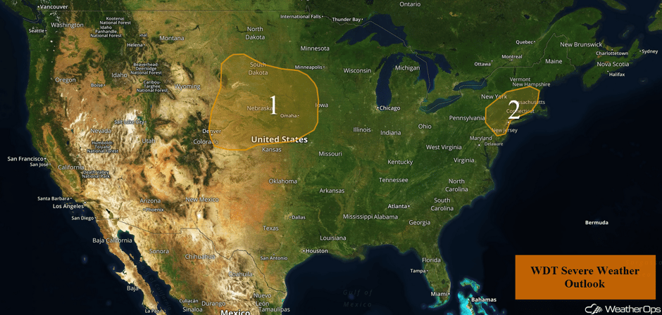 US Hazards
Thunderstorms across the Northern and Central Plains on Wednesday
An area of low pressure moving across the North Central US today will provide a focus for thunderstorm development. Storms will develop along the front with some individual supercells and some clusters. Large hail and damaging winds will be the primary hazards, but an isolated tornado cannot be ruled out.
Major Cities in Region: Rapid City, SD, Pierre, SD, Sioux Falls, IA, Omaha, NE
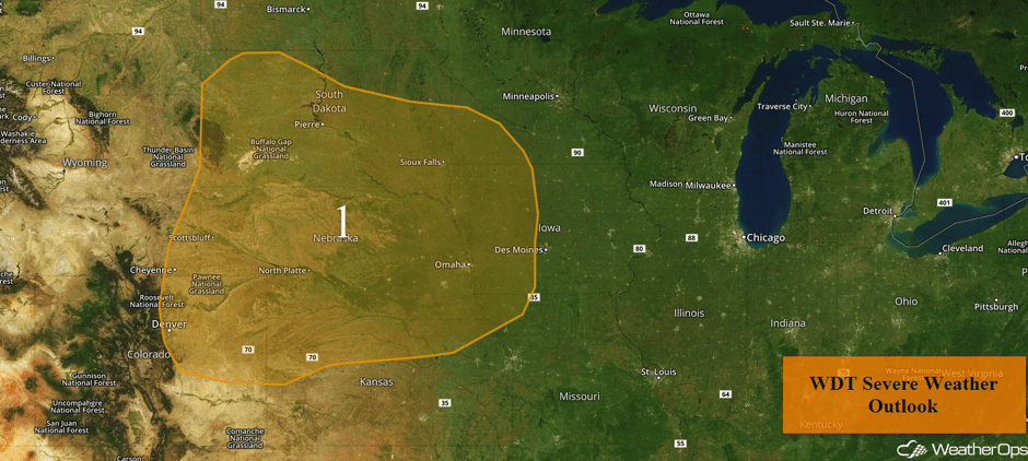 Region 1
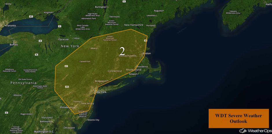
Potential for Thunderstorms Wednesday for Portions of the Northeast
Thunderstorms are forecast to develop during the afternoon in response to plentiful moisture and daytime heating. Scattered thunderstorms will develop with a few of the stronger storms being capable of producing hail and damaging winds.
Update 12:27pm EDT: Thunderstorms capable of large hail and damaging winds SW of Albany, NY
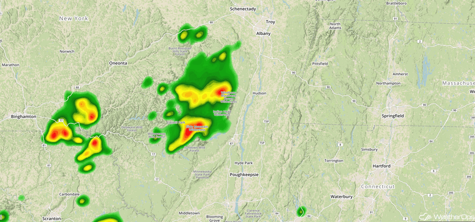 Radar 12:27pm EDT
Update 12:37pm EDT: Severe thunderstorms capable of hail and damaging winds north of New York City.
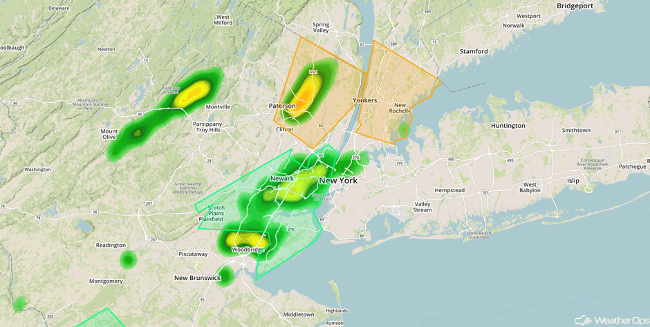 Radar 12:37pm EDT
Major Cities in Region: Philadelphia, PA, New York, NY, Boston, MA
 Region 2
Risk for Excessive Rainfall Wednesday across Northern Florida
A stalled front across northern Florida will be the focus for heavy rainfall on Wednesday. Rainfall amounts of 1-2 inches with locally higher amounts in excess of 3 inches are forecast.
Major Cities in Region: Tallahassee, FL, Tampa, FL, Gainesville, FL
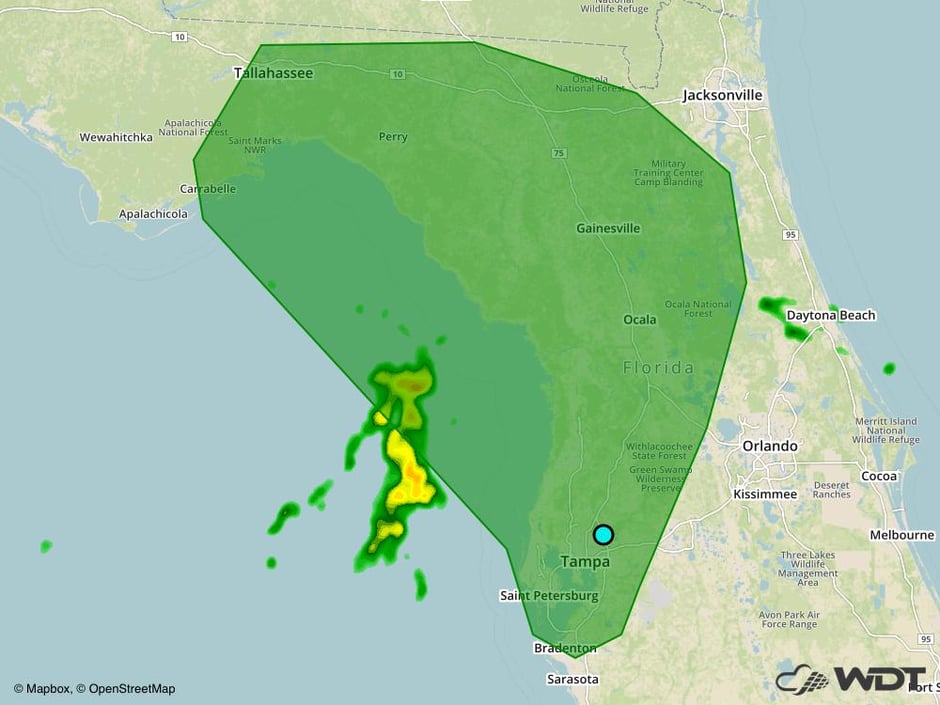 Excessive Rainfall Risk Outline for Wednesday
Excessive Rainfall for Southern California on Wednesday
Moisture is expected to increase across Southern California on Wednesday. With a weak stationary front and upper level low in the region, heavy to excessive rainfall will be possible throughout the day. Rainfall accumulations of 0.5 inch are expected with locally higher amounts in excess of an inch.
Major Cities in Region: San Bernardino, CA
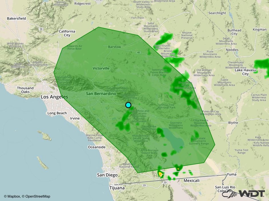 Excessive Rainfall Risk Outline for Wednesday
Potential for Thunderstorms Thursday across the Midwest
The threat for strong to severe thunderstorms will shift eastward into the Midwest on Thursday. The area of low pressure is forecast to continue to progress to the east-northeast accompanied by a shortwave trough aloft. Moist air at the surface is forecast to be present ahead of the cold front as daytime heating increases instability at the surface into the afternoon. As a result, scattered to strong thunderstorms are expected to develop. Large hail, damaging winds, and tornadoes will all be potential hazards with these storms.
Major Cities in Region: St. Louis, MO, Milwaukee, WI, Chicago, IL, Toledo, OH, Detroit, MI
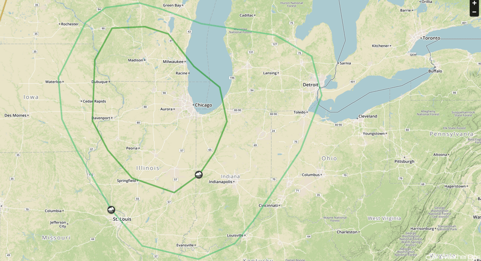 SPC Convective Outlook for Thursday
Thunderstorms for New Mexico and West Texas on Thursday
As a cold front passes through portions of New Mexico and West Texas, instability is forecast to build into the afternoon with increasing moisture. With cooler air aloft behind the front, clusters of thunderstorms may develop. Large hail and damaging winds will be the primary hazards with these storms.
Major Cities in Region: Santa Fe, NM, Amarillo, TX
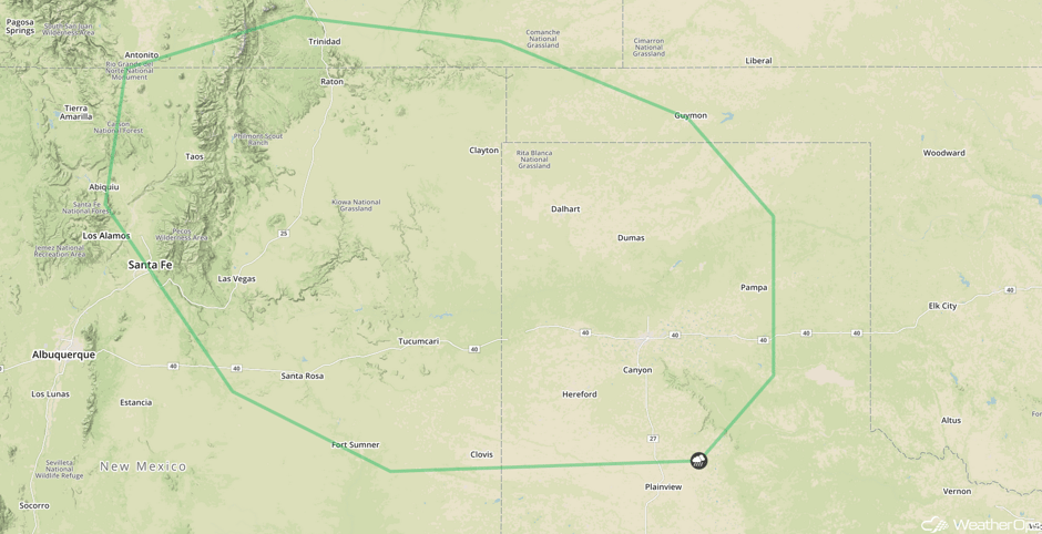 SPC Convective Outlook for Thursday
Thunderstorm Potential Friday from the Northeast to the Appalachians
The area of low pressure and associated cold front from Thursday will continue to move eastward into portions of the northeast with the cold front extending into the Appalachians. Warm, moist air at the surface ahead of the front and a shortwave trough will allow for the development of thunderstorms. Damaging winds will be the primary hazards with these storms.
Major Cities in Region: Nashville, TN, Charleston, WV, Pittsburgh, PA, Buffalo, NY, Albany, NY
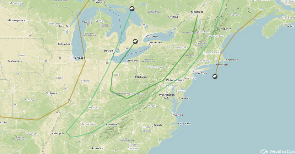 SPC Convective Outlook for Friday
Strong to Severe Thunderstorms for the Central Plains on Friday
With the development of a surface low along a stationary front in the lee of the Rockies, strong to severe thunderstorms may develop along the warm front to the northeast of the low. An increase in the low level jet during the evening will aid in the development of strong to severe thunderstorms in the region, possibly continuing into the overnight hours. Strong winds and large hail will be the primary hazards with these storms.
Major Cities in Region: Denver, CO, Cheyenne, WY, North Platte, NE
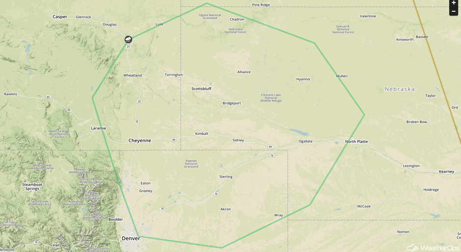 SPC Convective Outlook for Friday
Tropical Update
Shower and thunderstorm activity has decreased in association with a broad area of low pressure extending from the Gulf of Mexico northeastward into Apalachee Bay (green oval). Further development is not expected, but the trough is forecast to move across the southeastern US through Friday.
Further east, a tropical wave is producing an area of disorganized showers and thunderstorms several hundred miles southwest of the Cabo Verde Islands (red oval). Conditions are unfavorable for development as this system moves westward at 10-15 mph.
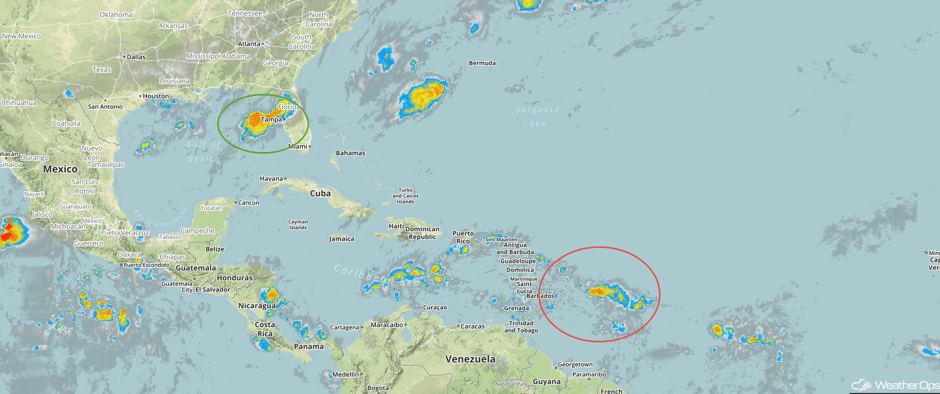 Enhanced Infrared Tropical Satellite
A Look Ahead
Going into the weekend, thunderstorms may develop across the Northeast on Saturday as an area of low pressure and cold front move across the region. Strong winds and hail will be the primary hazards with these storms.
This is just a brief look at current weather hazards. We can provide you site-specific weather forecast information for the purpose of protecting your personnel and assets and to assess your weather risk. Try a 7-day demo right away and learn how timely precision weather information can enhance your bottom line.


