


by David Moran, on Aug 1, 2018 11:05:31 AM
Thunderstorms will continue for the western and central Gulf of Mexico through Wednesday afternoon as an area of low pressure continues to move across the region. An upper level trough will allow for the development of thunderstorms across the eastern US. This activity will also pose a risk for excessive rainfall from the Southeast into the Central Appalachians through Thursday. Daytime heating will allow for the development of thunderstorms from the Desert Southwest into the High Plains. An area low pressure will aid in thunderstorm development across portions of Wyoming, Montana, and Idaho. Building instability and an area of low pressure will support the development of thunderstorms across the Upper Midwest.
- Continued Thunderstorms Wednesday for the Western and Central Gulf of Mexico
- Thunderstorms for the Eastern US on Wednesday
- Excessive Rainfall through Thursday from the Southeast into the Central Appalachians
- Risk for Thunderstorms across the Desert Southwest into the High Plains on Wednesday
- Thunderstorm Potential Wednesday for Wyoming, Montana, and Idaho
- Risk for Thunderstorms for the Upper Midwest on Wednesday
- Thunderstorm Potential Friday for the Northern Plains
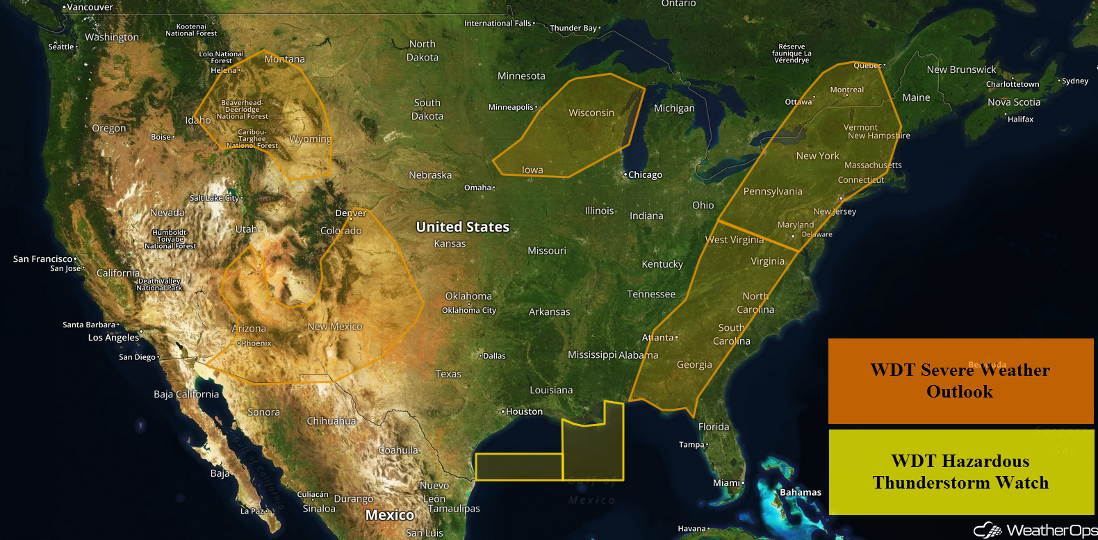
US Hazards
Continued Thunderstorms Wednesday for the Western and Central Gulf of Mexico
Scattered showers and thunderstorms are ongoing in response to a broad area of low pressure. Thunderstorms will continue through mid-afternoon with wind gusts in excess of 40 knots, waterspouts, heavy rain, and frequent lightning potential hazards.
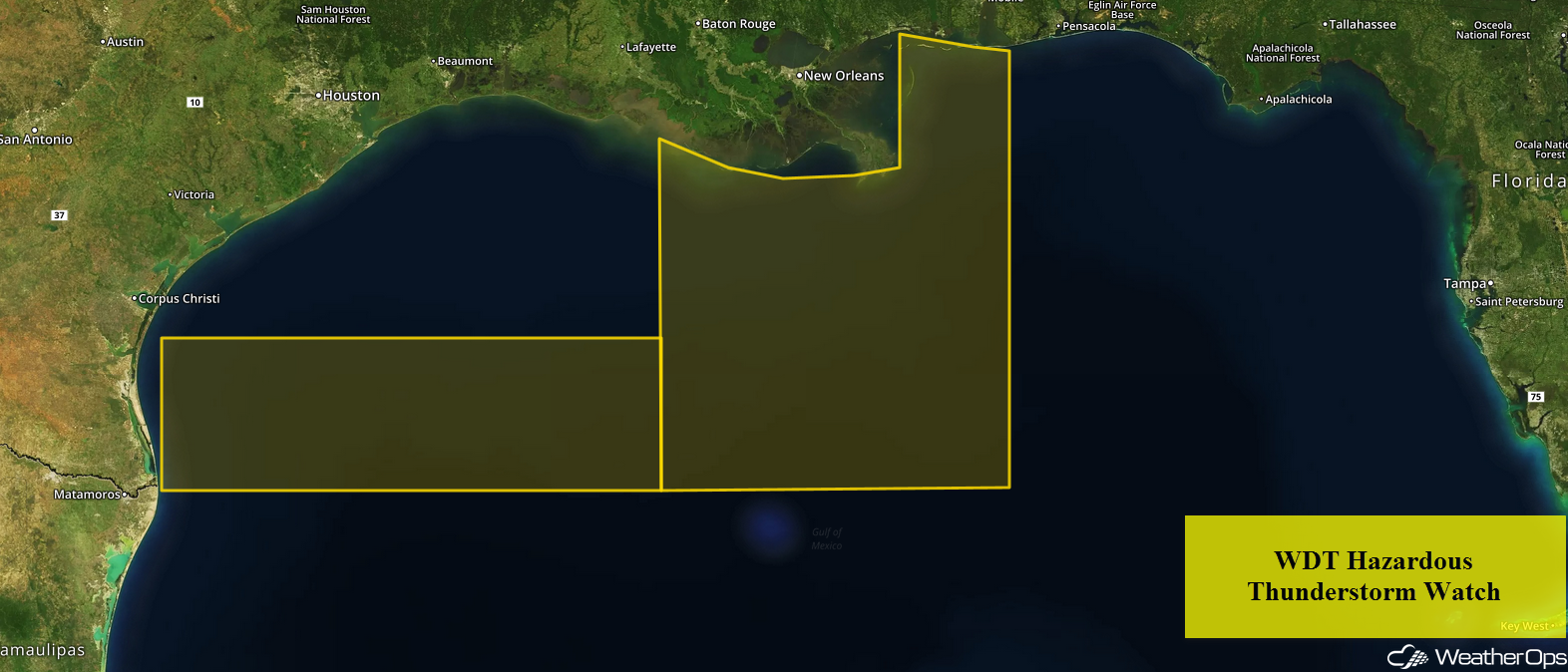
WDT Hazardous Thunderstorm Watch
Thunderstorms for the Eastern US on Wednesday
A trough over the eastern US will remain nearly stationary on Wednesday. Daytime heating and sufficient wind shear will support the development of showers and thunderstorms from the eastern Gulf Coast northward into the Central Appalachians and Northeast. Isolated to scattered severe thunderstorms may develop during the afternoon and evening with severe winds and hail the primary hazards, but an isolated tornado or two cannot be ruled out. The greatest risk will stretch from West Virginia into New York.
Major Cities in Region: Tallahassee, FL, Atlanta, GA, Columbia, SC, Charlotte, NC, Washington, DC, Baltimore, MD, Philadelphia, PA, Pittsburgh, PA, New York, NY, Albany, NY
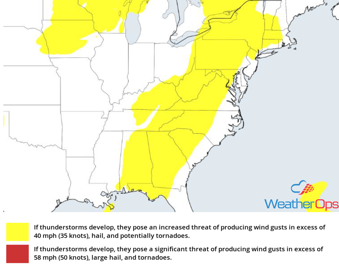
Thunderstorm Risk for Wednesday
Excessive Rainfall through Thursday from the Southeast into the Central Appalachians
In addition to the severe thunderstorm risk described above, there will be a risk for excessive rainfall through Thursday. Two day rainfall totals of 1-2 inches with locally higher amounts in excess of 3 inches are forecast. Given recent rainfall, there will be a risk for flooding and local runoff.
Major Cities in Region: Tallahassee, FL, Atlanta, GA, Asheville, NC, Blacksburg, VA
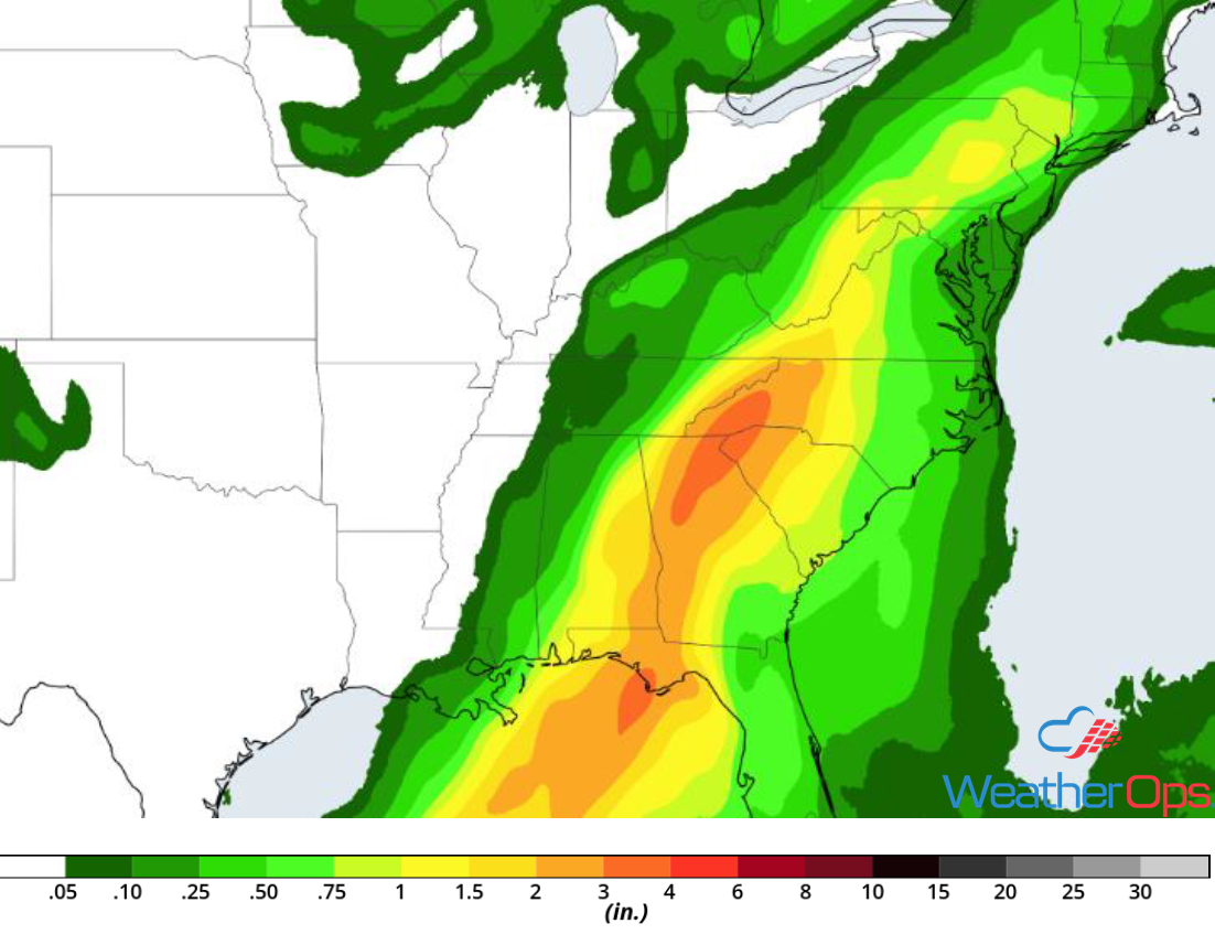
Rainfall Accumulation through Thursday
Risk for Thunderstorms across the Desert Southwest into the High Plains on Wednesday
Strong daytime heating across the Four Corners region will allow for the development of showers and thunderstorms during the afternoon. Storms are expected to develop from Arizona eastward through New Mexico and the Oklahoma/Texas Panhandles. This activity will pose a low risk for severe winds and hail. Activity should weaken after dark, but the severe threat may persist after sunset.
Major Cities in Region: Phoenix, AZ, Tucson, AZ, Truth or Consequences, NM, Albuquerque, NM, Roswell, NM
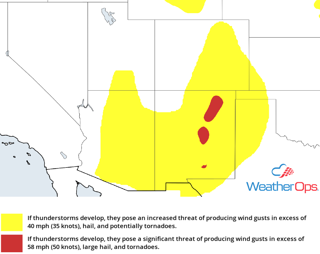
Thunderstorm Risk for Wednesday
Thunderstorm Potential Wednesday for Wyoming, Montana, and Idaho
A shortwave trough is forecast to track from the Northern Rockies southeastward into the High Plains of Montana and Wyoming this afternoon. Isolated showers and thunderstorms will develop with damaging winds the primary hazard before dark.
Major Cities in Region: Butte, MT, Idaho Falls, MT, Helena, MT, Billings, MT, Casper, WY
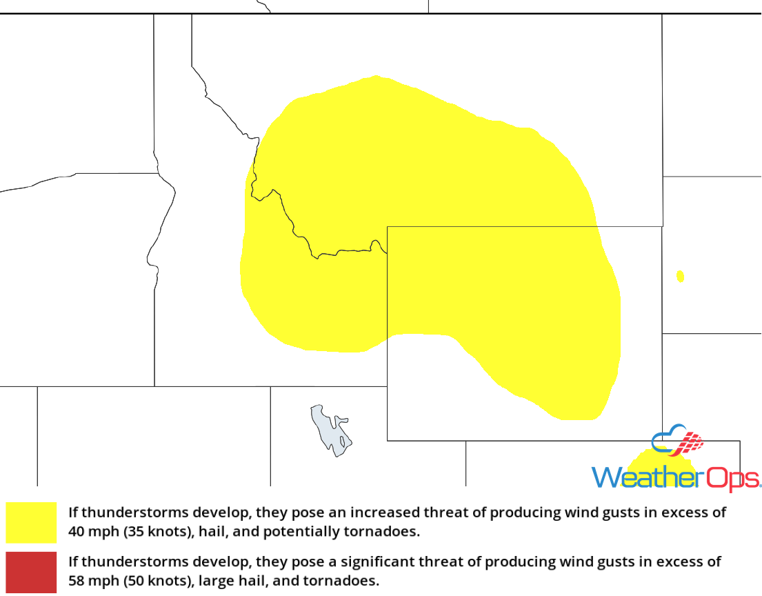
Thunderstorm Risk for Wednesday
Risk for Thunderstorms for the Upper Midwest on Wednesday
An upper level trough is forecast to dig across the Upper Midwest on Wednesday. Daytime heating and moisture will allow instability to build across southeast Minnesota into much of Wisconsin and portions of Iowa. This will allow for the development of thunderstorms capable of severe wind and hail.
Major Cities in Region: Rochester, MN, Waterloo, IA, Cedar Rapids, IA, Dubuque, IA, Wausau, WI, Madison, WI, Green Bay, WI, Milwaukee, WI
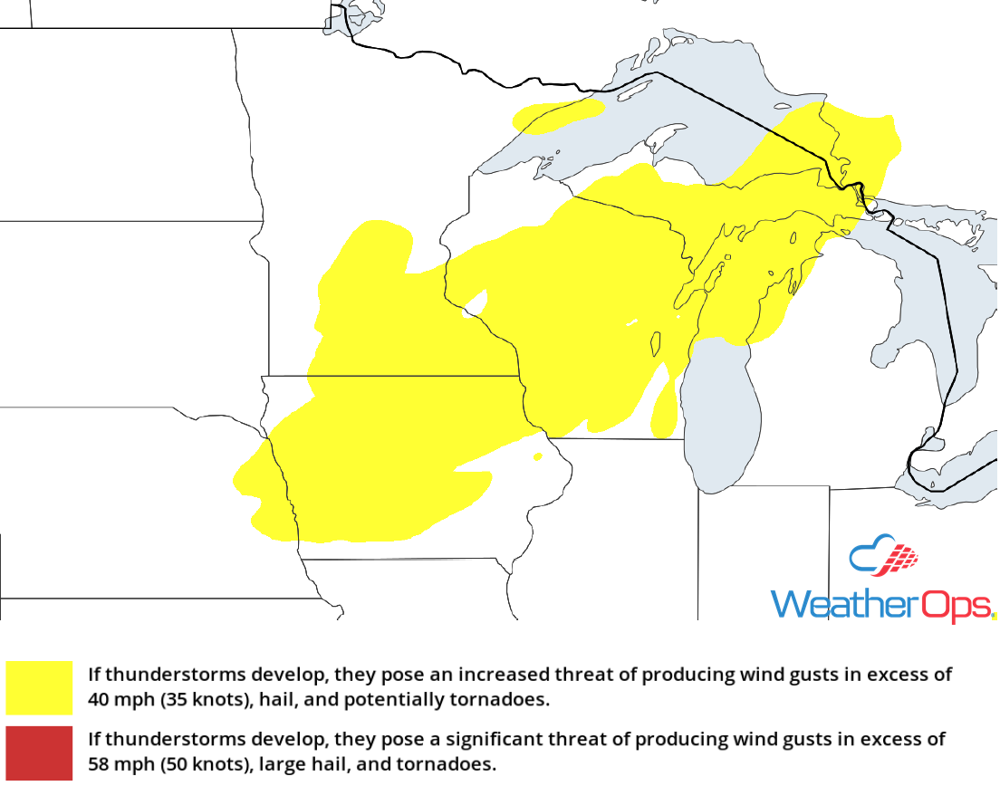
Thunderstorm Risk for Wednesday
Thunderstorm Potential Friday for the Northern Plains
Southwesterly upper level winds will overspread the Northern Plains on Friday. With instability building across the Dakotas and into Minnesota, severe thunderstorms are expected to develop. While there is some uncertainty in the degree of coverage of storms, any storms that develop will have the potential to produce very large hail, damaging winds, and tornadoes.
Major Cities in Region: Aberdeen, SD, Grand Forks, ND, Fargo, ND, International Falls, MN
SPC Convective Outlook for Friday
A Look Ahead
Showers and thunderstorms may develop from the Upper Midwest into the Central Plains on Saturday ahead of a cold front. By Sunday, showers will move into portions of the Upper Great Lakes. Another round of showers and thunderstorms will develop across the Upper Midwest and Great Lakes on Monday. On Tuesday, a cold front will be the focus for thunderstorms across the Great Lakes and Ohio Valley.
