


by David Moran, on Apr 4, 2018 11:13:22 AM
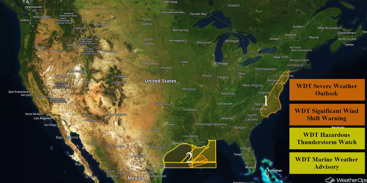
Snow will continue for the Great Lakes through late Wednesday morning. Thunderstorms are expected for portions of the Mid Atlantic on Wednesday along a cold front. Elevated winds and seas will continue for portions of the Gulf of Mexico through Thursday morning in association with a cold front.
- Snow Continuing Wednesday Morning for the Great Lakes
- Thunderstorms for the Mid Atlantic on Wednesday
- Elevated Winds and Seas through Thursday Morning for Portions of the Gulf of Mexico
- Potential for Snow from the Northern Rockies into the Northern and Central Plains Late Thursday into Friday
- Excessive Rainfall Friday and Saturday for Northwest California
- Risk for Thunderstorms for the Arklatex on Friday
- Freezing Rain and Snow Friday Afternoon through Early Saturday Morning for Portions of the Plains
 US Hazards

Snow Continuing Wednesday Morning for the Great Lakes
Snow is continuing for the Great Lakes as an area of low pressure moves eastward. Snowfall totals of 6-12 inches with locally higher amounts in excess of 15 inches are expected. Winds gusting in excess of 30 mph will allow for blowing snow and low visibilities.
Major Cities in Region: Traverse City, MI, Sault Ste. Marie, MI
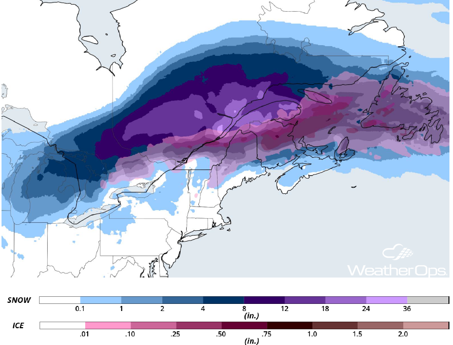 Snowfall Accumulation for Wednesday
Thunderstorms for the Mid Atlantic on Wednesday
A cold front is expected to move across the region today, bringing a line of showers and thunderstorms with it. Daytime heating, as well as sufficient moisture across the region, will allow this activity to intensify. By early afternoon, these storms will pose a primarily severe wind risk. Large hail and an isolated tornado cannot be ruled out. These storms will continue along the front until around sunset when the cold front moves offshore.
Major Cities in the Region: Wilmington, NC, Raleigh, NC, Norfolk, VA, Richmond, VA, Atlantic City, NJ, Philadelphia, PA
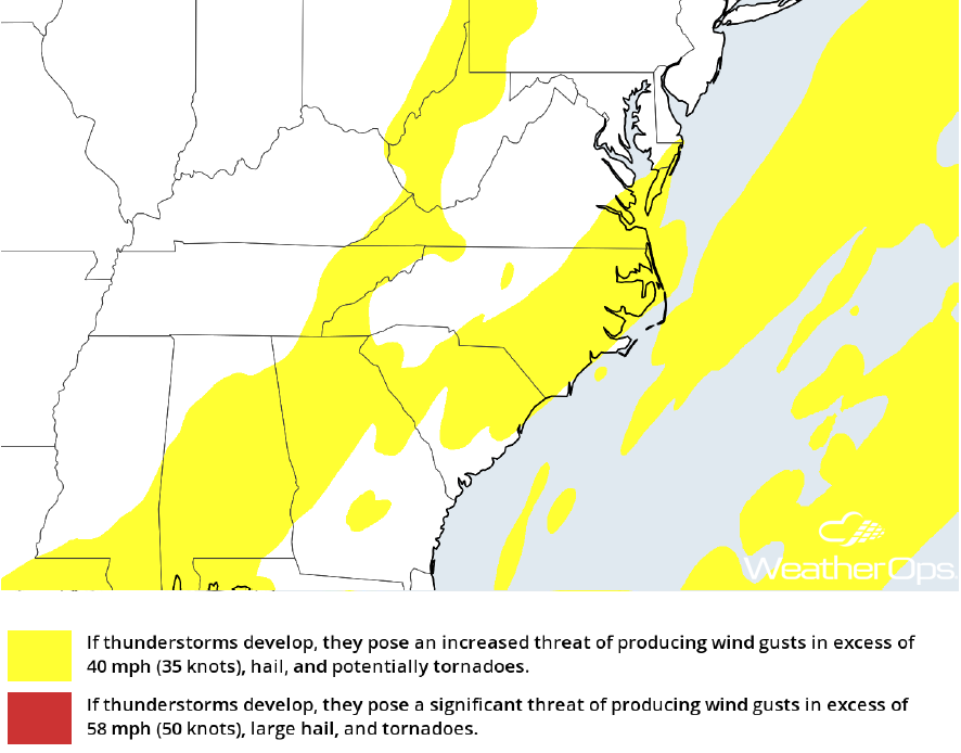 Thunderstorm Forecast for Wednesday
Elevated Winds and Seas through Thursday Morning for Portions of the Gulf of Mexico
A cold front moving off the Texas coast will allow for elevated winds and seas across portions of the Gulf of Mexico through Thursday morning. Winds will be southerly at 10-20 knots ahead of the front. Behind the front, winds will be northeasterly at 20-30 knots. Seas will be 4-7 feet near the shore and 6-9 feet in the deeper waters. In addition, thunderstorms are likely ahead of the front. Winds in excess of 50 knots, heavy rain, frequent lightning, and heavy rain will all be potential hazards with these storms.
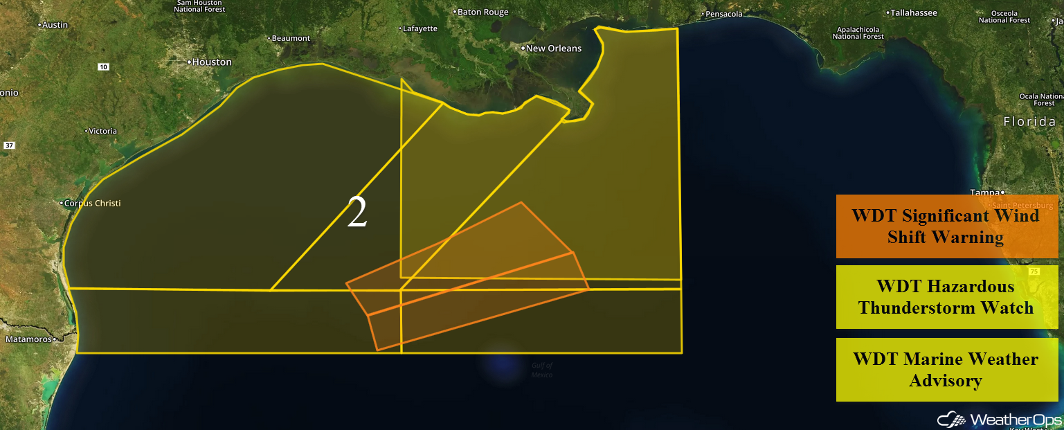 Region 2
Potential for Snow from the Northern Rockies into the Northern and Central Plains Late Thursday into Friday
An area of low pressure is forecast to develop across the Northern Rockies and move southeastward throughout the day. With the development of the low, upslope winds along the warm front will lead to snow across the region. Accumulations of 4-6 inches with locally higher amounts in excess of 8 inches are expected in the valleys. In the higher elevations, 6-10 inches with locally higher amounts in excess of a foot are expected.
Major Cities in Region: Helena, MT, Great Falls, MT, Billings, MT
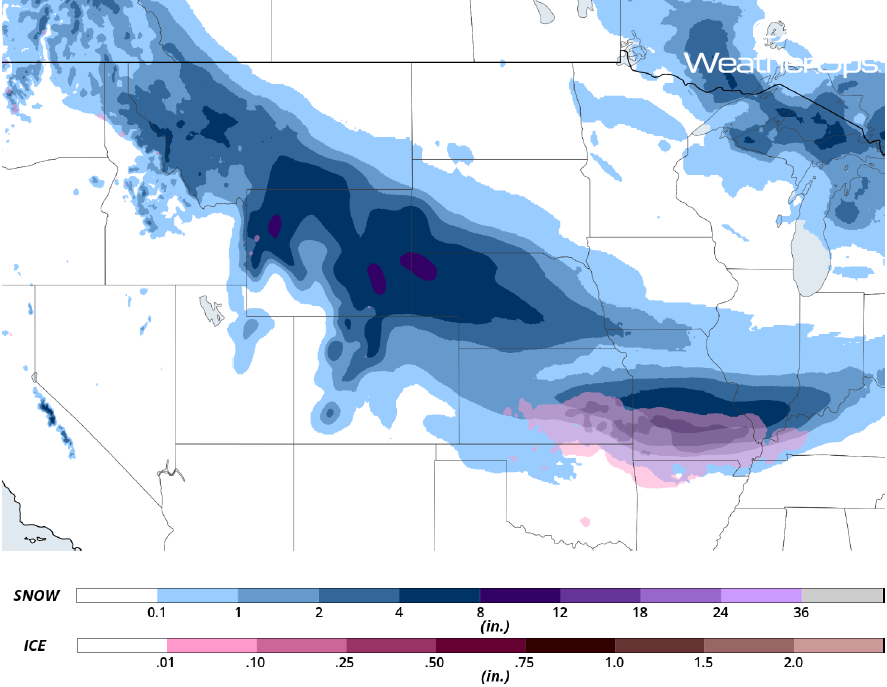 Snowfall Accumulation for Friday
Excessive Rainfall Friday and Saturday for Northwest California
A Pacific low will bring showers and thunderstorms to portions of California on Friday. Rainfall accumulations of 1-3 inches with locally higher amounts in excess of 4 inches are forecast. This will lead to a risk for flash flooding and local runoff.
Major Cities in Region: Eureka, CA, San Francisco, CA, Sacramento, CA
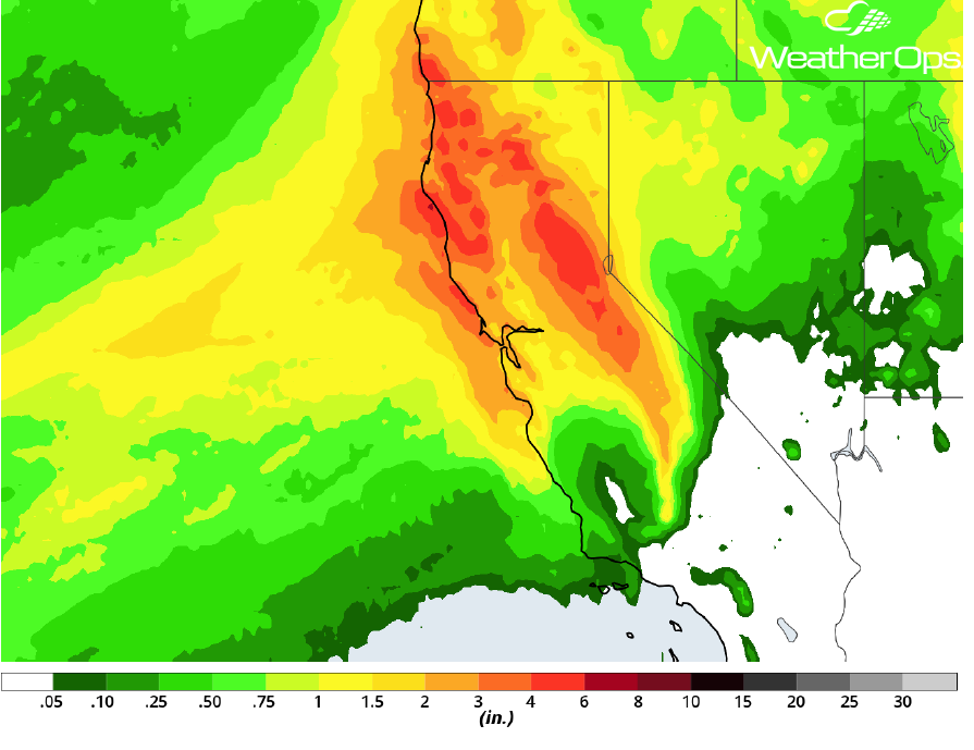 Rainfall Accumulation for Friday and Saturday
Risk for Thunderstorms for the Arklatex on Friday
A developing shortwave trough will move through Texas and lift into the Lower Mississippi Valley late Friday into early Saturday. Strong convergence ahead of the front and ample moisture from the Gulf of Mexico should support shower and thunderstorm development by Friday evening. These storms will advance eastward overnight with damaging winds the primary hazard, but large hail and tornadoes cannot be ruled out.
Major Cities in Region: Dallas, TX, Shreveport, LA, Monroe, LA
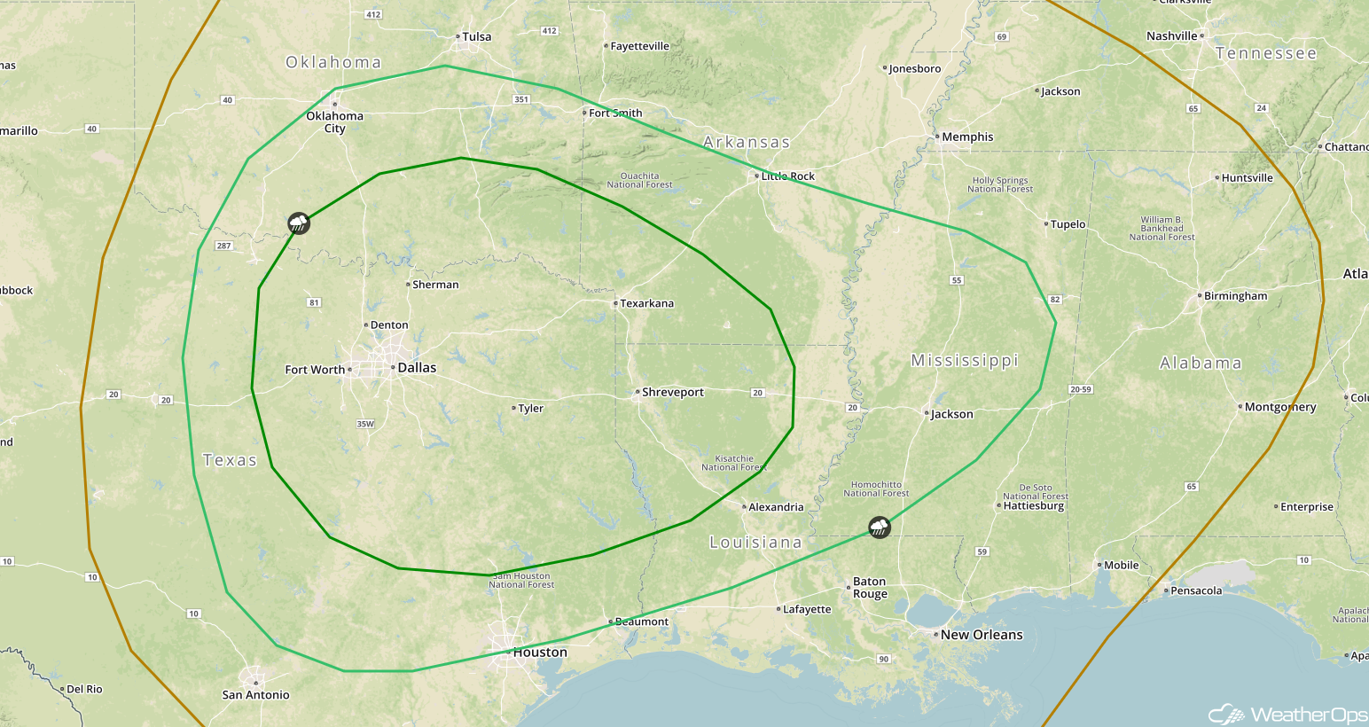 SPC Convective Outlook for Friday
Freezing Rain and Snow Friday Afternoon through Early Saturday Morning for Portions of the Plains
An area of low pressure is forecast to move through southern Missouri and Illinois with precipitation likely beginning as rain along the warm front during the morning hours. As the cold front moves through the region, temperatures will fall below freezing and precipitation will become a wintry mix before fully changing over to snow. Freezing rain accumulations will be less than a quarter of an inch. Snowfall accumulations will range 2-6 inches.
Major Cities in Region: Joplin, MO, Springfield, MO, Paducah, KY
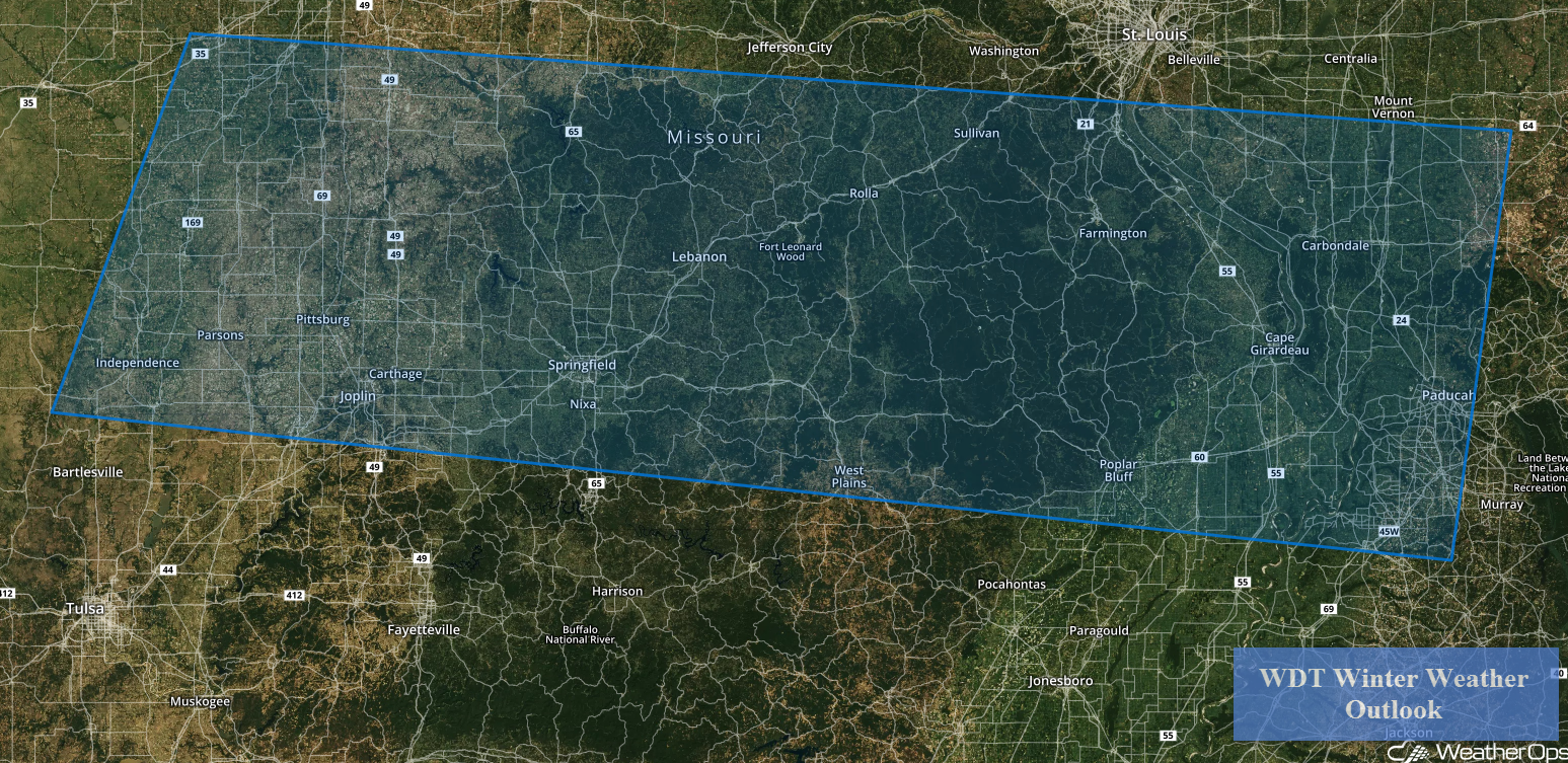 Freezing Rain and Snow Risk for Friday and Saturday
A Look Ahead
The wintry mix across portions of the Plains on Friday will continue to move eastward into the Mid Atlantic on Saturday. Across the Northern Plains, an area of low pressure will develop, bringing snow to the region Sunday into Monday.
This is just a brief look at current weather hazards. We can provide you site-specific weather forecast information for the purpose of protecting your personnel and assets and to assess your weather risk. Try a 7-day demo right away and learn how timely precision weather information can enhance your bottom line.
