National Weather Summary for Tuesday, September 5, 2017
by David Moran, on Sep 5, 2017 10:39:49 AM
Strong to severe thunderstorms may develop Tuesday from the Northeast into the Lower Mississippi Valley ahead of a cold front.
- Thunderstorms from the Northeast to the Lower Mississippi Valley on Tuesday
- Risk for Thunderstorms Wednesday for Portions of the Mid Atlantic
- Thunderstorm Potential for the Northern Cascades on Wednesday
- Tropical Update
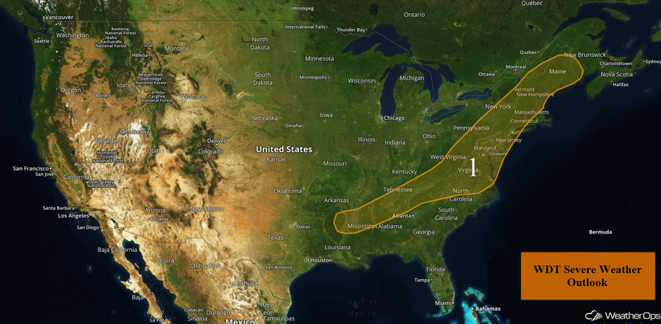 US Hazards
Thunderstorms from the Northeast to the Lower Mississippi Valley on Tuesday
There will be a chance for strong to severe thunderstorms from the far Northeast southward into the Lower Mississippi Valley on Tuesday. Morning showers and thunderstorms are expected to increase in coverage and intensity during the afternoon hours ahead of a cold front. Strong to damaging winds will be the primary hazard from the late morning into the evening as the storms shift eastward. There will be an isolated tornado threat across portions of the Northeast during the afternoon.
Major Cities in Region: Jackson, MS, Knoxville, TN, Raleigh, NC, Washington, DC, Philadelphia, PA, New York, NY, Concord, NH, Augusta, ME
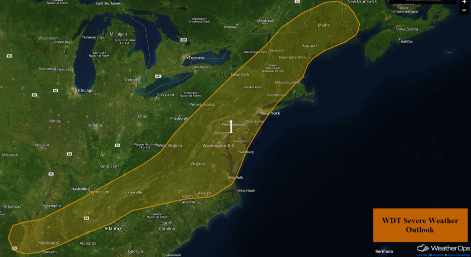 Region 1
Risk for Thunderstorms Wednesday for Portions of the Mid Atlantic
By Wednesday, the cold front described above will continue to track eastward toward the East Coast. Out ahead of this front, warm moist air will continue to be pulled into the Mid Atlantic. With this warm, moist air in place, instability will increase during the afternoon resulting in scattered strong to severe thunderstorms along and ahead of the front. Damaging winds, frequent lightning, and heavy rain appear to be the primary hazards with the stronger storms. In addition, rainfall amounts of 0.50-1.00 inch are likely with locally higher amounts in excess of 1.50 inches.
Major Cities in Region: Columbia, SC, Raleigh, NC, Richmond, VA, Norfolk, VA
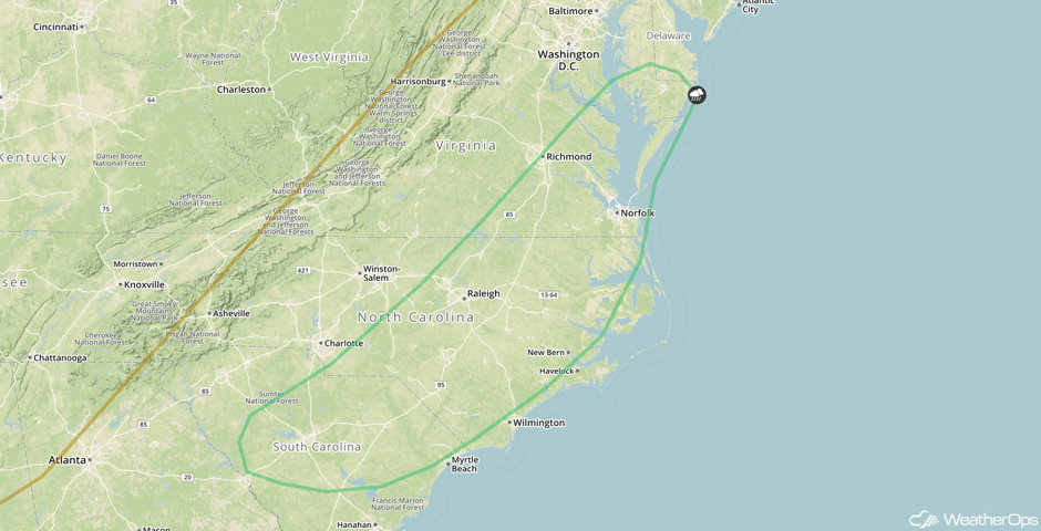 SPC Convective Outlook for Wednesday
Thunderstorm Potential for the Northern Cascades on Wednesday
There will be a chance for some strong to severe thunderstorms across the Northern Cascades on Wednesday. Deep low level moisture will spread across the region as the remnants of a tropical system track across the region. With this moisture in place and enough forcing from this remnant low, an increase in shower and thunderstorm activity is forecast during the afternoon and evening hours. The primary threat with any of these storms will be damaging winds, frequent lightning, and heavy rain.
Major Cities in Region: Reno, NV
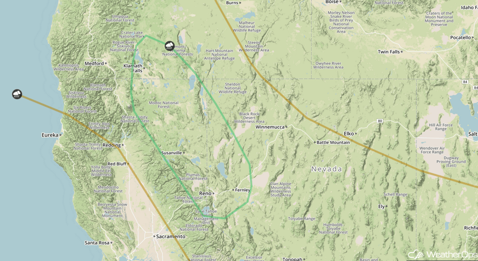 SPC Convective Outlook for Wednesday
Tropical Update
The center of Hurricane Irma (red oval) is located about 225 miles east of Antigua and is continuing to move westward at 14 mph. This general motion is expected to continue today, followed by a turn to the west-northwest tonight. On the forecast track, the center of Irma will move near or over portions of the northern Leeward Islands tonight or early Wednesday. Irma continues to strengthen with sustained winds near 180 mph with higher gusts. Some fluctuations in intensity are likely during the next day or two with Irma fluctuating between a category 4 or 5 hurricane.
Tropical Storm Jose (blue oval) is located 1500 miles east of the Lesser Antilles and is moving west-northwestward at 13 mph. Movement is expected to be westward or west-northwestward while increasing in forward speed. Maximum sustained winds are near 40 mph. Jose could become a hurricane by Friday.
An area of low pressure located over the southwestern Gulf of Mexico (green oval) is producing numerous showers and thunderstorms. Environmental conditions are conducive for gradual development, and this system is likely to become a tropical depression during the next few days while it meanders over the southwestern Gulf of Mexico. Regardless of development, heavy rains associated with this disturbance are likely over portions of eastern Mexico during the remainder of the week.
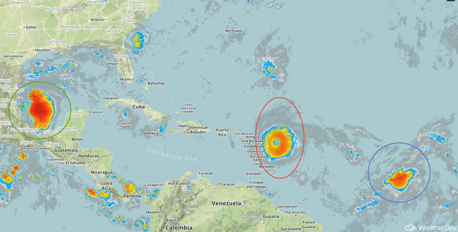 Enhanced Infrared Tropical Satellite
A Look Ahead
There will be a risk for heavy to excessive rainfall across southern portions of Florida on Saturday as Hurricane Irma makes its approach toward the region. Rain and thunderstorms will spread across southern Florida by the afternoon hours bringing a threat for torrential downpours and strong winds. At this time, model guidance currently suggests that 2-4 inches with locally higher amounts in excess of 6 inches are forecast across the region. This will lead to widespread flooding and excessive runoff.
This is just a brief look at current weather hazards. We can provide you site-specific weather forecast information for the purpose of protecting your personnel and assets and to assess your weather risk. Try a 7-day demo right away and learn how timely precision weather information can enhance your bottom line.


