National Weather Summary for Tuesday, September 19, 2017
by David Moran, on Sep 19, 2017 10:59:27 AM
Severe thunderstorms are expected across the North Central Plains on Wednesday as an area of low pressure moves across the region. Tropical storm conditions are forecast for portions of the Northeast as Hurricane Jose approaches. A few thunderstorms may develop across portions of Texas ahead of a dryline.
- Severe Thunderstorms across the North Central Plains on Tuesday
- Tropical Storm Conditions Expected Tuesday and Wednesday across the Northeast
- Thunderstorm Potential for Portions of Texas on Tuesday
- Risk for Thunderstorms Wednesday from the Great Lakes through the Midwest
- Thunderstorms for North Dakota and Minnesota on Thursday
- Tropical Update
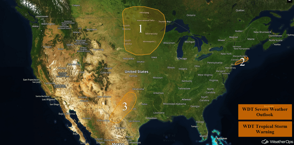 US Hazards
Severe Thunderstorms across the North Central Plains on Tuesday
A strong area of low pressure will move across the Northern US on Tuesday, bringing a risk of thunderstorms to portions of the Upper Midwest. At the surface, moisture and instability increase ahead of a cold front. These conditions will favor the development of supercells as well as bowing line segments. Large hail and damaging winds will be the primary hazards, but a few isolated tornadoes cannot be ruled out. Later tonight, any remaining activity will pose a risk for damaging winds, but the risk for hail and tornadoes should diminish after dark. The areas at greatest risk for severe impacts should stretch across the eastern half of the Dakotas, along the Minnesota border, and into North-Central Minnesota.
Update 1:44pm CDT: Severe thunderstorms capable of hail and damaging winds developing across portions of North Dakota and South Dakota.
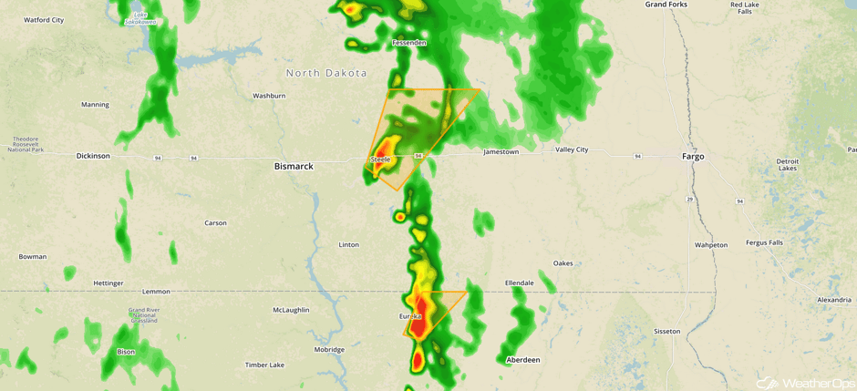 Radar 1:44pm CDT
Major Cities in Region: Grand Forks, ND, Fargo, ND, Sioux Falls, SD, International Falls, MN, Minneapolis, MN
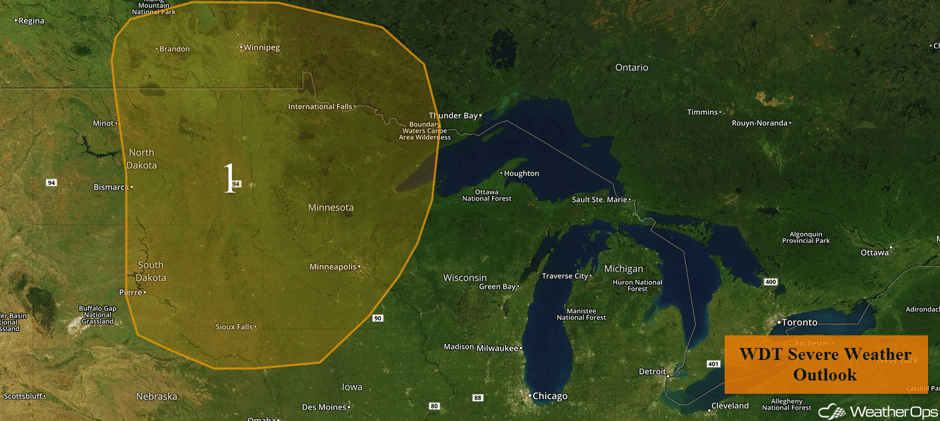 Region 1
Tropical Storm Conditions Expected Tuesday and Wednesday across the Northeast
Hurricane Jose continues to track northward over the western Atlantic with sustained winds of 75 mph near the center. The center is forecast to remain well offshore the Northeast over the next couple of days, however, the outer edges of the tropical storm force winds may impact Long Island into eastern Massachusetts. Elevated winds of 35-45 mph, with gusts in excess of 55 mph, will spread over eastern Long Island late Tuesday. The greatest chance for tropical force conditions over Cape Cod start Wednesday morning. Periods of heavy rainfall from the outer rainbands will produce a threat for minor flooding across the area through Thursday morning. Rainfall amounts of 2-4 inches with locally higher amounts in excess of 5 inches are forecast. Minor storm surge will also be a concern along the southern coast of Long Island as well.
Major Cities in Region: New London, CT, Newport, RI
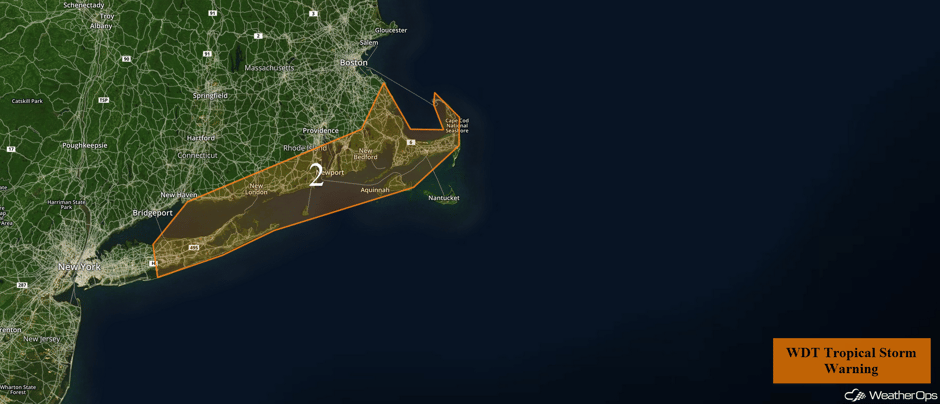 Region 2
Thunderstorm Potential for Portions of Texas on Tuesday
A dryline across portions of southwestern and central Texas will be the focus for thunderstorm development on Tuesday. With warm moist air ahead of the dryline and daytime heating creating ample instability across the region, showers and thunderstorms are forecast to develop across the region this afternoon. Although wind shear will be marginal at best, some of these thunderstorms that develop could become strong to severe in nature with a mix of supercells and clusters of thunderstorms into the early evening. Hail and damaging winds will be the primary hazards with the stronger storms. Activity is expected to dissipate rapidly after the sun sets.
Major Cities in Region: Odessa, TX, Midland, TX, Abilene, TX, Wichita Falls, TX, Lawton, OK
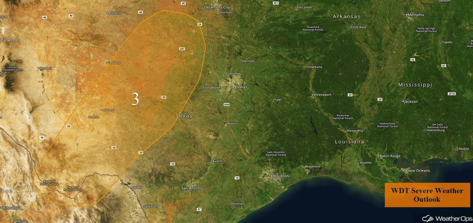 Region 3
Risk for Thunderstorms Wednesday from the Great Lakes through the Midwest
A cold front will progress across the region on Wednesday, with a few thunderstorms along the front likely during the morning hours. This will likely limit thunderstorm development later in the day, but instability should be sufficient for the development of a few thunderstorms. Large hail and damaging winds will be the primary hazards with these storms.
Major Cities in Region: Kansas City, MO, Cedar Rapids, IA, Green Bay, WI
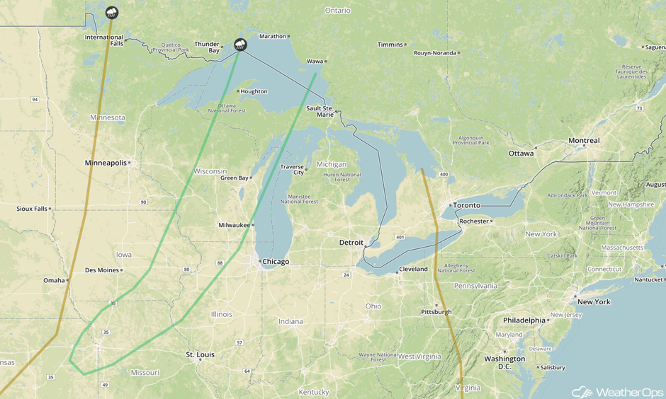 SPC Convective Outlook for Wednesday
Thunderstorms for North Dakota and Minnesota on Thursday
The environment for thunderstorm activity will be fairly marginal, but a low level jet intensifying across the region and a front lifting northward will promote areas of thunderstorms during the evening and nighttime hours. Large hail and damaging winds will be the primary hazards with these storms.
Major Cities in Region: Grand Forks, ND, Fargo, ND, International Falls, MN, Duluth, MN
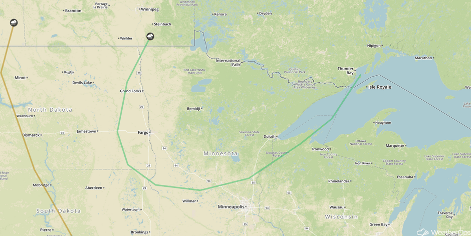 SPC Convective Outlook for Thursday
Tropical Update
Hurricane Jose (green oval) is still a hurricane with sustained winds of 75 mph. The center of Jose is 235 miles east-northeast of Cape Hatteras, North Carolina and is moving northward at 9 mph. This general motion is expected to continue through today with a turn to the northeast expected tonight. Little change in intensity is expected but should gradually weaken on Wednesday.
Hurricane Maria (red oval) is currently located 115 miles west of Guadeloupe and moving west-northwestward at 10 mph. On the current track, the eye of Maria will move over the northeastern Caribbean today and then pass over or near the Virgin Islands and Puerto Rico on Wednesday. Some fluctuations in intensity are expected, but Maria is expected to remain a category 4 or 5 hurricane until it moves near or over the Virgin Islands and Puerto Rico. Maximum sustained winds are at 160 mph with higher gusts.
The remnants of Lee (blue oval) are located between the Cabo Verde Islands and the Leeward Islands. Environmental conditions could be marginally conducive for redevelopment of a tropical cyclone by late in the week while the system moves northwestward to northward over the central Atlantic.
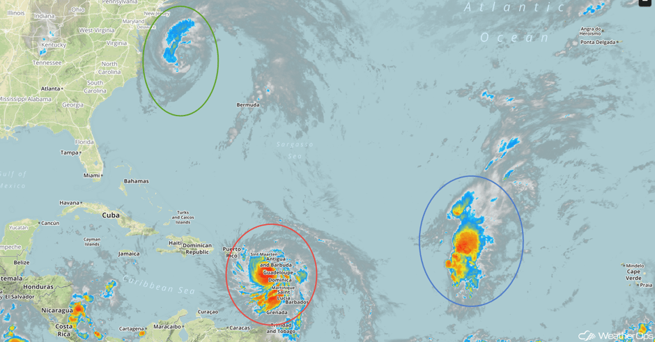 Enhanced Infrared Tropical Satellite
A Look Ahead
As the area of low pressure continues to intensify over the Northern Plains on Friday, thunderstorms may develop across North Dakota and Minnesota. This system will continue to move eastward across the Midwest on Saturday, shifting the severe weather threat eastward. By Sunday, the threat will expand southward into the Central Plains. As the cold front slowly moves eastward, thunderstorms may move into portions of the western Great Lakes on Monday.
This is just a brief look at current weather hazards. We can provide you site-specific weather forecast information for the purpose of protecting your personnel and assets and to assess your weather risk. Try a 7-day demo right away and learn how timely precision weather information can enhance your bottom line.


