


by David Moran, on Oct 9, 2018 11:17:30 AM
A cold front will serve as a focus for thunderstorm development from Texas into the Upper Mississippi Valley on Tuesday. Some of this activity may pose a risk for excessive rainfall from Texas into the Great Lakes. Elevated winds and seas will continue for portions of the Gulf of Mexico in advance of Hurricane Michael. Snow is expected across the Central Plains and Upper Midwest through Thursday as an area of low pressure moves northeastward.
- Thunderstorms from Texas into the Upper Mississippi Valley on Tuesday
- Excessive Rainfall Tuesday from Texas into the Great Lakes
- Elevated Winds and Seas for the Gulf of Mexico through Thursday Morning
- Snow through Thursday from the Central Plains into the Upper Midwest
- Potential for Thunderstorms across the Midwest on Wednesday
- Risk for Excessive Rainfall Wednesday across the Great Lakes
- Excessive Rainfall for the Southeast Wednesday and Thursday
- Tropical Update
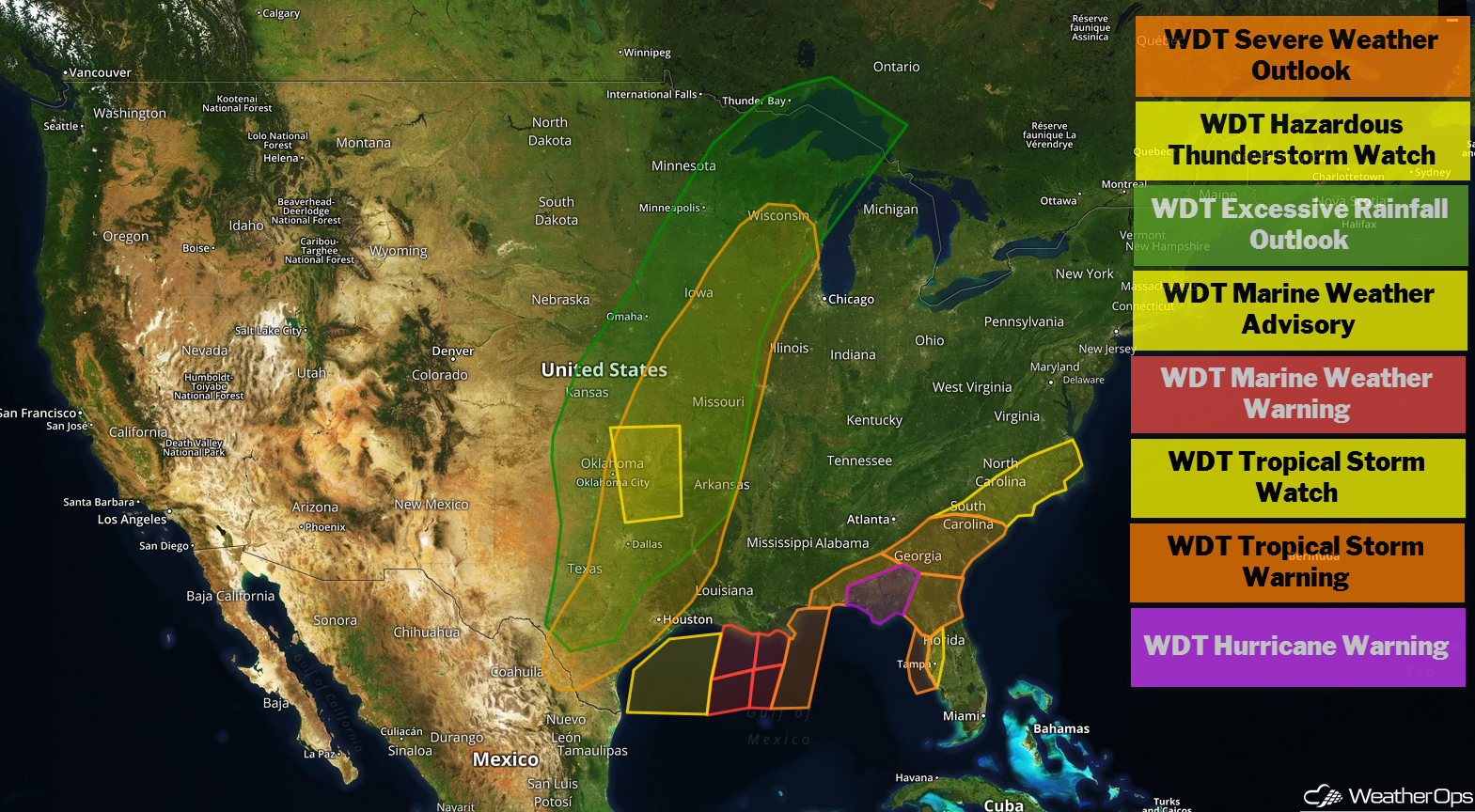
US Hazards
Thunderstorms from Texas into the Upper Mississippi Valley on Tuesday
An area of low pressure and cold front will slowly track eastward across the central US on Tuesday, bringing a risk of thunderstorms from South Texas northward into the Upper Mississippi Valley. Conditions will be favorable for the development of strong to severe thunderstorms with damaging winds the primary hazard. Isolated instances of large hail and isolated tornadoes cannot be ruled out.
Major Cities in Region: Del Rio, TX, Dallas, TX, Oklahoma City, OK, Kansas City, MO, Des Moines, IA
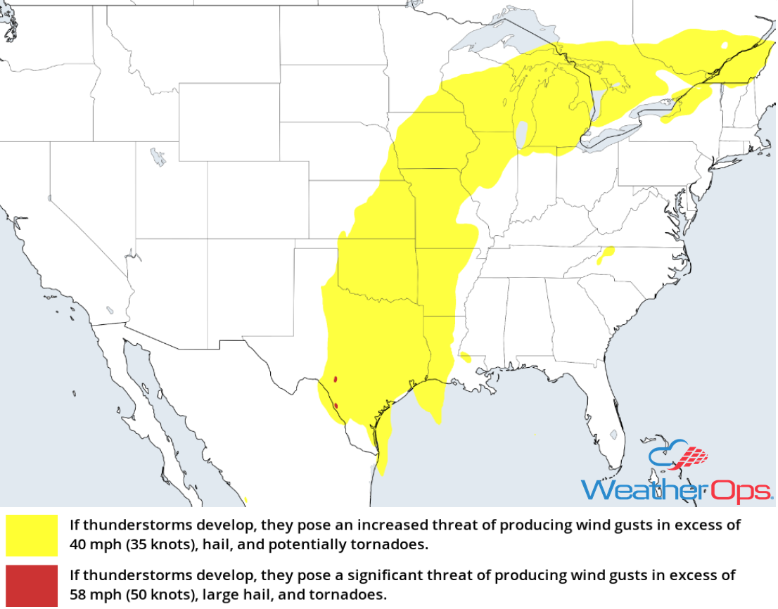
Thunderstorm Risk for Tuesday
Excessive Rainfall Tuesday from Texas into the Great Lakes
In addition to the thunderstorm risk described above, there will be a potential for excessive rainfall. Rainfall amounts of 2-4 inches with locally higher amounts in excess of 5 inches are expected. Those areas that received heavy rain on Monday will be under an increased risk for flooding.
Major Cities in Region: Dallas, TX, Oklahoma City, OK, Kansas City, MO, Des Moines, IA, Wausau, WI
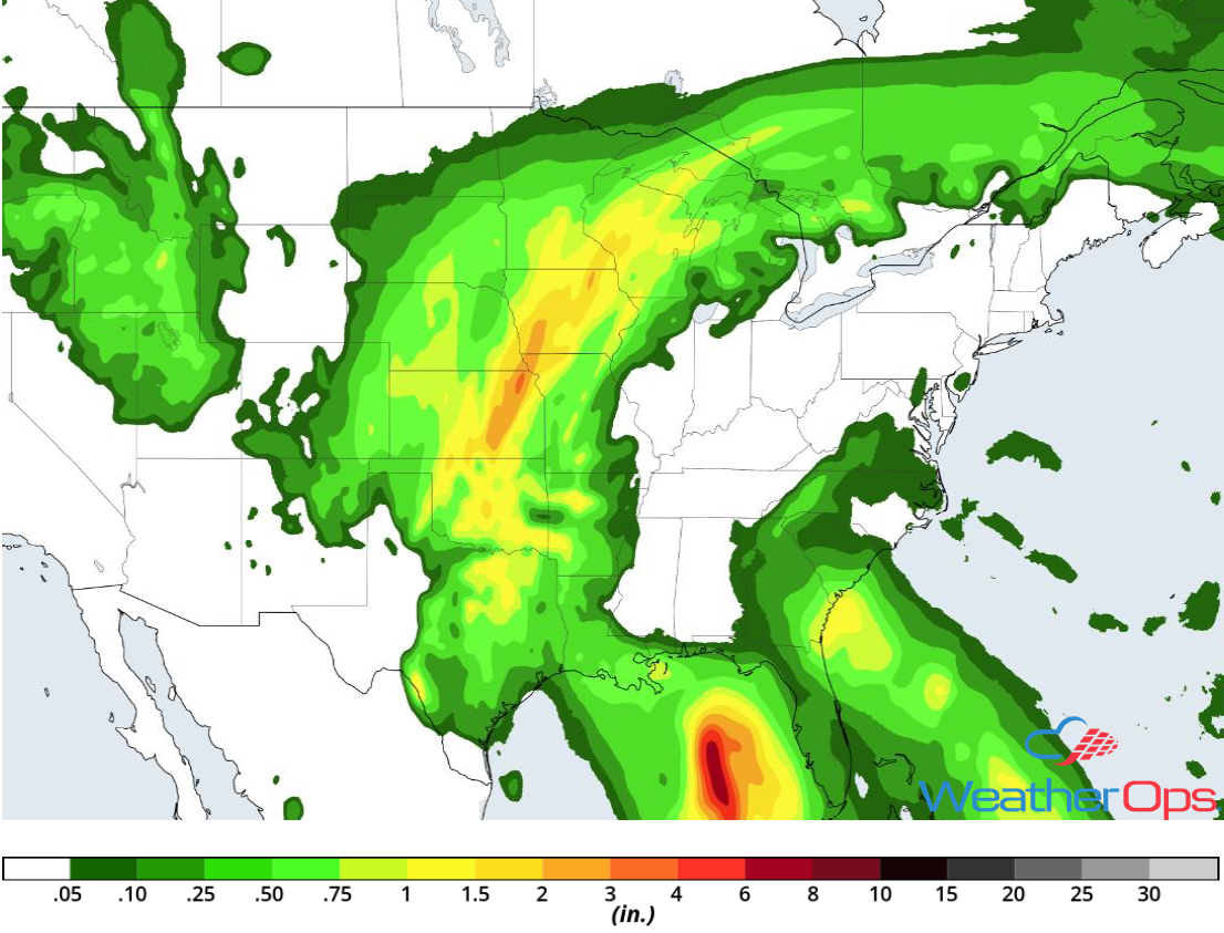
Rainfall Accumulation for Tuesday
Elevated Winds and Seas for the Gulf of Mexico through Thursday Morning
As Hurricane Michael continues to move northward, elevated winds and seas are expected across portions of the northern Gulf of Mexico through Thursday. Winds will range 15-25 knots with higher gusts across western and central portions of the region. Across the easternmost areas, winds will range 35-45 knots with gusts in excess of 55 knots. Seas will range 7-10 feet in the western portions of the region and 12-18 feet further east. In addition, there will be a risk for waterspouts.
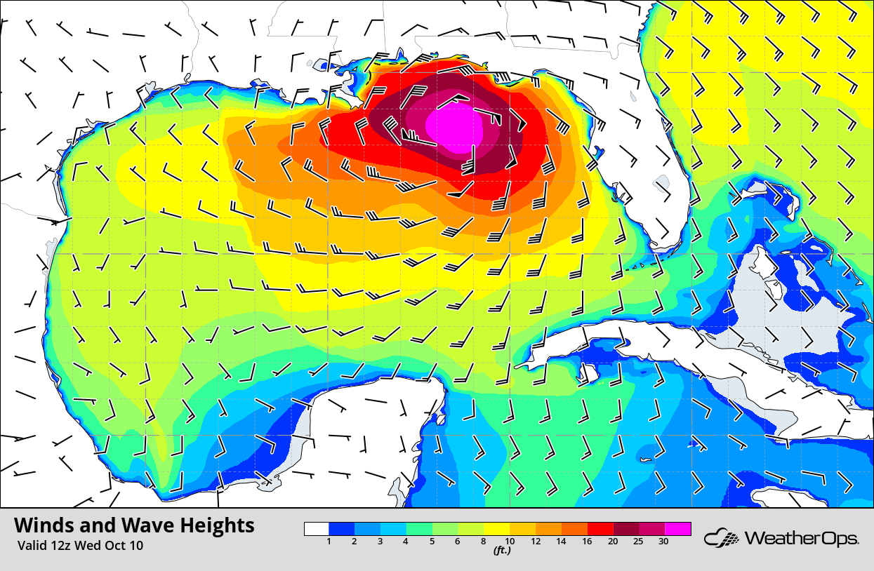
Winds and Wave Heights 7am CDT Wednesday
Snow through Thursday from the Central Plains into the Upper Midwest
An intensifying area of low pressure will lift northeastward from the Plains into the Great Lakes. Accumulating snow is expected across the Plains today and the Upper Midwest Wednesday into Thursday. Snow accumulations will range 3-6 inches with locally higher amounts in excess of 8 inches.
Major Cities in Region: North Platte, NE, Pierre, SD, Grand Forks, ND, International Falls, MN
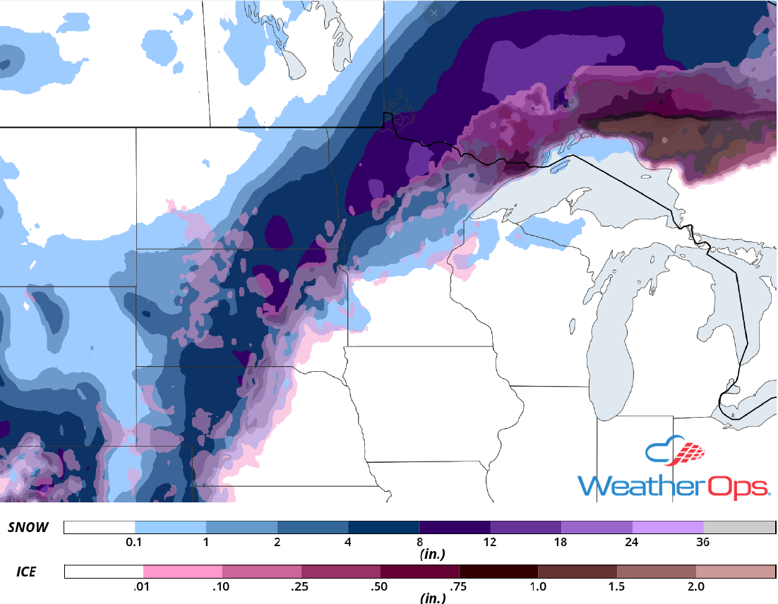
Snow Accumulation through Thursday
Potential for Thunderstorms across the Midwest on Wednesday
A slow moving area of low pressure and cold front will allow for the development of isolated to scattered thunderstorms across portions of the Midwest on Wednesday. While conditions are not expected to be overly favorable for the development of severe thunderstorms, a few strong storms capable of producing gusty winds may develop.
Major Cities in Region: Springfield, IL, Madison, WI, Green Bay, WI, Milwaukee, WI, Chicago, IL, Traverse City, MI, Lansing, MI
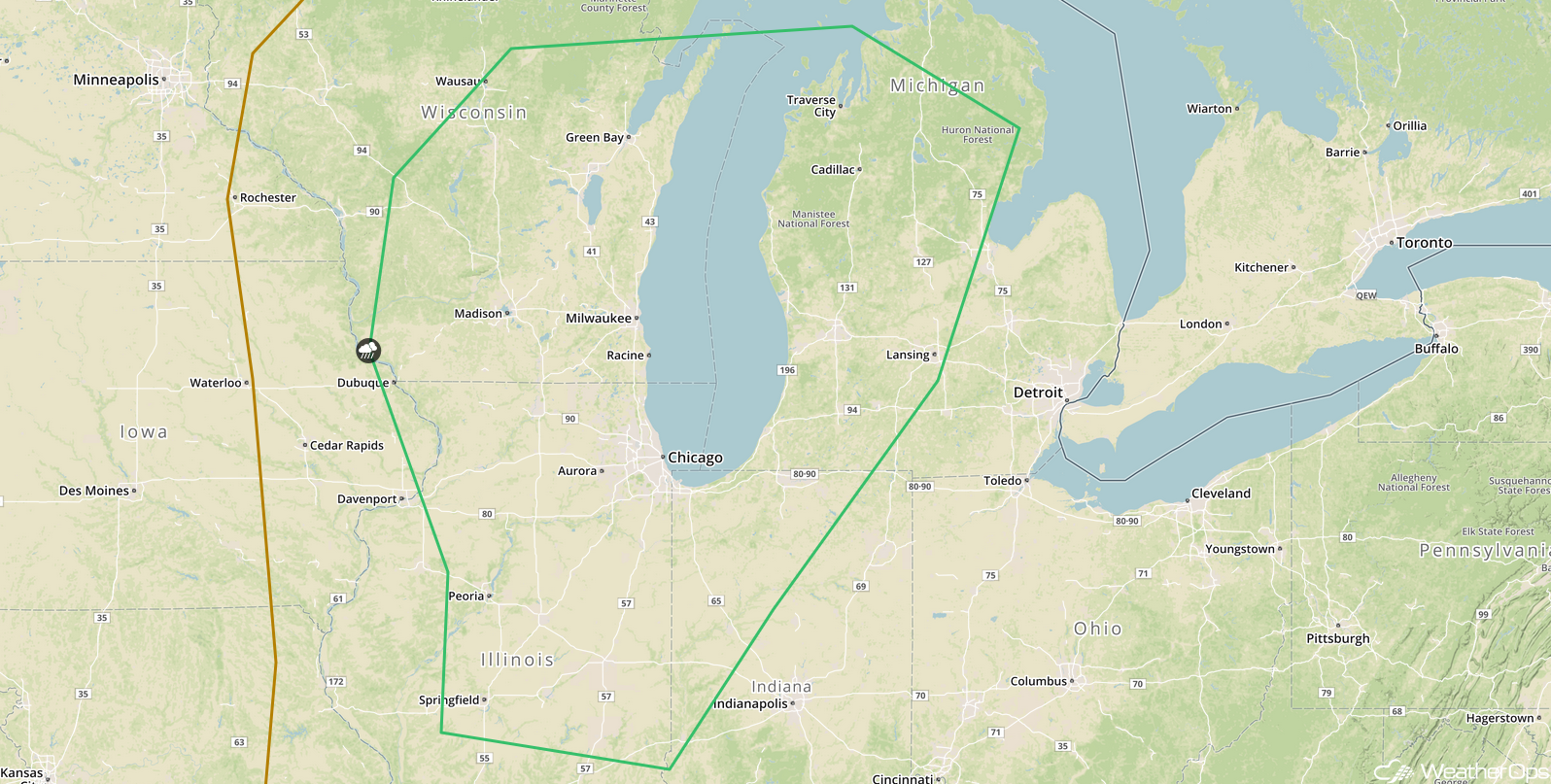
SPC Convective Outlook for Wednesday
Risk for Excessive Rainfall Wednesday across the Great Lakes
In addition to the thunderstorm risk above, there will be a potential for excessive rainfall. Rainfall amounts of 1-3 inches with locally higher amounts in excess of 4 inches are expected.
Major Cities in Region: Wausau, WI, Marquette, MI
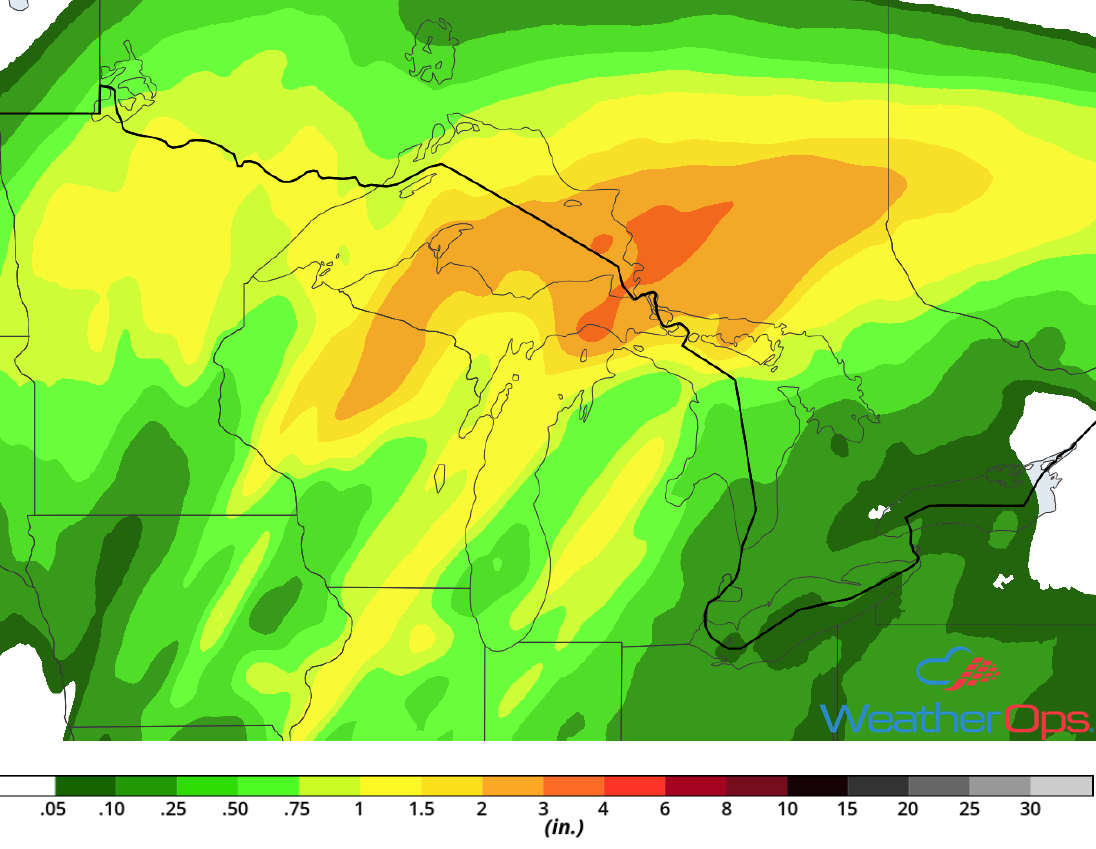
Rainfall Accumulation for Wednesday
Excessive Rainfall for the Southeast Wednesday and Thursday
As Hurricane Michael approaches and moves through the Southeast on Wednesday and Thursday, deep tropical moisture will spread northward. This will bring an increased risk for excessive rainfall across the region. Rainfall amounts will range 5-10 inches with locally higher amounts in excess of 12 inches, resulting in a risk for flooding and flash flooding.
Major Cities in Region: Tallahassee, FL, Albany, GA, Macon, GA, Columbia, SC
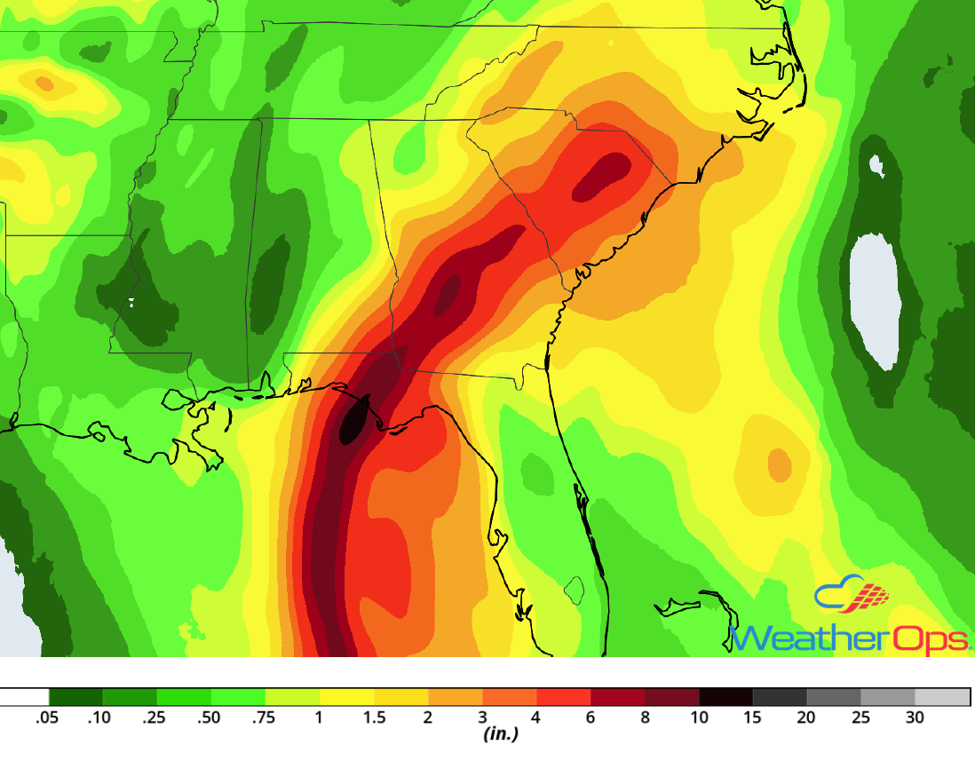
Rainfall Accumulation for Wednesday and Thursday
Tropical Update
Hurricane Michael (green oval) is 335 miles south-southwest of Apalachicola, Florida and is moving northward at 12 mph. This motion is expected to continue through tonight, followed by a northeastward track Wednesday and Thursday. On the forecast track, the center of Michael will move across the eastern Gulf of Mexico through tonight. The center of Michael is expected to move inland over the Florida Panhandle or Big Bend area on Wednesday, and then move northeastward across the Southeast Wednesday night and Thursday. It will move off the Mid Atlantic coast by Friday. Maximum sustained winds are at 110 mph with higher gusts. Additional strengthening is expected and Michael is forecast to make landfall as a category 2 hurricane.
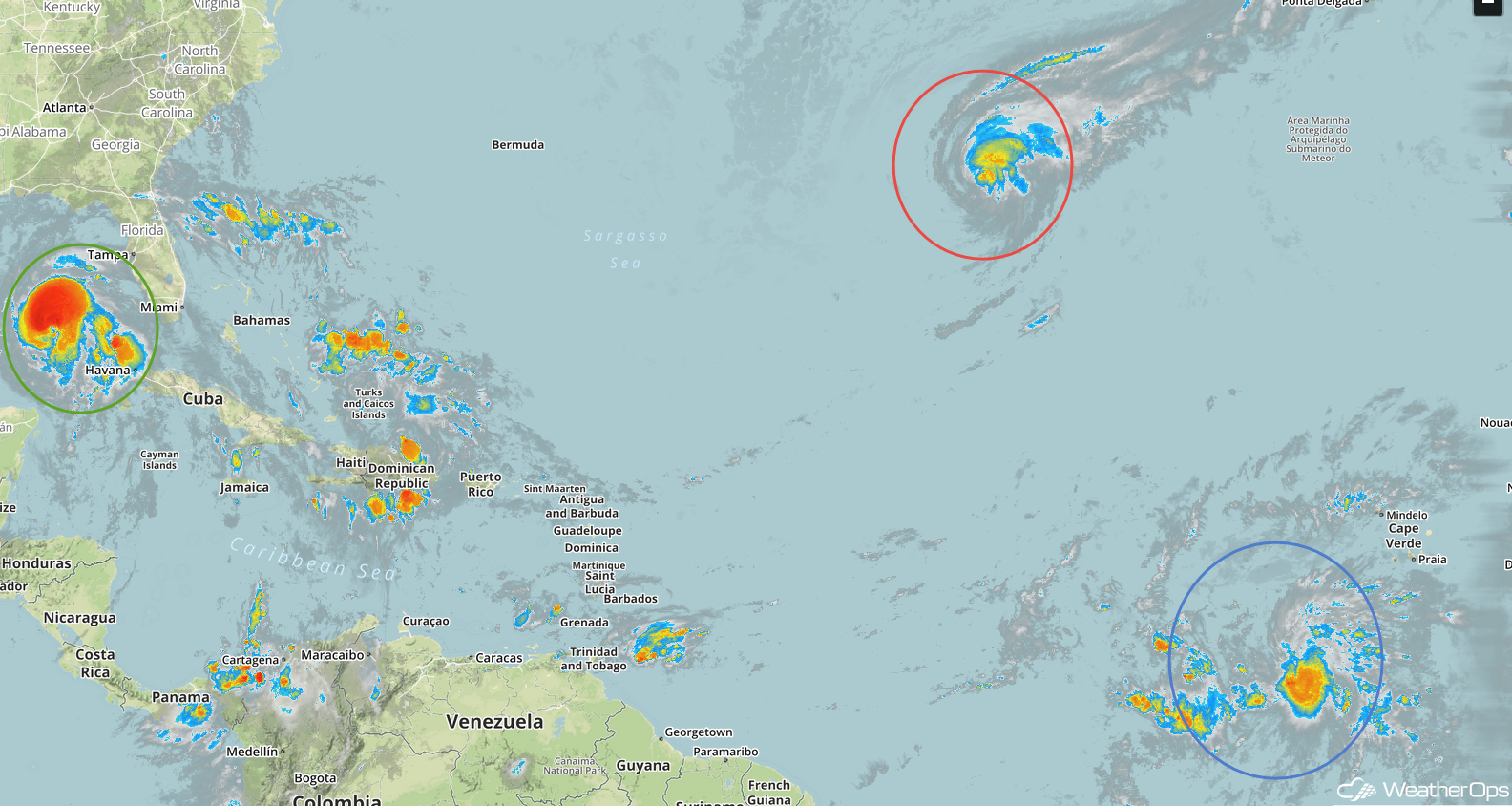
Tropical Storm Leslie (red oval) is 1045 miles west-southwest of the Azores and is moving south-southeastward at 13 mph. This general motion is expected to continue for the next day or so. A slower motion and a turn toward the east-northeast or northeast is expected by Wednesday. Maximum sustained winds are at 65 mph with higher gusts. Some strengthening is expected and Leslie is forecast to become a hurricane again on Wednesday.
Tropical Storm Nadine (blue oval) is 480 miles southwest of the southernmost Cabo Verde Islands and is moving west-northwestward at 9 mph. This motion is expected to continue through tonight with a turn toward the northwest expected on Wednesday. Maximum sustained winds are near 40 mph with higher gusts. Additional strengthening is forecast through Wednesday, with weakening expected to begin by early Thursday. Nadine is expected to weaken to a depression on Friday.
Enhanced Infrared Satellite
A Look Ahead
Hurricane Michael will continue moving across the Carolinas on Friday. Rainfall amounts of 2-4 inches with locally higher amounts in excess of 6 inches are expected, leading to a risk for flooding. Going into the weekend, heavy rain is expected across the Southern Plains on Saturday as an area of low pressure develops. This activity will extend from the Mid Mississippi Valley into west Texas on Sunday. In addition, snow may develop across portions of Colorado and northwest Kansas on Sunday as an upper level system moves across the region. As the area of low pressure over the Plains moves into the Great Lakes on Monday, showers and thunderstorms are forecast from the Great Lakes into the Mid Mississippi Valley.
